Treaty of St. Mary's

Last updated
A marker on the border of the purchase near Delphi, Indiana. New Purchase Boundary marker (Delphi, Indiana).png
A marker on the border of the purchase near Delphi, Indiana.

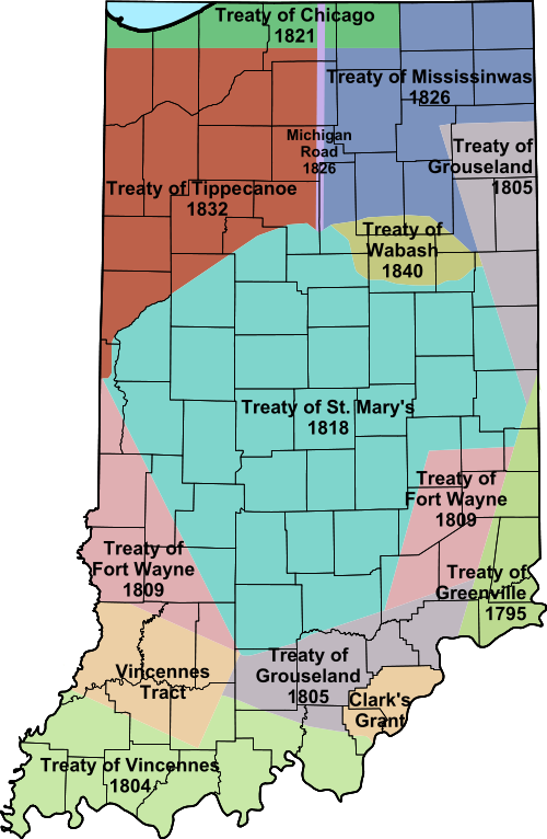
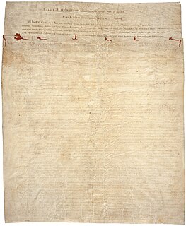
The Treaty of St. Mary's (also known as the Treaty with the Miami, 1818) was signed on October 6, 1818, at Saint Mary's, Ohio, between representatives of the United States and the Miami tribe and others living in their territory. The accord contained seven articles. Based on the terms of the accord, the Miami ceded territories south of the Wabash River covering a large portion of central Indiana, subsequently known as the New Purchase, to the United States. In another tenet of the accord, the United States agreed to pay the Miami a perpetual annuity of fifteen thousand dollars. Moreover, the United States agreed to construct one gristmill and one sawmill, as well as provide one blacksmith, one gunsmith, and agricultural implements. The Miami would also be provided one hundred and sixty bushels of salt annually. [1]

United States federal republic in North America

The United States of America (USA), commonly known as the United States or America, is a country composed of 50 states, a federal district, five major self-governing territories, and various possessions. At 3.8 million square miles, the United States is the world's third or fourth largest country by total area and is slightly smaller than the entire continent of Europe's 3.9 million square miles. With a population of over 327 million people, the U.S. is the third most populous country. The capital is Washington, D.C., and the largest city by population is New York City. Forty-eight states and the capital's federal district are contiguous in North America between Canada and Mexico. The State of Alaska is in the northwest corner of North America, bordered by Canada to the east and across the Bering Strait from Russia to the west. The State of Hawaii is an archipelago in the mid-Pacific Ocean. The U.S. territories are scattered about the Pacific Ocean and the Caribbean Sea, stretching across nine official time zones. The extremely diverse geography, climate, and wildlife of the United States make it one of the world's 17 megadiverse countries.

Wabash River tributary of the Ohio River in the United States of America

The Wabash River is a 503-mile-long (810 km) river in Ohio and Indiana, United States, that flows from the headwaters near the middle of Ohio's western border northwest then southwest across northern Indiana turning south along the Illinois border where the southern portion forms the Indiana-Illinois border before flowing into the Ohio River. It is the largest northern tributary of the Ohio River. From the dam near Huntington, Indiana, to its terminus at the Ohio River, the Wabash flows freely for 411 miles (661 km). Its watershed drains most of Indiana. The Tippecanoe River, White River, Embarras River and Little Wabash River are major tributaries. The river's name comes from an Illini Indian word meaning "water over white stones".

Gristmill mill; grinds grain into flour

A gristmill grinds cereal grain into flour and middlings. The term can refer to both the grinding mechanism and the building that holds it.

Contents

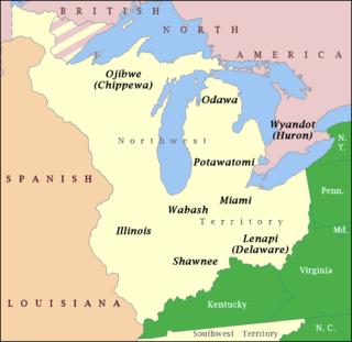
The treaty resulted in the removal of the Delaware Indians who dominated central and east central Indiana to west of the Mississippi river by 1820, clearing the way for colonization by settlers migrating west from Cincinnati and Ohio River settlements.

Text

Map showing extent of the treaty lands. Indiana Indian treaties.svg
Map showing extent of the treaty lands.

Introduction

Articles of a treaty made and concluded, at St. Mary's, in the State of Ohio, between Jonathan Jennings, Lewis Cass, and Benjamin Parke, Commissioners of the United States, and the Miami nation of Indians.

Article 1

The Miami nation of Indians cede to the United States the following tract of country: Beginning at the Wabash river, where the present Indian boundary line crosses the same, near the mouth of Raccoon creek; thence, up the Wabash river, to the reserve at its head, near Fort Wayne; thence, to the reserve at Fort Wayne; thence, with the lines thereof, to the St. Mary's river; thence, up the St. Mary's river, to the reservation at the portage; thence, with the line of the cession made by the Wyandot nation of Indians to the United States, at the foot of the Rapids of the Miami of Lake Erie, on the 29th day of September, in the year of our Lord one thousand eight hundred and seventeen, to the reservation at Loramie's store; thence, with the present Indian boundary line, to Fort Recovery; and, with the line, following the courses thereof, to the place of beginning.

Article 2

From the cession aforesaid the following reservations, for the use of the Miami nation of Indians, shall be made; one reservation, extending along the Wabash river, from the mouth of Salamanie river to the mouth of Eel river, and from those points, running due south, a distance equal to a direct line from the mouth of Salamanie river to the mouth of Eel river. One other reservation, of two miles (3 km) square, on the river Salamanie, at the mouth of Atchepongqwawe creek. One other reservation, of six miles (10 km) square, on the Wabash river, below the forks thereof. One other reservation, of ten miles (16 km) square, opposite the mouth of the river A Bouette. One other reservation, of ten miles (16 km) square, at the village on Sugar Tree Creek. One other reservation, of two miles (3 km) square, at the mouth of a creek, called Flat Rock, where the road to White river crosses the same.

Article 3

Land grants in Ohio enumerated in Article 3 of this treaty Indian Land Grants 218.png
Land grants in Ohio enumerated in Article 3 of this treaty

The United States agree to grant, by patent, in fee simple, to Jean Bapt. Richardville, principal chief of the Miami nation of Indians, the following tracts of land: Three sections of land, beginning about twenty-five rods [125 m] below his house, on the river St. Mary's, near Fort Wayne; thence, at right angles with the course of the river, one mile (1.6 km); and from this line, and the said river, up the stream thereof, for quantity. Two sections, upon the east side of the St. Mary's river, near Fort Wayne, running east one mile (1.6 km) with the line of the military reservation; thence, from that line, and from the river, for quantity. Two sections, on the Twenty-seven mile creek, where the road from St. Mary's to Fort Wayne crosses it, being one section on each side of said creek. Two sections on the left bank of the Wabash, commencing at the forks and running down the river.

The United States also agree to grant to each of the following persons, being Miami Indians by birth, and their heirs, the tracts of land herein described. To Joseph Richardville and Joseph Richardville, jun. two sections of land, being one on each side of the St. Mary's river, and below the reservation made on that river by the treaty of Greenville, in 1795. To Wemetche or the Crescent, one section, below and adjoining the reservation of Anthony Chesne, on the west side of the St. Mary's river, and one section immediately opposite to Macultamunqua or Black Loon.

To Keenquatakqua or Long Hair, Aronzon or Twilight, Peconbequa or a Woman striking, Aughquamauda or Difficulty, and to Miaghqua or Noon, as joint tenants, five sections of land upon the Wabash river, the centre of which shall be the Wyandot village, below the mouth of Tippecanoe river. To François Godfroy, six sections of land, on the Salamanie river, at a place called La Petite Prairie. To Louis Godfroy, six sections of land, upon the St. Mary's river, above the reservation of Anthony Shane. To Charley, a Miamie chief, one section of land, on the west side of the St. Mary's river, below the section granted to Pemetche or the Crescent. To the two eldest children of Peter Langlois, two sections of land, at a place formerly called Village du Puant, at the mouth of the river called Pauceaupichoux.

To the children of Antoine Bondie, two sections of land, on the border of the Wabash river, opposite a place called l'Else a l'Aille. To François Lafontaine and his son, two sections of land, adjoining and above the two sections granted to Jean Bapt. Richardville, near Fort Wayne, and on the same side of the St. Mary's river. To the children of Antoine Rivarre, two sections of land, at the mouth of the Twenty-seven mile creek, and below the same. To Peter Langlois' youngest child, one section of land, opposite the Chipaille, at the Shawnese village. To Peter Labadie, one section of land, on the river St. Mary's, below the section granted to Charley. To the son of George Hunt, one section of land, on the west side of the St. Mary's river, adjoining the two sections granted to François Lafontaine and his son.

To Meshenoqua or the Little Turtle, one section of land, on the south side of the Wabash, where the portage path strikes the same. To Josette Beaubien, one section of land on the left bank of the St. Mary's, above and adjoining the three sections granted to Jean Bapt. Richardville. To Ann Turner, a half-blooded Miami, one section of land on the northwest side of the Wabash river, to commence at the mouth of Fork creek, on the west bank of the said creek, and running up said creek one mile (1.6 km) in a direct line, thence at right angles with this line for quantity. To Rebecca Hackley, a half-blooded Miami, one section of land, to be located at the Munsey town, on White river, so that it shall extend on both sides to include three hundred and 20 acres (81,000 m2) of the prairie, in the bend of the river, where the bend assumes the shape of a horse shoe.

Little Turtle Chief of the Miami people (c. 1747 – July 14, 1812)

Little Turtle,, was a Sagamore (chief) of the Miami people, who became one of the most famous Native American military leaders. Historian Wiley Sword calls him "perhaps the most capable Indian leader then in the Old Northwest," although he later signed several treaties ceding land, which caused him to lose his leader status during the battles which became a prelude to the War of 1812. In the 1790s, Mihšihkinaahkwa led a confederation of native warriors to several major victories against U.S. forces in the Northwest Indian Wars,sometimes called "Little Turtle's War", particularly St. Claires Defeat in 1791, wherein the confederation defeated General Arthur St. Clair, who lost 900 men in the most decisive loss by the U.S. Army against Native American forces.

To William Wayne Wells, a half-blooded Miami, one section of land, at the mouth of the Fork creek, where the reservation for Ann Turner commences, running down the Wabash river on the northwest bank one mile (1.6 km); thence, back one mile (1.6 km); thence, east one mile (1.6 km), to the boundary line of the grant to Ann Turner. To Mary Wells, a half-blooded Miami, one section of land, at the mouth of Stoney creek, on the southeast side of the Wabash river, the centre of which shall be at the mouth of said creek, running with the meanders thereof, up and down the Wabash river, one half mile, and thence back for quantity. To Jane Turner Wells, a half-blooded Miami, one section of land, on the northwest side of the Wabash river, to commence on the west bank of said river, opposite the old lime kiln; thence, down the said river one mile (1.6 km) and back for quantity.

Article 4

The Miami nation of Indians assent to the cession made by the Kickapoos to the United States, by the treaty concluded at Vincennes, on the ninth day of December, one thousand eight hundred and nine.

Article 5

In consideration of the cession and recognition aforesaid, the United States agree to pay to the Miami nation of Indians, a perpetual annuity of fifteen thousand dollars, which, together with all annuities which, by any former treaty, the United States have engaged to pay to the said Miami nation of Indians, shall be paid in silver. The United States will cause to be built for the Miamis one gristmill and one saw-mill, at such proper sites as the chiefs of the nation may select, and will provide and support one blacksmith and one gunsmith for them, and provide them with such implements of agriculture as the proper agent may think necessary. The United States will also cause to be delivered, annually, to the Miami nation, one hundred and sixty bushels of salt.

Article 6

The several tracts of land which, by the third article of this treaty, the United States have engaged to grant to the persons therein mentioned, except the tracts to be granted to Jean Bapt. Richardville, shall never be transferred by the said persons or their heirs, without the approbation of the President of the United States.

Article 7

This treaty shall be obligatory on the contracting parties after the same shall be ratified by the President of the United States, by and with the advice and consent of the Senate thereof. In testimony whereof, the said Jonathan Jennings, Lewis Cass, and Benjamin Parke, commissioners as aforesaid, and the chiefs and warriors of the Miami nation of Indians, have hereunto set their hands, at St. Mary's, the sixth day of October, in the year of our Lord one thousand eight hundred and eighteen.

Signatories

Jonathan Jennings American politician

Jonathan Jennings was the first governor of Indiana and a nine-term congressman from Indiana. Born in either Hunterdon County, New Jersey, or Rockbridge County, Virginia, he studied law before immigrating to the Indiana Territory in 1806. Jennings initially intended to practice law, but took jobs as an assistant at the federal land office at Vincennes and assistant to the clerk of the territorial legislature to support himself, and pursued interests in land speculation and politics. Jennings became involved in a dispute with the territorial governor, William Henry Harrison, that soon led him to enter politics and set the tone for his early political career. In 1808 Jennings moved to the eastern part of the Indiana Territory and settled near Charlestown, in Clark County. He was elected as the Indiana Territory's delegate to the U.S. Congress by dividing the pro-Harrison supporters and running as an anti-Harrison candidate. By 1812 he was the leader of the anti-slavery and pro-statehood faction of the territorial government. Jennings and his political allies took control of the territorial assembly and dominated governmental affairs after the resignation of Governor Harrison in 1812. As a congressional delegate Jennings aided passage of the Enabling Act in 1816, which authorized the organization of Indiana's state government and state constitution. He was elected president of the Indiana constitutional convention, held in Corydon in June 1816, where he helped draft the state's first constitution. Jennings supported the effort to ban slavery in the state and favored a strong legislative branch of government.

Lewis Cass American politician

Lewis Cass was an American military officer, politician, and statesman. He represented Michigan in the United States Senate and served in the Cabinets of two U.S. Presidents, Andrew Jackson and James Buchanan. He was also the 1848 Democratic presidential nominee and a leading spokesman for the Doctrine of Popular Sovereignty, which held that the people in each territory should decide whether to permit slavery.

Jean Baptiste Richardville Chief of the Miami people

Jean Baptiste de Richardville, known as Pinšiwa in Miami and John Richardville, was the last akima of the Miami people. He was a signatory to the Treaty of Greenville (1795) and later treaties with the United States through the Treaty of Mississinewas (1826). A fur trader who controlled an important portage connecting the Maumee River to the Little River, by his death in 1841 he was considered the wealthiest man in Indiana. He had acquired more than 20 square miles of property along the rivers.

In presence of—

See also

Indian removals in Indiana

Indian removals in Indiana followed a series of the land cession treaties made between 1795 and 1846 that led to the removal of most of the native tribes from Indiana. Some of the removals occurred prior to 1830, but most took place between 1830 and 1846. The Lenape (Delaware), Piankashaw, Kickapoo, Wea, and Shawnee were removed in the 1820s and 1830s, but the Potawatomi and Miami removals in the 1830s and 1840s were more gradual and incomplete, and not all of Indiana’s Native Americans voluntarily left the state. The most well-known resistance effort in Indiana was the forced removal of Chief Menominee and his Yellow River band of Potawatomi in what became known as the Potawatomi Trail of Death in 1838, in which 859 Potawatomi were removed to Kansas and at least forty died on the journey west. The Miami were the last to be removed from Indiana, but tribal leaders delayed the process until 1846. Many of the Miami were permitted to remain on land allotments guaranteed to them under the Treaty of St. Mary's (1818) and subsequent treaties.

Related Research Articles

Indian Territory U.S. 17th-, 18th- and early-20th-century territory set aside by the United States Government for the relocation of the indigenous peoples of the Americas

As general terms, Indian Territory, the Indian Territories, or Indian country describe an evolving land area set aside by the United States Government for the relocation of Native Americans who held aboriginal title to their land. In general, the tribes ceded land they occupied in exchange for land grants in 1803. The concept of an Indian Territory was an outcome of the 18th- and 19th-century policy of Indian removal. After the Civil War (1861–1865), the policy of the government was one of assimilation.

Miami people Native American nation originally found in what is now Indiana, Michigan, and Ohio

The Miami are a Native American nation originally speaking one of the Algonquian languages. Among the peoples known as the Great Lakes tribes, it occupied territory that is now identified as Indiana, southwest Michigan, and western Ohio. By 1846, most of the Miami had been removed to Indian Territory. The Miami Tribe of Oklahoma is the only federally recognized tribe of Miami Indians in the United States. The Miami Nation of Indiana is an unrecognized tribe.

Northwest Territory United States territory (1787-1803)

The Northwest Territory in the United States was formed after the American Revolutionary War, and was known formally as the Territory Northwest of the River Ohio. It was the initial post-colonial Territory of the United States and encompassed most of pre-war British colonial territory west of the Appalachian mountains north of the Ohio River. It included all the land west of Pennsylvania, northwest of the Ohio River and east of the Mississippi River below the Great Lakes. It spanned all or large parts of six eventual U.S. States. It was created as a Territory by the Northwest Ordinance July 13, 1787, reduced to Ohio, eastern Michigan and a sliver of southeastern Indiana with the formation of Indiana Territory July 4, 1800, and ceased to exist March 1, 1803, when the southeastern portion of the territory was admitted to the Union as the state of Ohio, and the remainder attached to Indiana Territory.

Treaty of Greenville 1795 treaty ending the Northwest Indian War

The Treaty of Greenville, formally titled Treaty with the Wyandots, etc., was a 1795 treaty between the United States and Indians of the Northwest Territory including the Wyandot and Delaware, which redefined the boundary between Indian lands and Whiteman's lands in the Northwest Territory.

Tecumsehs War

Tecumseh's War or Tecumseh's Rebellion was a conflict between the United States and an American Indian confederacy led by the Shawnee leader Tecumseh in the Indiana Territory. Although the war is often considered to have climaxed with William Henry Harrison's victory at the Battle of Tippecanoe in 1811, Tecumseh's War essentially continued into the War of 1812, and is frequently considered a part of that larger struggle. The war lasted for two more years, until the fall of 1813, when Tecumseh, as well as his second-in-command, Roundhead, died fighting Harrison's Army of the Northwest at the Battle of the Thames in Upper Canada, near present-day Chatham, Ontario, and his confederacy disintegrated. Tecumseh's War is viewed by some academic historians as being the final conflict of a longer term military struggle for control of the Great Lakes region of North America, encompassing a number of wars over several generations, referred to as the Sixty Years' War.

Wea Native American tribe originally located in western Indiana

The Wea were a Miami-Illinois-speaking Native American tribe originally located in western Indiana, closely related to the Miami Tribe. The name Wea is used today as the a shortened version of their numerous recorded names. The Wea name for themselves (autonym) in their own language is waayaahtanwa, derived from waayaahtanonki, 'place of the whirlpool', where they were first recorded being seen and where they were living at that time. The different spellings of their name are numerous, as they were made by different settlers from different language and educational backgrounds. One French version is Ouiatenon; another Ouiateno; there were Wea villages, whose sites are now known as Lafayette and Terre Haute, Indiana, respectively. In 2004 the Indiana Historical Bureau installed a marker commemorating the Wea Village in Terre Haute and its living descendants. The Wea spoke a dialect of Miami, the same language as the Miami Tribe, both from the Algonquian languages.

The Treaty of Mississinewas or the Treaty of Mississinewa also called Treaty of the Wabash is an 1826 treaty between the United States and the Miami and Potawatomi Tribes regarding purchase of Indian lands in Indiana and Michigan. The signing was held at the mouth of the Mississinewa River on the Wabash, hence the name.

Treaty of Detroit treaty between the US and several Native American tribes of Lower Michigan in 1807

The Treaty of Detroit was a treaty between the United States and the Ottawa, Chippewa, Wyandot and Potawatomi Native American nations. The treaty was signed at Detroit, Michigan on November 17, 1807, with William Hull, governor of the Michigan Territory and superintendent of Indian affairs, the sole representative of the U.S.

The Treaty of Fort McIntosh was a treaty between the United States government and representatives of the Wyandotte, Delaware, Chippewa and Ottawa nations of Native Americans. The treaty was signed at Fort McIntosh on January 21, 1785. It contained 10 articles and an addendum.

Treaty of Fort Meigs

The Treaty of Fort Meigs, also called the Treaty of the Maumee Rapids, formally titled, "Treaty with the Wyandots, etc., 1817", was the most significant Indian treaty in Ohio since the Treaty of Greenville in 1795, and resulted in cession by the Indians of nearly all remaining Indian lands in northwestern Ohio. It was the last but one and largest wholesale purchase of Indian land in Ohio.

Treaty of Fort Wayne (1809)

The Treaty of Fort Wayne, sometimes called the Ten O'clock Line Treaty or the Twelve Mile Line Treaty, is an 1809 treaty that obtained 3,000,000 acres of American Indian land for the white settlers of Illinois and Indiana. The tribes involved were the Delaware and others. The negotiations excluded the Shawnee who were minor inhabitants of the area and had been asked to leave the area previously by Miami War Chief Little Turtle. Territorial Governor William Henry Harrison negotiated the treaty with the tribes. The treaty led to a war with the United States begun by Shawnee leader Tecumseh and other dissenting tribesmen in what came to be called "Tecumseh's War".

Treaty of Fort Industry

The Treaty of Fort Industry was a successor treaty to the Treaty of Greenville, which moved the eastern boundary of Indian lands in northern Ohio from the Tuscarawas River and Cuyahoga River westward to a line 120 miles west of the Pennsylvania boundary, which coincided with the western boundary of the Firelands of the Connecticut Western Reserve. In return, the United States agreed "every year forever hereafter, at Detroit, or some other convenient place" to pay $825 for the ceded lands south of the 41st degree of north latitude, and an additional $175 for the Firelands, which lie north of 41 degrees north, which the President would secure from the Connecticut Land Company, for a total of annuity $1000.00, to be "divided between said nations, from time to time, in such proportions as said nations, with the approbation of the President, shall agree."

Western Confederacy Confederation of Native American tribes in the Great Lakes Region

The Western Confederacy, or Western Indian Confederacy, was a loose confederacy of Native Americans in the Great Lakes region of the United States following the American Revolutionary War. The confederacy was also sometimes known as the Miami Confederacy, as many federal officials at the time overestimated the influence and numerical strength of the Miami tribe within the confederation. The confederacy, which had its roots in pan-tribal movements dating to the 1740s, came together in an attempt to resist the expansion of the United States, and the encroachment of American settlers, into the Northwest Territory after Great Britain ceded the region to the United States in the 1783 Treaty of Paris. The resistance resulted in the Northwest Indian War (1785–1795), which ended with an American military victory at the Battle of Fallen Timbers.

Red Hills State Park

Red Hills State Park is an Illinois state park on 967 acres (391 ha) in Lawrence County, Illinois, United States. The park sits at an elevation of 515 feet (157 m). Red Hills State Park is open for year-round recreation including boating, fishing, hunting, hiking and various winter sports. The park includes a restaurant which is open year-round and has banquet facilities.

Potawatomi Trail of Death

The Potawatomi Trail of Death was the forced removal by militia in 1838 of some 859 members of the Potawatomi nation from Indiana to reservation lands in what is now eastern Kansas. They were escorted by armed volunteer militia, the march began at Twin Lakes, Indiana on September 4, 1838, and ended on November 4, 1838, along the western bank of the Osage River, near present-day Osawatomie, Kansas. During the journey of approximately 660 miles (1,060 km) over 61 days, more than 40 persons died, most of them children. It marked the single largest Indian removal in Indiana history.

Treaty of Tippecanoe

The Treaty of Tippecanoe was an agreement between the United States government and Native American Potawatomi tribes in Indiana on October 26, 1832.

Treaty of Fort Wayne (1803)

The Treaty of Fort Wayne was a treaty between the United States and several groups of Native Americans. The treaty was signed on June 7, 1803 and proclaimed December 26, 1803. It more precisely defined the boundaries of the Vincennes tract ceded to the United States by the Treaty of Greenville, 1795.

Indian Removals In Ohio were a process in the late 18th century extending into the 19th century, of the United States usurping Indian land in Ohio Country by conquest, or purchasing such land by treaty, and excluding Indians from it so as to facilitate settlement by European colonists.

References

  1. [Article 5]Indian Affairs: Laws and Treaties - Treaty with the Miami, 1818