Related Research Articles

Stormwater, also written storm water, is water that originates from precipitation (storm), including heavy rain and meltwater from hail and snow. Stormwater can soak into the soil (infiltrate) and become groundwater, be stored on depressed land surface in ponds and puddles, evaporate back into the atmosphere, or contribute to surface runoff. Most runoff is conveyed directly as surface water to nearby streams, rivers or other large water bodies without treatment.
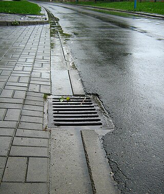
A storm drain, storm sewer, surface water drain/sewer, or stormwater drain is infrastructure designed to drain excess rain and ground water from impervious surfaces such as paved streets, car parks, parking lots, footpaths, sidewalks, and roofs. Storm drains vary in design from small residential dry wells to large municipal systems.

Permeable paving surfaces are made of either a porous material that enables stormwater to flow through it or nonporous blocks spaced so that water can flow between the gaps. Permeable paving can also include a variety of surfacing techniques for roads, parking lots, and pedestrian walkways. Permeable pavement surfaces may be composed of; pervious concrete, porous asphalt, paving stones, or interlocking pavers. Unlike traditional impervious paving materials such as concrete and asphalt, permeable paving systems allow stormwater to percolate and infiltrate through the pavement and into the aggregate layers and/or soil below. In addition to reducing surface runoff, permeable paving systems can trap suspended solids, thereby filtering pollutants from stormwater.
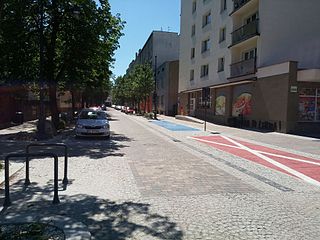
A living street is a street designed with the interests of pedestrians and cyclists in mind by providing enriching and experiential spaces. Living streets also act as social spaces, allowing children to play and encouraging social interactions on a human scale, safely and legally. Living streets consider all pedestrians granting equal access to elders and those who are disabled. These roads are still available for use by motor vehicles; however, their design aims to reduce both the speed and dominance of motorized transport. The reduction of motor vehicle dominance creates more opportunities for public transportation. Living Streets achieve these strategies by implementing the shared space approach. Reducing demarcations between vehicle traffic and pedestrians create a cohesive space without segregating different modes of transportation. Vehicle parking may also be restricted to designated bays. These street design principles first became popularized in the Netherlands during the 1970s, and the Dutch word woonerf is often used as a synonym for living street.

Impervious surfaces are mainly artificial structures—such as pavements that are covered by water-resistant materials such as asphalt, concrete, brick, stone—and rooftops. Soils compacted by urban development are also highly impervious.
The United States Environmental Protection Agency (EPA) Storm Water Management Model (SWMM) is a dynamic rainfall–runoff–subsurface runoff simulation model used for single-event to long-term (continuous) simulation of the surface/subsurface hydrology quantity and quality from primarily urban/suburban areas. It can simulate the Rainfall- runoff, runoff, evaporation, infiltration and groundwater connection for roots, streets, grassed areas, rain gardens and ditches and pipes, for example. The hydrology component of SWMM operates on a collection of subcatchment areas divided into impervious and pervious areas with and without depression storage to predict runoff and pollutant loads from precipitation, evaporation and infiltration losses from each of the subcatchment. Besides, low impact development (LID) and best management practice areas on the subcatchment can be modeled to reduce the impervious and pervious runoff. The routing or hydraulics section of SWMM transports this water and possible associated water quality constituents through a system of closed pipes, open channels, storage/treatment devices, ponds, storages, pumps, orifices, weirs, outlets, outfalls and other regulators.

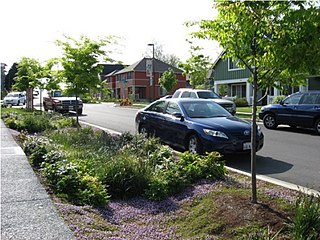
Rain gardens, also called bioretention facilities, are one of a variety of practices designed to increase rain runoff reabsorption by the soil. They can also be used to treat polluted stormwater runoff. Rain gardens are designed landscape sites that reduce the flow rate, total quantity, and pollutant load of runoff from impervious urban areas like roofs, driveways, walkways, parking lots, and compacted lawn areas. Rain gardens rely on plants and natural or engineered soil medium to retain stormwater and increase the lag time of infiltration, while remediating and filtering pollutants carried by urban runoff. Rain gardens provide a method to reuse and optimize any rain that falls, reducing or avoiding the need for additional irrigation. A benefit of planting rain gardens is the consequential decrease in ambient air and water temperature, a mitigation that is especially effective in urban areas containing an abundance of impervious surfaces that absorb heat in a phenomenon known as the heat-island effect.

Surface runoff is the unconfined flow of water over the ground surface, in contrast to channel runoff. It occurs when excess rainwater, stormwater, meltwater, or other sources, can no longer sufficiently rapidly infiltrate in the soil. This can occur when the soil is saturated by water to its full capacity, and the rain arrives more quickly than the soil can absorb it. Surface runoff often occurs because impervious areas do not allow water to soak into the ground. Furthermore, runoff can occur either through natural or human-made processes.

Sustainable drainage systems are a collection of water management practices that aim to align modern drainage systems with natural water processes and are part of a larger green infrastructure strategy. SuDS efforts make urban drainage systems more compatible with components of the natural water cycle such as storm surge overflows, soil percolation, and bio-filtration. These efforts hope to mitigate the effect human development has had or may have on the natural water cycle, particularly surface runoff and water pollution trends.

Daylighting can be defined as "opening up buried watercourses and restoring them to more natural conditions". An alternative definition refers to "the practice of removing streams from buried conditions and exposing them to the Earth's surface in order to directly or indirectly enhance the ecological, economic and/or socio-cultural well-being of a region and its inhabitants". The term is used to refer to the restoration of an originally open-air watercourse, which had at some point been diverted below ground, back into an above-ground channel. Typically, the rationale behind returning the riparian environment of a stream, wash, or river to a more natural state is to reduce runoff, create habitat for species in need of it, or improve an area's aesthetics. In the UK, the practice is also known as deculverting.
Green infrastructure or blue-green infrastructure refers to a network that provides the “ingredients” for solving urban and climatic challenges by building with nature. The main components of this approach include stormwater management, climate adaptation, the reduction of heat stress, increasing biodiversity, food production, better air quality, sustainable energy production, clean water, and healthy soils, as well as more anthropocentric functions, such as increased quality of life through recreation and the provision of shade and shelter in and around towns and cities. Green infrastructure also serves to provide an ecological framework for social, economic, and environmental health of the surroundings. More recently scholars and activists have also called for green infrastructure that promotes social inclusion and equality rather than reinforcing pre-existing structures of unequal access to nature-based services.
Bioretention is the process in which contaminants and sedimentation are removed from stormwater runoff. The main objective of the bioretention cell is to attenuate peak runoff as well as to remove stormwater runoff pollutants.

Urban runoff is surface runoff of rainwater, landscape irrigation, and car washing created by urbanization. Impervious surfaces are constructed during land development. During rain, storms, and other precipitation events, these surfaces, along with rooftops, carry polluted stormwater to storm drains, instead of allowing the water to percolate through soil. This causes lowering of the water table and flooding since the amount of water that remains on the surface is greater. Most municipal storm sewer systems discharge untreated stormwater to streams, rivers, and bays. This excess water can also make its way into people's properties through basement backups and seepage through building wall and floors.

Stormwater harvesting or Stormwater reuse is the collection, accumulation, treatment or purification, and storage of stormwater for its eventual reuse. While rainwater harvesting collects precipitation primarily from rooftops, stormwater harvesting deals with collection of runoff from creeks, gullies, ephemeral streams, underground conveyances. It can also include catchment areas from developed surfaces, such as roads or parking lots, or other urban environments such as parks, gardens and playing fields.
A stormwater fee is a charge imposed on real estate owners for pollution in stormwater drainage from impervious surface runoff.

Water-sensitive urban design (WSUD) is a land planning and engineering design approach which integrates the urban water cycle, including stormwater, groundwater, and wastewater management and water supply, into urban design to minimise environmental degradation and improve aesthetic and recreational appeal. WSUD is a term used in the Middle East and Australia and is similar to low-impact development (LID), a term used in the United States; and Sustainable Drainage System (SuDS), a term used in the United Kingdom.

Low-impact development (LID) is a term used in Canada and the United States to describe a land planning and engineering design approach to manage stormwater runoff as part of green infrastructure. LID emphasizes conservation and use of on-site natural features to protect water quality. This approach implements engineered small-scale hydrologic controls to replicate the pre-development hydrologic regime of watersheds through infiltrating, filtering, storing, evaporating, and detaining runoff close to its source. Green infrastructure investments are one approach that often yields multiple benefits and builds city resilience.
A runoff footprint is the total surface runoff that a site produces over the course of a year. According to the United States Environmental Protection Agency (EPA) stormwater is "rainwater and melted snow that runs off streets, lawns, and other sites". Urbanized areas with high concentrations of impervious surfaces like buildings, roads, and driveways produce large volumes of runoff which can lead to flooding, sewer overflows, and poor water quality. Since soil in urban areas can be compacted and have a low infiltration rate, the surface runoff estimated in a runoff footprint is not just from impervious surfaces, but also pervious areas including yards. The total runoff is a measure of the site’s contribution to stormwater issues in an area, especially in urban areas with sewer overflows. Completing a runoff footprint for a site allows a property owner to understand what areas on his or her site are producing the most runoff and what scenarios of stormwater green solutions like rain barrels and rain gardens are most effective in mitigating this runoff and its costs to the community.

A tree box filter is a best management practice (BMP) or stormwater treatment system widely implemented along sidewalks, street curbs, and car parks. They are used to control the volume and amount of urban runoff pollutants entering into local waters, by providing areas where water can collect and naturally infiltrate or seep into the ground. Such systems usually consist of a tree planted in a soil media, contained in a small, square, concrete box. Tree box filters are popular bioretention and infiltration practices, as they collect, retain, and filter runoff as it passes through vegetation and microorganisms in the soil. The water is then either consumed by the tree or transferred into the storm drain system.
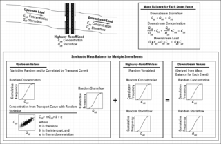
The stochastic empirical loading and dilution model (SELDM) is a stormwater quality model. SELDM is designed to transform complex scientific data into meaningful information about the risk of adverse effects of runoff on receiving waters, the potential need for mitigation measures, and the potential effectiveness of such management measures for reducing these risks. The U.S. Geological Survey developed SELDM in cooperation with the Federal Highway Administration to help develop planning-level estimates of event mean concentrations, flows, and loads in stormwater from a site of interest and from an upstream basin. SELDM uses information about a highway site, the associated receiving-water basin, precipitation events, stormflow, water quality, and the performance of mitigation measures to produce a stochastic population of runoff-quality variables. Although SELDM is, nominally, a highway runoff model is can be used to estimate flows concentrations and loads of runoff-quality constituents from other land use areas as well. SELDM was developed by the U.S. Geological Survey so the model, source code, and all related documentation are provided free of any copyright restrictions according to U.S. copyright laws and the USGS Software User Rights Notice. SELDM is widely used to assess the potential effect of runoff from highways, bridges, and developed areas on receiving-water quality with and without the use of mitigation measures. Stormwater practitioners evaluating highway runoff commonly use data from the Highway Runoff Database (HRDB) with SELDM to assess the risks for adverse effects of runoff on receiving waters.
References
- ↑ "Calculating credits for tree trenches and tree boxes - Minnesota Stormwater Manual". stormwater.pca.state.mn.us. Retrieved 2021-04-06.
- ↑ "Document Display (PURL) | NSCEP | US EPA". nepis.epa.gov. Retrieved 2021-04-06.
- ↑ "Tree Credit Systems and Incentives at the Watershed Scale | Vermont Urban and Community Forestry". vtcommunityforestry.org. Retrieved 2021-03-24.
- 1 2 3 "Tree Credit Systems and Incentives at the Site Scale | Vermont Urban and Community Forestry". vtcommunityforestry.org. Retrieved 2021-03-24.
- ↑ "Sacramento Stormwater Quality Partnership". www.beriverfriendly.net. Retrieved 2021-04-06.
- ↑ "2020 Stormwater Management Manual". Portland.gov. Retrieved 2021-04-06.
- ↑ "Stormwater Retention Credit Trading Program | ddoe". doee.dc.gov. Retrieved 2021-04-06.
- ↑ "Welcome pinelakega.com - BlueHost.com". pinelakega.com. Retrieved 2021-04-06.
- ↑ Marritz, Leda (March 25, 2013). "How Do You Calculate Stormwater Credits for Trees? Part 1: Why tree-based credits are hard to quantify". Deeproot, Green Infrastructure for Your Community. Retrieved 2019-09-24.
- ↑ "Risk and returns of selling trees for carbon credits". FutureBeef. October 30, 2017. Retrieved 2019-09-24.
- ↑ "Resources". Treecoins. 2017-11-01. Retrieved 2019-09-24.
- ↑ Jain, Bhavika (Sep 25, 2016). "Tree plantation: Grow money! 'Tree credits' set to be reality | Mumbai News - Times of India". The Times of India. Retrieved 2019-09-24.