Related Research Articles

In archaeology, excavation is the exposure, processing and recording of archaeological remains. An excavation site or "dig" is the area being studied. These locations range from one to several areas at a time during a project and can be conducted over a few weeks to several years.
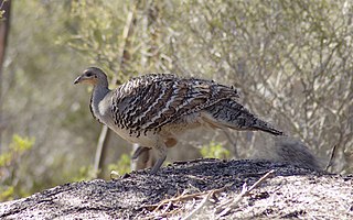
The malleefowl is a stocky ground-dwelling Australian bird about the size of a domestic chicken. It is notable for the large nesting mounds constructed by the males and lack of parental care after the chicks hatch. It is the only living representative of the genus Leipoa, though the extinct giant malleefowl was a close relative.

Arboriculture is the cultivation, management, and study of individual trees, shrubs, vines, and other perennial woody plants. The science of arboriculture studies how these plants grow and respond to cultural practices and to their environment. The practice of arboriculture includes cultural techniques such as selection, planting, training, fertilization, pest and pathogen control, pruning, shaping, and removal.

In archaeological excavation, a feature is a collection of one or more contexts representing some human non-portable activity, such as a hearth or wall. Features serve as an indication that the area in which they are found has been interfered with in the past, usually by humans.

In archaeology a posthole or post-hole is a cut feature used to hold a surface timber or stone. They are usually much deeper than they are wide; however, truncation may not make this apparent. Although the remains of the timber may survive, most postholes are mainly recognisable as circular patches of darker earth when viewed in plan. Archaeologists can use their presence to plot the layout of former structures, as the holes may define its corners and sides. Construction using postholes is known as earthfast or post in ground construction.
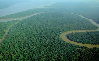
Tropical rainforests are rainforests that occur in areas of tropical rainforest climate in which there is no dry season – all months have an average precipitation of at least 60 mm – and may also be referred to as lowland equatorial evergreen rainforest. True rainforests are typically found between 10 degrees north and south of the equator ; they are a sub-set of the tropical forest biome that occurs roughly within the 28-degree latitudes. Within the World Wildlife Fund's biome classification, tropical rainforests are a type of tropical moist broadleaf forest that also includes the more extensive seasonal tropical forests.

An old-growth forest, sometimes synonymous with primary forest, virgin forest, late seral forest, primeval forest, or first-growth forest—is a forest that has attained great age without significant disturbance, and thereby exhibits unique ecological features, and might be classified as a climax community. The Food and Agriculture Organization of the United Nations defines primary forests as naturally regenerated forests of native tree species where there are no clearly visible indications of human activity and the ecological processes are not significantly disturbed. More than one-third of the world's forests are primary forests. Old-growth features include diverse tree-related structures that provide diverse wildlife habitat that increases the biodiversity of the forested ecosystem. Virgin or first-growth forests are old-growth forests that have never been logged. The concept of diverse tree structure includes multi-layered canopies and canopy gaps, greatly varying tree heights and diameters, and diverse tree species and classes and sizes of woody debris.
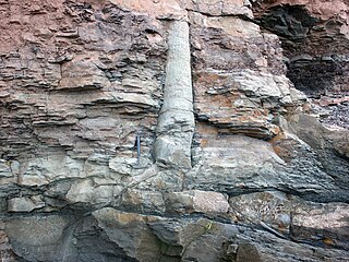
A polystrate fossil is a fossil of a single organism that extends through more than one geological stratum. The word polystrate is not a standard geological term. This term is typically found in creationist publications.

Fulacht fiadh is the name given to one of many burned mounds, dating from the Bronze Age, found in Ireland. Most surviving examples consist of a low horseshoe-shaped mound of charcoal-enriched soil, and heat shattered stone, with a cooking pit located in a slight depression at its centre. In ploughed fields, they are apparent as black spreads of earth interspersed with small sharp stones.
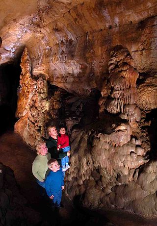
Cave of the Mounds, a natural limestone cave located near Blue Mounds, Wisconsin, United States, is named for two nearby hills called the Blue Mounds. It is located in the southern slope of the east hill. The cave's beauty comes from its many varieties of mineral formations called speleothems. The Chicago Academy of Sciences considers the Cave of the Mounds to be "the significant cave of the upper Midwest" because of its beauty, and it is promoted as the "jewel box" of major American caves. In 1987, the United States Department of the Interior and the National Park Service designated the cave as a National Natural Landmark.
Xerosere is a plant succession that is limited by water availability. It includes the different stages in a xerarch succession. Xerarch succession of ecological communities originated in extremely dry situation such as sand deserts, sand dunes, salt deserts, rock deserts etc. A xerosere may include lithoseres and psammoseres.

A hydrosere is a plant succession which occurs in an area of fresh water such as in oxbow lakes and kettle lakes. In time, an area of open freshwater will naturally dry out, ultimately becoming woodland. During this change, a range of different landtypes such as swamp and marsh will succeed each other.

Soil biology is the study of microbial and faunal activity and ecology in soil. Soil life, soil biota, soil fauna, or edaphon is a collective term that encompasses all organisms that spend a significant portion of their life cycle within a soil profile, or at the soil-litter interface. These organisms include earthworms, nematodes, protozoa, fungi, bacteria, different arthropods, as well as some reptiles, and species of burrowing mammals like gophers, moles and prairie dogs. Soil biology plays a vital role in determining many soil characteristics. The decomposition of organic matter by soil organisms has an immense influence on soil fertility, plant growth, soil structure, and carbon storage. As a relatively new science, much remains unknown about soil biology and its effect on soil ecosystems.
The Crocodile Lake National Wildlife Refuge is part of the United States National Wildlife Refuge System, located in north Key Largo, less than 40 miles (64 km) south of Miami off SR 905. The 6,686 acre (27.1 km2) refuge opened during the year of 1980, under the Land and Water Conservation Fund Act of 1965 and the Endangered Species Act of 1973. It was established in order to protect critical breeding and nesting habitat for the threatened American crocodile and other wildlife. This area also includes 650 acres (2.6 km2) of open water in and around the refuge. In addition to being one of only three breeding populations of the American crocodile, the refuge is home to tropical hardwood hammock, mangrove forest, and salt marsh. It is administered as part of the National Key Deer Refuge which is also located in the Florida Keys.

Prehistory of Ohio provides an overview of the activities that occurred prior to Ohio's recorded history. The ancient hunters, Paleo-Indians, descended from humans that crossed the Bering Strait. There is evidence of Paleo-Indians in Ohio, who were hunter-gatherers that ranged widely over land to hunt large game. For instance, mastodon bones were found at the Burning Tree Mastodon site that showed that it had been butchered. Clovis points have been found that indicate interaction with other groups and hunted large game. The Paleo Crossing site and Nobles Pond site provide evidence that groups interacted with one another. The Paleo-Indian's diet included fish, small game, and nuts and berries that gathered. They lived in simple shelters made of wood and bark or hides. Canoes were created by digging out trees with granite axes.
The Sixtoe Mound site (9MU100) is an archaeological site in Murray County, Georgia excavated by Arthur Randolph Kelly from 1962-1965 as a part of the Carters Dam project conducted for the National Park Service by the University of Georgia. The site consisted of a low platform mound and an associated village. The majority of the mound was excavated, while the village received little excavation.

Hügelkultur, literally mound bed or mound culture is a horticultural technique where a mound constructed from decaying wood debris and other compostable biomass plant materials is later planted as a raised bed. Adopted by permaculture advocates, it is suggested the technique helps to improve soil fertility, water retention, and soil warming, thus benefitting plants grown on or near such mounds.
Pit and mounds are small, persistent microtopographical features that present themselves after a disturbance event occurs and uproots trees via windthrow. The uprooted tree falls, and a pit forms in the forest floor where the root mass and associated soil matrix used to be. Eventually after a period of time in which the roots decay, the associated soil matrix that was pulled out of the ground with the roots falls back to the ground, creating a corresponding mound.
This page is a glossary of archaeology, the study of the human past from material remains.
The Taiga of North America is a Level I ecoregion of North America designated by the Commission for Environmental Cooperation (CEC) in its North American Environmental Atlas.
References
- ↑ Darvill, T (ed.) (2003). Oxford Concise Dictionary of Archaeology, Oxford: Oxford University Press. ISBN 0-19-280005-1.
- 1 2 3 4 Gabet, Emmanual. "When a tree falls in the forest, does it make a soil?". Science Education Resource Center at Carleton College. Archived from the original on 2021-05-03. Retrieved 2023-04-29.
- ↑ Clinton, Barton D.; Baker, Corey R. 2000. Catastrophic windthrow in the southern Appalachians: characteristics of pits and mounds and initial vegetation responses. Forest Ecology and Management 126: 51-60.
| | This article relating to archaeology is a stub. You can help Wikipedia by expanding it. |