
The Pomona Valley is located in the Greater Los Angeles Area between the San Gabriel Valley and San Bernardino Valley in Southern California. The valley is approximately 30 miles (48 km) east of downtown Los Angeles.

The Cucamonga Valley is a region of southwestern San Bernardino County and northwestern Riverside County, in southern California. It is located below the San Gabriel Mountains in the Inland Empire region.

Arrowhead Springs is a highly mountainous neighborhood in the 81-square-mile (210 km2) municipality of San Bernardino, California, officially annexed to the city on November 19, 2009. The neighborhood lies below the Arrowhead geological monument, which is California Historical Landmark #977.

The Victor Valley is a valley in the Mojave Desert and subregion of the Inland Empire, in San Bernardino County in Southern California.

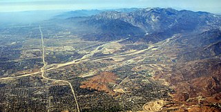
The San Bernardino Valley is a valley in Southern California located at the south base of the Transverse Ranges. It is bordered on the north by the eastern San Gabriel Mountains and the San Bernardino Mountains; on the east by the San Jacinto Mountains; on the south by the Temescal Mountains and Santa Ana Mountains; and on the west by the Pomona Valley. Elevation varies from 590 feet (180 m) on valley floors near Chino to 1,380 feet (420 m) near San Bernardino and Redlands. The valley floor is home to over 80% of the more than 4 million people in the Inland Empire region.
Wildwood Canyon is a canyon and California state park in the eastern foothills of the San Bernardino Mountains, within San Bernardino County, southern California.
Lytle Creek, California, is an approximately 18-mile-long (29 km) stream in southwestern San Bernardino County near the city of San Bernardino. It is a tributary of Warm Creek, a tributary of the Santa Ana River. The Mormon settlers of San Bernardino named the stream "Lytle Creek" after their leader, Captain Andrew Lytle. The Tongva village of Wa’aachnga was located along Lytle Creek.

Norton Air Force Base (1942–1994) was a United States Air Force facility 2 miles (3.2 km) east of downtown San Bernardino in San Bernardino County, California.

Apple Valley Airport is a public airport three miles (4.8 km) north of Apple Valley in San Bernardino County, California, United States. The airport has two runways and is used for general aviation. It opened around 1970.
Panamint Springs is private resort in Inyo County, California. It consists of a motel, cabins, RV and tent campsites, restaurant, and gas station, all operated by Cassell Enterprises, LLC. It lies at an elevation of 1926 feet.
Redlands Municipal Airport is two miles (3.2 km) northeast of downtown Redlands, serving San Bernardino County, California, United States. This general aviation airport covers 194 acres (79 ha) and has one runway.

High Desert is a vernacular region with non-discrete boundaries covering areas of the western Mojave Desert in Southern California. The region encompasses various terrain with elevations generally between 2,000 and 4,000 ft above sea level, and is located just north of the San Gabriel, San Bernardino, and Little San Bernardino Mountains.
San Gorgonio High School is a comprehensive senior high school in the San Bernardino City Unified School District. Its campus is located at the corner of Pacific Street and Arden Avenue on the border between San Bernardino and Highland, California.
The Yuhaaviatam of San Manuel Nation is a federally recognized tribe of Serrano people in San Bernardino County, California.

Crafton is an unincorporated community in San Bernardino County, California, United States, located east of Redlands, south of Mentone and west of Yucaipa, California.

The Hospitality Lane District is a central business district in San Bernardino, California, located 2–3 miles southeast of the city's downtown area along the street of the same name. It is adjacent to Interstate 10, and is only a few miles away from San Bernardino International Airport. The district is home to the headquarters for the San Bernardino Community College District. The district primarily includes retail establishments, dining, and many of the city's hotels; it has been described as a "center of shopping and restaurant activity" in the San Bernardino Valley with some of the Inland Empire's "finest hotels, restaurants and office buildings". In addition, the area has attracted office development. Hospitality Lane is one of the most prosperous and developed areas in San Bernardino, a city which is otherwise economically troubled. However, the district has experienced increased crime as a result of its development, particularly due to its nightclubs. The district was built in a depressed area of San Bernardino after the city's Redevelopment Agency cleared the land and sold it to developers. In 2006, the last vacant property in Hospitality Lane was sold; at the time, the district had 16 restaurants. In 2011, the city proposed a center-lane exclusive high-speed bus line known as sbX in the Hospitality Lane area and is under construction as of 2013 with an expected launch date of January 2014. In 2008, the district experienced a small downturn as several businesses in the area closed; local economists stated that the downturn may have been caused by the economic recession.
Ontario Air National Guard Station is a former California Air National Guard facility located alongside Ontario International Airport in Ontario, California.
Pioneer Memorial Cemetery in San Bernardino, San Bernardino County, California, is an extant burial place for the early settlers in the city. The cemetery was founded in April 1857. Remains of area pioneers previously interred at the unmarked Seccombe Lake Cemetery were relocated to the Pioneer Memorial Cemetery.

Glen Helen Regional Park is a county park located in San Bernardino, California, United States adjacent to the Cajon Pass. It was the site of both US Festivals of the early 1980s. It is also home to the Glen Helen Amphitheater, the largest outdoor amphitheater in the United States. The park also hosts several off-road races since 1985.
Bunker Hill is a bluff in the City of San Bernardino in San Bernardino County, California. Bunker Hill trends northwest–southeast from 34°05′19″N117°18′18″W through the campus of San Bernardino Valley College on the northeast to 34°04′46″N117°18′6″W where it overlooks Lytle Creek on the southeast. Its tallest point is over 1080 feet at the top of a ridge marking its southwest facing edge at 34°05′04″N117°18′33″W the top of a ridge, just south of Grant Avenue, that overlooks the southern parking lot of the college. Bunker Hill gives its name to the neighborhood of the city of San Bernardino in the vicinity of this feature.
