Red Hills State Park is an Illinois state park on 967 acres (391 ha) in Lawrence County, Illinois, United States. The park sits at an elevation of 515 feet (157 m). Red Hills State Park is open for year-round recreation including boating, fishing, hunting, hiking and various winter sports. The park includes a restaurant which is open year-round and has banquet facilities.

Des Plaines Fish and Wildlife Area is an Illinois state park on 5,000 acres (2,023 ha) in Will County, Illinois, United States. It is located on floodplain adjacent to the confluence of the Des Plaines River and the Kankakee River to form the Illinois River.
Jasper-Pulaski Fish and Wildlife Area is a hunting & fishing wildlife area administered by the Indiana Department of Natural Resource's Division of Fish & Wildlife. The Division of Fish & Wildlife is dedicated to providing a quality hunting & fishing area while maintaining 8,142 acres of wetland, upland and woodland game habitat.
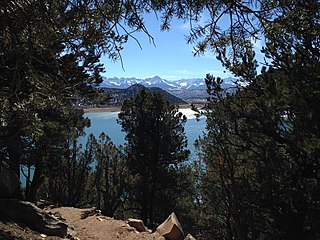
Ridgway State Park is a state park located in Ouray County, Colorado. It is the westernmost state park in Colorado. The park is 21 miles southeast of Montrose, 14 miles northeast of Ouray, it is also 4 miles north of the town of Ridgway and 312 miles southwest of Denver. The current wildlife consists of deer, coyotes, rabbits, and elk. Due to the park's variety of animal life, the park is used as a hunting ground although hunting opportunities are extremely limited due to proximity to developed areas.

Clinch Mountain Wildlife Management Area is a 25,477-acre (103.10 km2) Wildlife Management Area (WMA) in Virginia. It is the second-largest WMA in the Commonwealth, covering portions of Smyth, Washington, Russell, and Tazewell counties.
T. M. Gathright Wildlife Management Area is a 13,428-acre (54.34 km2) Wildlife Management Area (WMA) in Bath County, Virginia. The property's mountainous terrain includes elevations ranging from 1,400 to 3,600 feet above sea level, and is divided by 2,530-acre (10.2 km2) Lake Moomaw. The northwest boundary is marked at the crest of Allegheny Mountain, along the border between Virginia and West Virginia; additional mountains include Bolar Mountain to the west of the lake, and Coles Mountain to its east. A number of streams flow eastward from the summit, terminating at Mill Creek. The primary habitat is upland hardwood forest including mixed stands of oak and hickory, with tulip poplar in some of the more fertile areas. Small non-forested openings are also maintained for the benefit of wildlife.
Hidden Valley Wildlife Management Area is a 6,400-acre (26 km2) Wildlife Management Area in Washington County, Virginia, along its border with Russell County. The area is typified by mountainous mature hardwood forests that have regenerated on land logged in the early twentieth century; a number of small openings which are also maintained as habitat for local wildlife. Its elevation ranges from 2,000 to 4,000 feet above sea level. At the head of the valley is the 60-acre (24 ha) Hidden Valley Lake, which serves as the source of Brumley Creek.
Rapidan Wildlife Management Area is a 10,326-acre (41.79 km2) Wildlife Management Area (WMA) in Madison and Greene counties, Virginia. It is composed of eight separate tracts of land along the eastern slope of the Blue Ridge Mountains; four of these adjoin Shenandoah National Park, and combined they share 25 miles (40 km) of boundary.
Chief Cornstalk Wildlife Management Area is located on 11,772 acres (4,764 ha) in Mason County near Southside, West Virginia. Second growth oak-hickory and mixed hardwoods forests cover much of the rolling and moderately steep slopes. Chief Cornstalk WMA can be reached either on Nine Mile Creek Road off US 35 near Southside, or by Crab Creek Road from State Route 2, south of Gallipolis Ferry.

Green Bottom Wildlife Management Area is located on former plantation lands of U.S. Congressman and Confederate General Albert G. Jenkins. The 1,096 acres (444 ha) in Cabell County and Mason County are located along the banks of the Ohio River about 16 miles (26 km) north of Huntington, West Virginia. The Green Bottom WMA land is a mixture of farmland, mixed hardwood forest, wetlands, and open water. The Jenkins Plantation Museum is located on Corps of Engineers land adjacent to the WMA. The museum is located in the original 1835 Green Bottom Plantation House, and is operated by the West Virginia Division of Culture and History.

Lewis Wetzel Wildlife Management Area (WMA) is located in Wetzel County, West Virginia, USA, about 0.75 miles (1.21 km) south of Jacksonburg on County Route 82. It is located on 13,590 acres (5,500 ha) of steep terrain with narrow valleys and ridgetops. The WMA second growth mixed hardwoods and hemlock with a thick understory of mountain laurel and rhododendron.

McClintic Wildlife Management Area, known locally as the "TNT area", is located in Mason County about 5 miles (8 km) north of Point Pleasant, West Virginia. Located on 3,655 acres (1,479 ha) of former wartime industrial land, the WMA is occupied by farmland, woodlands, and wetlands encompassing 31 ponds. The area still contains stored explosives.

Woodrum Lake Wildlife Management Area, is located about 3 miles (4.8 km) east of Romance, West Virginia in Jackson County. Woodrum Lake WMA is located on 1,696 acres (686 ha) of hilly oak-hickory hardwood lots mixed with abandoned farmland.

The Dewey Marsh is a state wildlife area in Portage County, Wisconsin, United States.
Willow Slough Fish and Wildlife Area is an area dedicated to providing hunting and fishing opportunities while maintaining 9,956 acres (40.29 km2), 1,800 of which are open water, marshes, and flooded crop land. It is located at 2042 S. 500 W., Morocco, Indiana.

Winamac Fish and Wildlife Area is a protected area dedicated to providing hunting and fishing opportunities while maintaining 4,770 acres (1,930 ha) of oak forest and upland fields. It is located on U.S. Route 35, north of Winamac, Indiana.
Kingsbury Fish and Wildlife Area is a protected area that covers 7,120 acres (2,880 ha) of grasslands, wetlands, and crop fields dedicated to providing hunting and fishing opportunities. It is located south on County Road 650W, near Kingsbury, Indiana.
LaSalle Fish and Wildlife Area is a protected area that covers 3,797 acres (1,537 ha) dedicated to providing hunting and fishing opportunities. It is located south on County Road 650W, near Lake Village, Indiana on the Kankakee River.
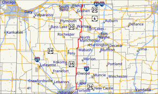
Pigeon River Fish and Wildlife Area is a protected area that covers 12,134 acres (4,910 ha) and is dedicated to providing hunting and fishing opportunities. The area includes 529 acres (214 ha) of lakes and 17 miles (27 km) along the Pigeon River. It is located on Indiana State Road 3, near Mongo in Lagrange County, Indiana. The Fish and Wildlife Area contains Tamarack Bog Nature Preserve, a 150-acre (61 ha) wetland parcel that has been designated as a National Natural Landmark.
J.E. Roush Fish and Wildlife Area is an area dedicated to providing hunting and fishing opportunities while maintaining 8,217 acres (3,325 ha), 870 acres (350 ha) of which are water of J.E. Roush Lake. It is located along U.S. Route 224 east of Huntington, Indiana. Water levels of the flood control reservoir are maintained by the U.S. Army Corps of Engineers.