Trier (region)

Last updated
Trier
Regierungsbezirk Trier
Rhineland-Palatinate Regierungsbezirk Trier (1974-1999).svg
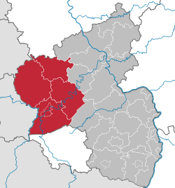
Regierungsbezirk Trier (1974-1999) in Rhineland-Palatinate
Country Germany
State Rhineland-Palatinate
Disestablished2000-01-01
Region seat Trier
Area
  Total4,922.46 km2 (1,900.57 sq mi)
Population
  Total512,990
  Density100/km2 (270/sq mi)
GDP
[1]
  Total€17.741 billion (2021)

Trier was one of the three Regierungsbezirke of Rhineland-Palatinate, Germany, located in the west of the state.

History

The region was created in 1815 as part of the Prussian Rhineland. Until 1920 the bulk of what then became the Territory of Saar Basin was part of the Trier Region. Only the east of the Saar Territory, today's Saar-Palatinate district, formerly the western fringes of the then Bavarian Rhenish Palatinate, was previously no part of the Trier Region. In April 1937 the St. Wendel-Baumholder district, formed in 1920 from those parts of the St. Wendel district that had not been seceded to the Saar Territory, was dissected from the Trier Region and merged in the new Birkenfeld district within the Koblenz Region.

After the Second World War the French military government several times extended the Saar area before forming the Saar Protectorate, also including additional 109 municipalities belonging until July 1946 to the Trier Region and some to the Koblenz Region. Koblenz Region's former areas make up part of today's St. Wendel district in the Saarland. In December 1946, when a new customs boundary dissected the Saar Protectorate (later becoming the Saarland) from the area under the Allied Control Council over Allied-occupied Germany, the Trier Region with its then remaining territory had become one of the then five regions forming the new state of Rhineland-Palatinate, founded in August 1946. Later, the French occupation government again redeployed some municipalities – some returned to Allied-occupied Germany, some newly annexed to the protectorate – between the Saar area and the new state of Rhineland-Palatinate in 1947 and 1949, before the border was finally fixed.

Since 2000, the employees and assets of the Bezirksregierungen (i.e. regional administrations) form the Aufsichts- und Dienstleistungsdirektion Trier (ADD; Supervisory and Service Directorate Trier) and the Struktur- und Genehmigungsdirektionen (SGD; Structural and Approval Directorates) Nord in Koblenz and Süd in Neustadt (Weinstraße). These administrations execute their authority over the whole state, i. e. the ADD Trier oversees all schools.

Related Research Articles

<span class="mw-page-title-main">Rhineland-Palatinate</span> State in Germany

Rhineland-Palatinate is a western state of Germany. It covers 19,846 km2 (7,663 sq mi) and has about 4.05 million residents. It is the ninth largest and sixth most populous of the sixteen states. Mainz is the capital and largest city. Other cities are Ludwigshafen am Rhein, Koblenz, Trier, Kaiserslautern, Worms and Neuwied. It is bordered by North Rhine-Westphalia, Saarland, Baden-Württemberg and Hesse and by France, Luxembourg and Belgium.

<span class="mw-page-title-main">Saarland</span> State in Germany

Saarland is a state of Germany in the southwest of the country. With an area of 2,570 km2 (990 sq mi) and population of 990,509 in 2018, it is the smallest German state in area apart from the city-states of Berlin, Bremen, and Hamburg, and the smallest in population apart from Bremen. Saarbrücken is the state capital and largest city; other cities include Neunkirchen and Saarlouis. Saarland is mainly surrounded by the department of Moselle in France to the west and south and the neighboring state of Rhineland-Palatinate in Germany to the north and east; it also shares a small border about 8 kilometres long with the canton of Remich in Luxembourg to the northwest.

<span class="mw-page-title-main">Palatinate (region)</span> Historical region of Germany

The Palatinate, or the Rhenish Palatinate (Rheinpfalz), is a historical region of Germany. Prior to World War II, it was also referred to as Rhenish Bavaria; as a state of the Holy Roman Empire, it was known as the Lower Palatinate (Unterpfalz), which designated only the western part of the Electorate of the Palatinate, as opposed to the Upper Palatinate (Oberpfalz). It occupies roughly the southernmost quarter of the German federal state of Rhineland-Palatinate (Rheinland-Pfalz), covering an area of 2,105 square miles (5,450 km2) with about 1.4 million inhabitants. Its residents are known as Palatines (Pfälzer).

<span class="mw-page-title-main">Rhineland</span> Historic region of Germany

The Rhineland is a loosely defined area of Western Germany along the Rhine, chiefly its middle section.

<span class="mw-page-title-main">Koblenz (region)</span> Regierungsbezirk in Rhineland-Palatinate, Germany

Koblenz was one of the - at last - three Regierungsbezirke of Rhineland-Palatinate, Germany, located in the north-east of the state.

Birkenfeld is a district (Landkreis) in Rhineland-Palatinate, Germany. Its seat is the town of Birkenfeld. It is bounded by the districts of Sankt Wendel (Saarland), Trier-Saarburg, Bernkastel-Wittlich, Rhein-Hunsrück, Bad Kreuznach and Kusel.

Sankt Wendel is a Kreis (district) in the north of the Saarland, Germany. Neighboring districts are Trier-Saarburg, Birkenfeld, Kusel, Neunkirchen, Saarlouis, and Merzig-Wadern.

Trier-Saarburg is a district in the west of Rhineland-Palatinate, Germany. Neighboring districts are Bitburg-Prüm, Bernkastel-Wittlich, Birkenfeld, Sankt Wendel (Saarland), and Merzig-Wadern (Saarland). To the west it borders Luxembourg. The district-free city Trier is surrounded by the district.

<span class="mw-page-title-main">Sarre (department)</span>

Sarre was a department in the First French Republic and First French Empire. Its territory is now part of Germany and Belgium. Named after the river Saar, it was created in 1798 in the aftermath of the Treaty of Campo Formio of 18 October 1797 which ceded the left bank of the Rhine to France.

<span class="mw-page-title-main">Saar Protectorate</span> French protectorate, disputed territory

The Saar Protectorate, officially Saarland, was a French protectorate and a disputed territory separated from Germany. On joining the Federal Republic of Germany in 1957, it became the smallest "federal state", the Saarland, not counting the "city states" of Berlin, Hamburg, and Bremen. It is named after the Saar River.

<span class="mw-page-title-main">Rhine Province</span> Former province of the Kingdom of Prussia and the Free State of Prussia

The Rhine Province, also known as Rhenish Prussia or synonymous with the Rhineland, was the westernmost province of the Kingdom of Prussia and the Free State of Prussia, within the German Reich, from 1822 to 1946. It was created from the provinces of the Lower Rhine and Jülich-Cleves-Berg. Its capital was Koblenz and in 1939 it had 8 million inhabitants. The Province of Hohenzollern was militarily associated with the Oberpräsident of the Rhine Province. Also, for a short period of time, the Province of Hohenzollern was indirectly and de-facto controlled by the Rhine Province.

<span class="mw-page-title-main">Greater Region of SaarLorLux</span> Euroregion in Western Europe

The Greater Region, formerly also known as SaarLorLux, is a euroregion of eleven regional authorities located in four European states. The term has also been applied to cooperations of several of these authorities or of their subdivisions, administrations, organisations, clubs and people. Member regions represent different political structures: the Walloon region, comprising the French and German-speaking Communities of Belgium; the former Lorraine part of Grand Est, a region of France, including the French departments Meurthe-et-Moselle, Meuse, Moselle and Vosges; the German federated states of Rhineland-Palatinate and Saarland; and the sovereign state of Luxembourg.

<span class="mw-page-title-main">Coat of arms of Saarland</span> Coat of arms of the German state of Saarland

This article is about the coat of arms of the German state of Saarland.

<span class="mw-page-title-main">Freudenburg</span> Municipality in Rhineland-Palatinate, Germany

Freudenburg is a municipality in the Trier-Saarburg district, in Rhineland-Palatinate, Germany. Freudenburg is twinned with the village of Appoigny in France.

<span class="mw-page-title-main">Principality of Lichtenberg</span> Former state in present-day Germany

The Principality of Lichtenberg on the Nahe River was an exclave of the Duchy of Saxe-Coburg-Saalfeld from 1816 to 1826 and the Duchy of Saxe-Coburg and Gotha from 1826 to 1834, when it was sold to the Kingdom of Prussia. Today its territories lie in two States of Germany: the District of St. Wendel in Saarland and the District of Birkenfeld in Rhineland-Palatinate.

<span class="mw-page-title-main">Saar Railway</span> Railway in Germany

The Saarbrücken–Trier railway, known in German as the Saarstrecke in the German states of Rhineland-Palatinate and Saarland. It connects Saarbrücken and Trier. It was opened in 1858 and 1860 and is one of the oldest railways in Germany.

The Circle of the Rhine or Rhine Circle, sometimes the Bavarian Rheinkreis, was the name given to the territory on the west bank of the Rhine from 1816 to 1837 which was one of 15 administrative districts of the Kingdom of Bavaria. Before the French revolutionary wars (1792) most of the land had belonged to the Electoral Palatinate. At the Congress of Vienna in 1815 it was initially promised to the Austrian Empire after having been under a provisional joint Austro-Bavarian administration since 1814. However, in the Treaty of Munich (1816), Austria relinquished the territory to Bavaria.

<span class="mw-page-title-main">Saar-Hunsrück Nature Park</span>

The Saar-Hunsrück Nature Park was established in 1980 and covers an area of just under 2,000 km² in the German states of Rhineland-Palatinate and the Saarland.

<span class="mw-page-title-main">Dollberg</span>

The Dollberg is a mountain in the Dollberge range in central Germany and the highest point in the state of Saarland. It is 695.4 m above sea level (NHN) and lies within the Schwarzwälder Hochwald on the boundary between the counties of Trier-Saarburg (Rhineland-Palatinate) and St. Wendel (Saarland).

<span class="mw-page-title-main">French occupation zone in Germany</span> Zone of French occupation in postwar Germany

The French occupation zone in Germany was one of the Allied-occupied areas in Germany after World War II.

References

  1. "EU regions by GDP, Eurostat" . Retrieved 18 September 2023.

49°46′36″N06°38′00″E / 49.77667°N 6.63333°E / 49.77667; 6.63333