Three Peaks may refer to:
Chimney Rock can refer to one of the following sites in the United States and Canada:
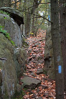
The Metacomet Trail is a 62.7-mile (100.9 km) Blue-Blazed hiking trail that traverses the Metacomet Ridge of central Connecticut and is a part of the newly designated New England National Scenic Trail. Despite being easily accessible and close to large population centers, the trail is considered remarkably rugged and scenic. The route includes many areas of unique ecologic, historic, and geologic interest. Notable features include waterfalls, dramatic cliff faces, woodlands, swamps, lakes, river flood plain, farmland, significant historic sites, and the summits of Talcott Mountain and the Hanging Hills. The Metacomet Trail is maintained largely through the efforts of the Connecticut Forest and Park Association.

Mount Washington State Forest is a publicly owned forest with recreational and scenic features covering 4,619 acres (1,869 ha) in the town of Mount Washington, Massachusetts. The forest conjoins with New York state and the state of Connecticut in the southern Taconic Mountains of the southwestern Berkshire region of Massachusetts. Bash Bish Falls State Park lies adjacent to the state forest. The forest is managed by the Massachusetts Department of Conservation and Recreation.

Lamentation Mountain, or Mount Lamentation, 720 feet (220 m), is a traprock mountain located 2.5 miles (4.0 km) north of Meriden, Connecticut. It is part of the narrow, linear Metacomet Ridge that extends from Long Island Sound near New Haven, Connecticut, north through the Connecticut River Valley of Massachusetts to the Vermont border. Lamentation Mountain is known for its scenic vistas, extensive cliff faces, unique microclimate ecosystems, and rare plant communities. It rises steeply 550 feet (170 m) above the city of Meriden to the south with west-facing cliffs of 200 feet (61 m) or more. The cliff line, described by the Connecticut Forest and Park Association as "perhaps the most scenic traprock ridge walk in the state" is a prominent landscape feature visible for miles. The mountain is traversed by the 50-mile (80 km) Mattabesett Trail.
Talcott Mountain of central Connecticut, with a high point of 950 feet (290 m), is a 13-mile (21 km) long trap rock mountain ridge located 6 miles (10 km) west of the city of Hartford. The ridge, a prominent landscape feature, forms a continuous line of exposed western cliffs visible across the Farmington River valley from Farmington to Simsbury. Talcott Mountain is part of the narrow, linear Metacomet Ridge that extends from Long Island Sound near New Haven, Connecticut, north through the Connecticut River Valley of Massachusetts to the Vermont border.

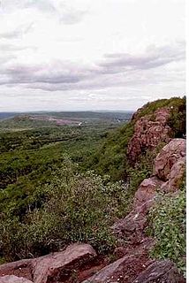
The Metacomet Ridge, Metacomet Ridge Mountains, or Metacomet Range of southern New England is a narrow and steep fault-block mountain ridge known for its extensive cliff faces, scenic vistas, microclimate ecosystems, and rare or endangered plants. The ridge is an important recreation resource located within 10 miles (16 km) of more than 1.5 million people, offering four long-distance hiking trails and over a dozen parks and recreation areas, including several historic sites. It has been the focus of ongoing conservation efforts because of its natural, historic, and recreational value, involving municipal, state, and national agencies and nearly two dozen non-profit organizations.

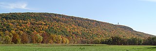
The Holyoke Range or Mount Holyoke Range is a traprock mountain range located in the Connecticut River Valley of Massachusetts. It is a sub-range of the narrow, linear Metacomet Ridge that extends from Long Island Sound near New Haven, Connecticut north through the Connecticut River Valley of Massachusetts to the Vermont border. A popular hiking destination, the range is known for its anomalous east–west orientation, high ledges and its scenic character. It is also notable for its unique microclimate ecosystems and rare plant communities, as well as significant historic sites, such as the Mount Holyoke Summit House and the Horse Caves.
The Mattabesett Trail is a 62-mile (100 km) long, hook-shaped Blue-Blazed hiking trail in central Connecticut and a part of the New England National Scenic Trail. One half of the trail follows the high traprock ridges of the Metacomet Ridge, from Totoket Mountain in Guilford, Connecticut to Lamentation Mountain in Meriden, Connecticut from south to north. This ridge is known for its biodiversity, miles of scenic cliffs, and rugged hiking. The second half of the trail extends north from Guilford to Middletown, Connecticut and ends at the Connecticut River. Here, the trail follows an upland of metamorphic rock with occasional views and dense forests.

Trimountain or Tri-mountain, est. 760 feet (230 m), is a traprock mountain located 6 miles (10 km) southeast of Meriden, Connecticut. It is part of the narrow, linear Metacomet Ridge that extends from Long Island Sound near New Haven, Connecticut, north through the Connecticut River Valley of Massachusetts to the Vermont border. Trimountain is known for its scenic cliff faces, unique microclimate ecosystems, and rare plant communities. The mountain is traversed by the 51-mile (82 km) Mattabesett Trail.

Totoket Mountain, with a high point of (est.) 720 feet (220 m) above sea level, is a traprock massif with several distinct summits, located 7 miles (11 km) northeast of New Haven, Connecticut. It is part of the Metacomet Ridge that extends from the Long Island Sound near New Haven, north through the Connecticut River Valley of Massachusetts to the Vermont border. Totoket Mountain is known for its 500-foot-high (150 m) scenic cliffs, unique microclimate ecosystems, rare plant communities, and for Lake Gaillard, a 2.5-mile-wide (4.0 km) public reservoir nearly enclosed by the mountain. The north ridge of Totoket Mountain is traversed by the 50-mile (80 km) Mattabesett Trail and a significant network of shorter trails. The name "Totoket Mountain" applies to both the entire mountain and to a subordinate northwestern peak.
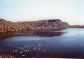
Chauncey Peak, 688 feet (210 m), is a traprock mountain located 2 miles (3 km) northeast of the center of Meriden, Connecticut. It is part of the narrow, linear Metacomet Ridge that extends from Long Island Sound near New Haven, Connecticut, north through the Connecticut River Valley of Massachusetts to the Vermont border. Chauncey Peak is known for its scenic vistas, vertical cliff faces overlooking Crescent Lake, unique microclimate ecosystems, and rare plant communities. It rises steeply 400 feet (120 m) above the city of Meriden to the south with west-facing cliffs that plunge into Crescent Lake 300 feet (91 m) below. The mountain is traversed by the 50-mile (80 km) Mattabesett Trail.

Peak Mountain, also called Copper Mountain, est. 730 feet (220 m), is a traprock mountain located in East Granby, Connecticut, 6 miles (10 km) south of the Massachusetts border and 6 miles west of the Connecticut River. It is part of the narrow, linear Metacomet Ridge that extends from Long Island Sound near New Haven, Connecticut, north through the Connecticut River Valley of Massachusetts to the Vermont border. Peak Mountain is known for its expansive views from 200 feet (61 m) high cliffs overlooking the historic Old Newgate Prison, Congamond Lake, and the Salmon Brook Valley of north-central Connecticut. The mountain is also known for its microclimate ecosystems, rare plant communities, and as a seasonal raptor migration path. It is traversed by the 51-mile (82 km) Metacomet Trail.
Besek Mountain also known as Black Mountain, est. 840 feet (260 m), is a traprock mountain ridge located 4.75 miles (7.6 km) southeast of Meriden, Connecticut. It is part of the narrow, linear Metacomet Ridge that extends from Long Island Sound near New Haven, Connecticut, north through the Connecticut River Valley of Massachusetts to the Vermont border. Besek Mountain is known for its 3-mile (4.8 km) long line of open cliffs, unique microclimate ecosystems, and rare plant communities. The mountain is traversed by the 51-mile (82 km) Mattabesett Trail, and is home to the Powder Ridge Ski Area.
Higby Mountain or Mount Higby 892 feet (272 m), is a traprock mountain ridge located 3.75 miles (6.04 km) east of Meriden, Connecticut. It is part of the narrow, linear Metacomet Ridge that extends from Long Island Sound near New Haven, Connecticut, north through the Connecticut River Valley of Massachusetts to the Vermont border. Higby Mountain is known for its high cliff faces, unique microclimate ecosystems, and rare plant communities. It rises steeply 600 feet (180 m) above the Quinnipiac River valley and the city of Meriden to the west as a continuous 2-mile (3 km) long ledge. The mountain is traversed by the 50-mile (80 km) Mattabesett Trail.

The Weeks Estate is a historic country estate on U.S. Route 3 in Lancaster, New Hampshire. Built in 1912 for John Wingate Weeks, atop Prospect Mountain overlooking the Connecticut River, it is one of the state's best preserved early 20th-century country estates. It was given to the state by Weeks' children, and is now Weeks State Park. It features hiking trails, expansive views of the countryside from the stone observation tower, and a small museum in the main estate house. A small portion of property at the mountain summit was listed on the National Register of Historic Places in 1985.
Tri-Mountain State Park is an isolated public recreation area located in the towns of Wallingford and Durham, Connecticut. The state park encompasses portions of Fowler Mountain and Trimountain. With no road access, the park can only be reached via the Mattabesett Trail. The park originated in 1925 after Wallingford resident John B. Kendrick donated a six-acre parcel on the summit of Trimountain's southern peak that he had purchased for protective purposes in 1906.