
Kodiak Island is a large island on the south coast of the U.S. state of Alaska, separated from the Alaska mainland by the Shelikof Strait. The largest island in the Kodiak Archipelago, Kodiak Island is the second largest island in the United States and the 80th largest island in the world, with an area of 9,311.24 km2 (3,595.09 sq mi), slightly larger than Cyprus. It is 160 km long and in width ranges from 16 to 97 kilometers. Kodiak Island is the namesake for Kodiak Seamount, which lies off the coast at the Aleutian Trench. The largest community on the island is the city of Kodiak, Alaska.
The Kodiak Archipelago is an archipelago, or group of islands, south of the main land mass of the state of Alaska, about 405 km (252 mi) by air south of Anchorage in the Gulf of Alaska. The largest island in the archipelago is Kodiak Island, the second largest island in the United States. The archipelago is about 285 km (177 mi) long and 108 km (67 mi) across, from the Barren Islands on the north to Chirikof Island and the Semidi Islands group on the south. The Archipelago contains 13,890 km2 (5,360 sq mi) of land. The Kodiak Archipelago contains about 40 small glaciers, numerous streams and many species of land and marine animals. Much of its land is forested.

The Kodiak bear, also known as the Kodiak brown bear, sometimes the Alaskan brown bear, inhabits the islands of the Kodiak Archipelago in southwest Alaska. It is the largest recognized subspecies of brown bear, and one of the two largest bears alive today, the other being the polar bear.

Split Island is an uninhabited island in Qikiqtaaluk Region, Nunavut, Canada. Located in Hudson Bay, it belongs to the North Belcher Islands, a sub-archipelago of the Belcher Islands group.
Sitkinak Island is an island of the Kodiak Archipelago of the state of Alaska, United States. It lies south of the southern tip of Kodiak Island in the western part of the Gulf of Alaska. Tugidak Island lies to its west. The two islands are the largest components of the Trinity Islands of Alaska. The Trinity Islands, and thus Sitkinak, are part of the Gulf of Alaska unit of Alaska Maritime National Wildlife Refuge. Sitkinak Island has a land area of 235.506 km² and no resident population.
Tugidak Island is an island of the Kodiak Archipelago in Kodiak Island Borough, Alaska, United States. It lies southwest of the southern tip of Kodiak Island in the western part of the Gulf of Alaska. Sitkinak Island lies to its east. The two islands are the largest components of the Trinity Islands of Alaska. The Trinity Islands, and thus Tugidak, are part of the Gulf of Alaska unit of Alaska Maritime National Wildlife Refuge. Tugidak Island has a land area of 173.142 km² and no resident population. The most prominent feature of the island is the large shallow lagoon near its northeastern end. This part of the island was established as the Tugidak Island Critical Habitat Area by the state of Alaska in 1998 as a wildlife conservation area, and is managed by the Alaska Department of Fish and Game. The island has historically been known as a nesting spot for harbor seals as well as many species of marine birds.

Spruce Island is an island in the Kodiak Archipelago of the Gulf of Alaska in the US state of Alaska. It lies just off the northeast corner of Kodiak Island, across the Narrow Strait. Spruce Island has a land area of 46.066 km² and a population of 242 as of the 2000 census, mostly in its only city, Ouzinkie, in the southwestern part of the island.
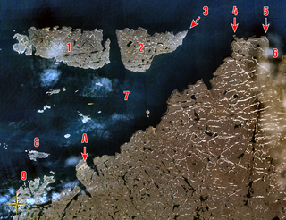
The Semidi Islands are a group of islands of the state of Alaska, United States, lying offshore in the Gulf of Alaska. The islands are part of Kodiak Island Borough and are located southwest of Kodiak Island, about halfway between the Alaska Peninsula mainland and Chirikof Island. The largest islands of the group are Aghiyuk Island and Chowiet Island. The island group has a total land area of 30.178 km² and is uninhabited. They are part of the Alaska Peninsula unit of the Alaska Maritime National Wildlife Refuge.
The uninhabited Stockport Islands are members of the Canadian Arctic Archipelago in the territory of Nunavut. They are located in Bathurst Inlet, east of Daniel Moore Bay, and south of Lewes Island.
Uganik Island is an island lying just off the west coast of Kodiak Island in the Kodiak Archipelago of Alaska, United States. The island has a land area of 146.7 km² and is uninhabited. However, salmon setnetters occupy fish camp sites along the island shore from June–September each year. The island comprises part of the Kodiak National Wildlife Refuge. Hunting and fishing are allowed seasonally, with a proper license.
The uninhabited Nuvuk Islands, members of the Canadian Arctic Archipelago, are located in the Hudson Bay, at the western outlet of Digges Sound, just west of the Ungava Peninsula. The island group is a part of the Qikiqtaaluk Region, in the Canadian territory of Nunavut.
The Wollaston Islands are uninhabited members of the Canadian Arctic Archipelago in the territory of Nunavut. Located on the east side of the mouth of Navy Board Inlet, the island group is closer to Bylot Island than to Baffin Island.
Harper Islands is a small uninhabited island group with an area of 8 km2 (3.1 sq mi), which is part of the Baffin Island group located in the Canadian Arctic Archipelago in the territory of Nunavut. The group lies at the confluence of Frobisher Bay and the Labrador Sea. Other islands also in the immediate vicinity of the tip of Hall Peninsula, but further north, include Lefferts, Bear, Little Hall, and Hudson islands.
The Hozier Islands are a Baffin Island offshore island group located in the Canadian Arctic Archipelago in the territory of Nunavut's Qikiqtaaluk Region. The uninhabited island group lies in the Labrador Sea, east of Hall Peninsula. The Leybourne Islands are 5 km (3.1 mi) to the north.
Hat Island is an uninhabited island located in the Qikiqtaaluk Region of Nunavut, Canada. It is situated in Eureka Sound at the confluence of Bay Fjord, east of Ellesmere Island's Raanes Peninsula, and 19.6 km (12.2 mi) west of Stor Island. It is a member of the Sverdrup Islands group and the Canadian Arctic Archipelago. It is also a member of the Queen Elizabeth Islands and the Canadian Arctic Archipelago.
Cake Island is an uninhabited island in the Qikiqtaaluk Region, Nunavut, Canada. Located in Hudson Bay, it is a member of the Bakers Dozen Islands archipelago of the Belcher Islands group. Other islands in the immediate vicinity include:
Bun Island is an uninhabited island in the Qikiqtaaluk Region, Nunavut, Canada. Located in Hudson Bay, it is a member of the Bakers Dozen Islands archipelago of the Belcher Islands group. Other islands in the immediate vicinity include:
The Barren Islands are an archipelago in Alaska in the United States. They are the northernmost islands of the Kodiak Archipelago. The largest island of the group is Ushagat Island. The islands have a combined land area of 16.23 square miles and are uninhabited. The largest breeding grounds of seabirds in Alaska are located in the Barren Islands on East Amatuli Island and Nord Island. The archipelago is part of the Alaska Maritime National Wildlife Refuge.
