
Kenai Peninsula Borough is a borough of the U.S. state of Alaska. As of the 2010 census, the population was 55,400. The borough seat is Soldotna.
Kodiak Island Borough is a borough in the U.S. state of Alaska. At the 2010 census, the population was 13,592. The borough seat is Kodiak.

Lake and Peninsula Borough is a borough in the state of Alaska. As of the 2010 census, the population was 1,631. The borough seat of King Salmon is located in neighboring Bristol Bay Borough, although is not the seat of that borough. The most populous community in the borough is the city of Newhalen. With an average of 0.0296 inhabitants/km2, the Lake and Peninsula Borough is the second least densely populated organized county-equivalent in the United States; only the unorganized Yukon-Koyukuk Census Area has a lower density.

Northwest Arctic Borough is a borough located in the U.S. state of Alaska. As of the 2010 census, the population was 7,523. The borough seat is Kotzebue. The borough was formed on June 2, 1986.

Akhiok is a second-class city in Kodiak Island Borough, Alaska, United States. Akhiok is Kodiak's southernmost village. The population was 71 at the 2010 census. Akhiok, which does not have a post office, is a rural location in postal code 99615 that belongs to Kodiak. The village is sometimes called Alitak, after a nearby bay.

Afognak is an island in the Kodiak Archipelago 5 km (3.1 mi) north of Kodiak Island in the U.S. state of Alaska. It is 43 miles (69 km) long from east to west and 23 miles (37 km) wide from north to south and has a land area of 1,812.58 km2 (699.84 sq mi), making it the 18th largest island in the United States. The coast is split by many long, narrow bays. The highest point is 2,546 feet (776 m).

The Kodiak Archipelago is an archipelago south of the main land-mass of the state of Alaska, about 405 km (252 mi) by air south-west of Anchorage in the Gulf of Alaska. The largest island in the archipelago is Kodiak Island, the second-largest island in the United States. The archipelago has a length of about 285 km (177 mi) and a width of about 108 km (67 mi), from the Barren Islands on the north to Chirikof Island and the Semidi Islands group on the south. The archipelago contains 13,890 km2 (5,360 sq mi) of land. The Kodiak Archipelago contains about 40 small glaciers, numerous streams and many species of land and marine animals. Much of its land is forested.

The Alaska Peninsula is a peninsula extending about 800 km (497 mi) to the southwest from the mainland of Alaska and ending in the Aleutian Islands. The peninsula separates the Pacific Ocean from Bristol Bay, an arm of the Bering Sea.

The Kodiak bear, also known as the Kodiak brown bear, sometimes the "Alaskan brown bear", inhabits the islands of the Kodiak Archipelago in southwest Alaska. It is the largest recognized subspecies or population of the brown bear, and one of the two largest bears alive today, the other being the polar bear.

Southwest Alaska is a region of the U.S. state of Alaska. The area is not exactly defined by any governmental administrative region(s); nor does it always have a clear geographic boundary.

Sitkinak Island is an island of the Kodiak Archipelago of the state of Alaska, United States. It lies south of the southern tip of Kodiak Island in the western part of the Gulf of Alaska. Tugidak Island lies to its west. The two islands are the largest components of the Trinity Islands of Alaska. The Trinity Islands, and thus Sitkinak, are part of the Gulf of Alaska unit of Alaska Maritime National Wildlife Refuge. Sitkinak Island has a land area of 235.506 km2 and no resident population.
The Semidi Islands are a group of islands of the state of Alaska, United States, lying offshore in the Gulf of Alaska. The islands are part of Kodiak Island Borough and are located southwest of Kodiak Island, about halfway between the Alaska Peninsula mainland and Chirikof Island. The largest islands of the group are Aghiyuk Island and Chowiet Island. The island group has a total land area of 30.178 km2 and is uninhabited. They are part of the Alaska Peninsula unit of the Alaska Maritime National Wildlife Refuge.
Whale Island is an island of the Kodiak Archipelago in the Gulf of Alaska in Kodiak Island Borough, Alaska, United States. It lies off the northern end of Kodiak Island, between it and Afognak Island to the north. It is separated from Kodiak Island by Whale Pass, and from Afognak Island by Afognak Strait. Raspberry Island lies to the west, while Spruce Island lies to the east. Whale Island has a land area of 39.235 km2 and is unpopulated.
Marmot Island is an island of the Kodiak Archipelago in the Gulf of Alaska in the U.S. state of Alaska. It is part of Kodiak Island Borough and lies east of Afognak Island. The island has a land area of 45.196 km2 and is unpopulated.

Shuyak Island is an island in the northern part of the Kodiak Archipelago in the state of Alaska, USA. It is located just north of Afognak Island, separated from it by the narrow Shuyak Strait. The Stevenson Entrance to Cook Inlet separates it from the Barren Islands further north in the archipelago. The island has an area of 168.3 km2 and reported an official population of four persons at the 2000 census. Alaska's Shuyak Island State Park comprises most of the island's territory. The island's current major industry is tourism based on camping, recreational fishing, hunting, and kayaking. In the past the island was home to a large fish processing plant at Port William, but that industry has since declined with the advent of factory ships.
Uganik Island is an island lying just off the west coast of Kodiak Island in the Kodiak Archipelago of Alaska, United States. The island has a land area of 146.7 km2 and is uninhabited. However, salmon setnetters occupy fish camp sites along the island shore from June–September each year. The island comprises part of the Kodiak National Wildlife Refuge. Hunting and fishing are allowed seasonally, with a proper license.
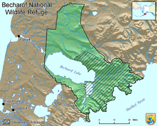
Becharof National Wildlife Refuge is a National Wildlife Refuge in the Aleutian Range of the Alaska Peninsula of southwestern Alaska. It is adjacent to Katmai National Park and Preserve. This national wildlife refuge, which covers an area of 1,200,000 acres (4,900 km2), was established in 1980 to conserve major brown bears, salmon, migratory birds, caribou, marine birds, and mammals and to comply with treaty obligations. It lies primarily in the east-central part of Lake and Peninsula Borough, but extends eastward into the mainland portion of Kodiak Island Borough. The refuge is administered from offices in King Salmon.

Afognak Island State Park is a 75,047-acre (30,370 ha) Alaska state park on Afognak Island in Kodiak Island Borough, Alaska in the United States. Afognak Island is northeast of Kodiak Island on the Alaska Peninsula. Most of Afognak Island State Park is undeveloped. The park is known for its rugged topography and wide variety of wildlife. Afognak Island State Park is open to year-round recreation, including fishing, hunting, and hiking. Transportation is provided by float plane from Kodiak to various areas around the park. It is on the northern and eastern ends of the island and surrounds Perenosa, Seal and Tonki Bays. It borders part of Kodiak National Wildlife Refuge to the west.
The Barren Islands (Sugpiaq: Usu'unaat) are an archipelago in Alaska in the United States. They are the northernmost islands of the Kodiak Archipelago. The largest island of the group is Ushagat Island. The islands have a combined land area of 16.23 square miles (42.03 km²) and are uninhabited. The largest breeding grounds of seabirds in Alaska are located in the Barren Islands on East Amatuli Island and Nord Island. The archipelago is part of the Alaska Maritime National Wildlife Refuge.
Sandy Lake is a lake on the Alaska Peninsula. The lake is located between the Upper Sandy River and Lower Sandy River, which drains into the Bering Sea. It lies 25 miles north-east of Port Moller Airport and is on the boundary of the Alaska Peninsula National Wildlife Refuge. Mount Veniaminof lies to the west of the lake.

