
Kodiak Island Borough is a borough in the U.S. state of Alaska. At the 2020 census, the population was 13,101, down from 13,592 in 2010. The borough seat is Kodiak.
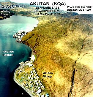
Akutan is a city on Akutan Island in the Aleutians East Borough of the Aleutian Islands in Alaska, United States. The population was 1,589 at the 2020 census, up from 1,027 in 2010, making it the 4th fastest-growing city of the decade in Alaska. Akutan Harbor is adjacent.

Karluk is a census-designated place (CDP) in Kodiak Borough, Kodiak Island, Alaska, United States. The population was 37 at the 2010 census, up from 27 in 2000.

Kodiak Island is a large island on the south coast of the U.S. state of Alaska, separated from the Alaska mainland by the Shelikof Strait. The largest island in the Kodiak Archipelago, Kodiak Island is the second largest island in the United States and the 80th largest island in the world, with an area of 3,595.09 sq mi (9,311.2 km2), slightly larger than Cyprus. It is 160 km long and in width ranges from 16 to 97 kilometers. Kodiak Island is the namesake for Kodiak Seamount, which lies off the coast at the Aleutian Trench. The largest community on the island is the city of Kodiak, Alaska.

The Gulf of Alaska is an arm of the Pacific Ocean defined by the curve of the southern coast of Alaska, stretching from the Alaska Peninsula and Kodiak Island in the west to the Alexander Archipelago in the east, where Glacier Bay and the Inside Passage are found.

Afognak is an island in the Kodiak Archipelago 5 km (3.1 mi) north of Kodiak Island in the U.S. state of Alaska. It is 43 miles (69 km) long from east to west and 23 miles (37 km) wide from north to south and has a land area of 1,812.58 km2 (699.84 sq mi), making it the 18th largest island in the United States. The coast is split by many long, narrow bays. The highest point is 2,546 feet (776 m).
Shelikof Strait is a strait on the southwestern coast of the U.S. state of Alaska between the Alaska mainland to the west and Kodiak and Afognak islands to the east.
The Kodiak Archipelago is an archipelago south of the main land-mass of the state of Alaska, about 405 km (252 mi) by air south-west of Anchorage in the Gulf of Alaska. The largest island in the archipelago is Kodiak Island, the second-largest island in the United States. The archipelago has a length of about 285 km (177 mi) and a width of about 108 km (67 mi), from the Barren Islands on the north to Chirikof Island and the Semidi Islands group on the south. The archipelago contains 13,890 km2 (5,360 sq mi) of land. The Kodiak Archipelago contains about 40 small glaciers, numerous streams and many species of land and marine animals. Much of its land is forested.
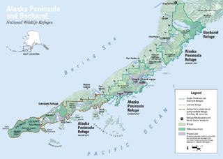
The Alaska Peninsula is a peninsula extending about 497 mi (800 km) to the southwest from the mainland of Alaska and ending in the Aleutian Islands. The peninsula separates the Pacific Ocean from Bristol Bay, an arm of the Bering Sea.

Chirikof Island is located in the Gulf of Alaska approximately 80 miles (130 km) southwest of Kodiak Island.

Southwest Alaska is a region of the U.S. state of Alaska. The area is not exactly defined by any governmental administrative region(s); nor does it always have a clear geographic boundary.

Hinchinbrook Island is an island in the Gulf of Alaska lying at the entrance to Prince William Sound in the state of Alaska, United States. The island has a land area of 171.98 sq mi (445.438 km²), making it the 37th largest island in the United States. There was a population of five permanent residents as of the 2000 census.
Sitkalidak Island is an island in the western Gulf of Alaska in the Kodiak Island Borough of the state of Alaska, United States. It lies just off the southeast shore of Kodiak Island, across the Sitkalidak Strait from the city of Old Harbor. The island has a land area of 300 square kilometers (120 sq mi) and no resident population.

Tugidak Island is an island of the Kodiak Archipelago in Kodiak Island Borough, Alaska, United States. It lies southwest of the southern tip of Kodiak Island in the western part of the Gulf of Alaska. Sitkinak Island lies to its east. The two islands are the largest components of the Trinity Islands of Alaska. The Trinity Islands, and thus Tugidak, are part of the Gulf of Alaska unit of Alaska Maritime National Wildlife Refuge. Tugidak Island has a land area of 173.142 km2 and no resident population. The most prominent feature of the island is the large shallow lagoon near its northeastern end. This part of the island was established as the Tugidak Island Critical Habitat Area by the state of Alaska in 1998 as a wildlife conservation area, and is managed by the Alaska Department of Fish and Game. The island has historically been known as a nesting spot for harbor seals as well as many species of marine birds.
Near Island is an island that comprises part of the city of Kodiak, Alaska, United States. It lies across the Near Island Channel just south of downtown Kodiak. The island is the site of St. Herman Harbor, the newer of Kodiak's two marinas. Near island has a land area of 1.117 km2 and a resident population of six people as of the 2000 census. It is connected to downtown Kodiak by the Near Island Bridge on Dog Bay Road.
The Semidi Islands are a group of islands of the state of Alaska, United States, lying offshore in the Gulf of Alaska. The islands are part of Kodiak Island Borough and are located southwest of Kodiak Island, about halfway between the Alaska Peninsula mainland and Chirikof Island. The largest islands of the group are Aghiyuk Island and Chowiet Island. The island group has a total land area of 30.178 km2 and is uninhabited. They are part of the Alaska Peninsula unit of the Alaska Maritime National Wildlife Refuge.
Marmot Island is an island of the Kodiak Archipelago in the Gulf of Alaska in the U.S. state of Alaska. It is part of Kodiak Island Borough and lies east of Afognak Island. The island has a land area of 45.196 km2 and is unpopulated.

Raspberry Island is an island of the Kodiak Archipelago located in the Gulf of Alaska in the U.S. state of Alaska. It is located two miles northwest of Whale Island, and just across the mile-wide Raspberry Strait from the southwestern end of Afognak. The island is separated from Kodiak Island by the Kupreanof Strait, with the Shelikof Strait to the northwest. Raspberry Island is 18 miles (29 km) long with a width that varies from 3 miles (4.8 km) to 8 miles (12.9 km). The highest point on the island is 3,300 ft.
Cape Alitak is a finger of land on the south side of Kodiak Island, the major island of the Kodiak Archipelago of southern Alaska. The cape is an extension of Tanner Head, from which it is separated by Rodman Reach, a saltwater lagoon. The cape is bounded on the east by Alitak Bay, on the west by the southern end of Shelikof Strait, and on the south by Sitkinak Strait, which separates Kodiak Island from the Trinity Islands. The cape has long been known its remarkable collection of prehistoric petroglyphs, which include a wide variety of shapes, some of animals and humans, and others of apparently abstract geometric figures. The cape was surveyed in detail in 2011 by archaeologists from the Alutiiq Museum in Kodiak, at which time thirteen different petroglyph locations were identified, along with evidence of prehistoric habitation of the area. The petroglyph site were listed on the National Register of Historic Places in 2013.
The Barren Islands (Sugpiaq: Usu'unaat) are an archipelago in Alaska in the United States. They are the northernmost islands of the Kodiak Archipelago. The largest island of the group is Ushagat Island. The islands have a combined land area of 16.23 square miles (42.0 km2) and are uninhabited. The largest breeding grounds of seabirds in Alaska are located in the Barren Islands on East Amatuli Island and Nord Island. The archipelago is part of the Alaska Maritime National Wildlife Refuge.

