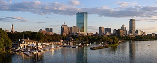
Back Bay is an officially recognized neighborhood of Boston, Massachusetts, built on reclaimed land in the Charles River basin. Construction began in 1859, as the demand for luxury housing exceeded the availability in the city at the time, and the area was fully built by around 1900. It is most famous for its rows of Victorian brownstone homes—considered one of the best preserved examples of 19th-century urban design in the United States—as well as numerous architecturally significant individual buildings, and cultural institutions such as the Boston Public Library, and Boston Architectural College. Initially conceived as a residential-only area, commercial buildings were permitted from around 1890, and Back Bay now features many office buildings, including the John Hancock Tower, Boston's tallest skyscraper. It is also considered a fashionable shopping destination and home to several major hotels.

An indenture is a legal contract that reflects or covers a debt or purchase obligation. It specifically refers to two types of practices: in historical usage, an indentured servant status, and in modern usage, it is an instrument used for commercial debt or real estate transaction.

John Leverett was an English colonial magistrate, merchant, soldier and the penultimate governor of the Massachusetts Bay Colony. Born in England, he migrated to Massachusetts as a teenager. He was a leading merchant in the colony, and served in its military. In the 1640s he went back to England to fight in the English Civil War.

Kenmore station is a light rail station on the MBTA Green Line, located under Kenmore Square in the Fenway/Kenmore neighborhood of Boston, Massachusetts, United States. The station opened on October 23, 1932 as a one-station extension of the Boylston Street subway to relieve congestion in the square. Kenmore is the primary station for passengers wishing to visit Fenway Park, located one block away.

The Back Bay Fens, often called The Fens, is a parkland and urban wild in Boston, Massachusetts, in the United States. It was established in 1879. Designed by Frederick Law Olmsted to serve as a link in the Emerald Necklace park system, the Fens gives its name to the Fenway-Kenmore neighborhood.

Kenmore Square is a square in the Fenway–Kenmore neighborhood of Boston, Massachusetts. It is formed by the crossing of Beacon Street,Commonwealth Avenue, and Brookline Avenue. It is the eastern terminus of U.S. Route 20, the longest U.S. Highway. The Citgo sign is a prominent landmark in Kenmore Square, and Fenway Park is just to the south. Kenmore station is located under the square, with a surface bus terminal inside the square.

The Public Garden, also known as Boston Public Garden, is a large park in the heart of Boston, Massachusetts, adjacent to Boston Common. It is a part of the Emerald Necklace system of parks and is bounded by Charles Street and Boston Common to the east, Beacon Street and Beacon Hill to the north, Arlington Street and Back Bay to the west, and Boylston Street to the south. The Public Garden was the first public botanical garden in America.

The B branch, also called the Commonwealth Avenue branch or Boston College branch, is a branch of the MBTA Green Line light rail system which operates on Commonwealth Avenue west of downtown Boston, Massachusetts. One of four branches of the Green Line, the B branch runs from Boston College station down the median of Commonwealth Avenue to Blandford Street. There, it enters Blandford Street portal into Kenmore station, where it merges with the C and D branches. The combined services run into the Boylston Street subway and Tremont Street subway to downtown Boston. B branch service has terminated at Government Center since October 2021. Unlike the other branches, the B branch runs solely through the city limits of Boston. The Green Line Rivalry between Boston College and Boston University is named in reference to the B branch, which runs to both universities.

The Department of Conservation and Recreation (DCR) is a state agency of the Commonwealth of Massachusetts, United States, situated in the Executive Office of Energy and Environmental Affairs. It is best known for its parks and parkways. The DCR's mission is "To protect, promote and enhance our common wealth of natural, cultural and recreational resources for the well-being of all." The agency is the largest landowner in Massachusetts.

The Framingham/Worcester Line of the MBTA Commuter Rail system runs west from Boston, Massachusetts to Worcester, Massachusetts through the MetroWest region, serving 17 station stops in Boston, Newton, Wellesley, Natick, Framingham, Ashland, Southborough, Westborough, Grafton, and Worcester. It is the third longest and third busiest line in the MBTA Commuter Rail system. Service on the line is a mix of local and express trains serving Worcester plus short-turn Framingham locals.

Boston's diverse neighborhoods serve as a political and cultural organizing mechanism. The City of Boston's Office of Neighborhood Services has designated 23 Neighborhoods in the city:

Uriel Crocker was a public-spirited Boston citizen, head of the Crocker & Brewster publishing house during its 58-year existence (1818-1876), and actively involved in other enterprises including railroads.

Alexander Hamilton Rice was an American politician and businessman from Massachusetts. He served as Mayor of Boston from 1856 to 1857, a U.S. Congressman during the American Civil War, and as the 30th Governor of Massachusetts from 1876–1878. He was part owner and president of Rice-Kendall, one of the nation's largest paper products distributors.

The Toronto Purchase was the sale of lands in the Toronto area from the Mississaugas of New Credit to the British crown. An initial, disputed, agreement was made in 1787, in exchange for various items. The agreement was revisited in 1805, intended to clarify the area purchased. The agreement remained in dispute for over 200 years until 2010, when a settlement for the land was made between the Government of Canada and the Mississaugas for the land and other lands in the area.
Tripartite means composed of or split into three parts, or refers to three parties. Specifically, it may also refer to any of the following:

Grafton State Hospital was a psychiatric hospital in Grafton, Massachusetts that operated from 1901 to 1973. Today, the site has been redeveloped with Tufts University's Cummings School of Veterinary Medicine as a major occupant, along with the Grafton Job Corps office and various other State agencies.
Indo-Grenadians or Grenadians who trace their roots to India, form the largest minority group in Grenada. This term is not generally recognized by Grenadians or indeed Caribbeans. They usually refer to themselves simply as Grenadian or possibly Caribbean. This group was first introduced during the second half of the 19th century when Grenada experimented with indentured labour. By the second half of the 20th century Indians were so integrated into Grenada’s society that a distinct Indian cultural identity was generally invisible. In addition, Indians were involved in every aspect of Grenadian life. Currently there are over 12,000 Grenadians of Indian and mixed-Indian descent.

Andover Town Hall is the historic town hall of Andover, Massachusetts. It is located at 20 Main Street, between Park and Barnard Streets. The 2+1⁄2 story Romanesque Revival red brick building was constructed in 1858, not long after the separation of North Andover. It was designed by Boston architect Theodore Voelkers and built by local builders Abbott & Clement. The building design echoed that of the mills that dotted the town. It was listed on the National Register of Historic Places in 1982.

Amory Street station is a light rail stop on the Massachusetts Bay Transportation Authority (MBTA) Green Line B branch, located in the median of Commonwealth Avenue in the west part of the Boston University campus. The accessible station has two side platforms serving the line's two tracks, with access at Amory Street and St. Paul Street.
The Tripartite Indenture was an agreement made in February 1405 among Owain Glyndŵr, Edmund Mortimer, and Henry Percy, 1st Earl of Northumberland, agreeing to divide England and Wales up among them at the expense of Henry IV. Glyndŵr was to be given Wales, and a substantial part of the west of England, including the English portions of the Welsh Marches. Northumberland was to have received the north, as well as Northamptonshire, Norfolk, Warwickshire, and Leicestershire. The Mortimers were to have received the rest of southern England.