
The Bahamas are a group of about 700 islands and cays in the western Atlantic Ocean, of which only between 30 and 40 are inhabited. The largest of the islands is Andros Island, located north of Cuba and 200 kilometres southeast of Florida. The Bimini islands are to its northwest. To the North is the island of Grand Bahama, home to the second-largest city in the country, Freeport. The island of Great Abaco is to its east. In the far south is the island of Great Inagua, the second-largest island in the country. Other notable islands include Eleuthera, Cat Island, San Salvador Island, Acklins, Crooked Island, and Mayaguana. Nassau is the capital and largest city, located on New Providence. The islands have a tropical savannah climate, moderated by the Gulf Stream. The total size is 13,878 km2 (5,358 sq mi). Due to the many widespread islands it has the 41st largest Exclusive Economic Zone of 654,715 km2 (252,787 sq mi).

The 2004 Atlantic hurricane season was a very deadly, destructive, and hyperactive Atlantic hurricane season, with over 3,200 deaths and more than $61 billion in damage. More than half of the 16 tropical cyclones brushed or struck the United States. Due to the development of a Modoki El Niño – a rare type of El Niño in which unfavorable conditions are produced over the eastern Pacific instead of the Atlantic basin due to warmer sea surface temperatures farther west along the equatorial Pacific – activity was above average. The season officially began on June 1 and ended on November 30, though the season's last storm, Otto, dissipated on December 3, extending the season beyond its traditional boundaries. The first storm, Alex, developed offshore of the Southeastern United States on July 31, one of the latest dates on record to see the formation of the first system in an Atlantic hurricane season. It brushed the Carolinas and the Mid-Atlantic, causing one death and $7.5 million (2004 USD) in damage. Several storms caused only minor damage, including tropical storms Bonnie, Earl, Hermine, and Matthew. In addition, hurricanes Danielle, Karl, and Lisa, Tropical Depression Ten, Subtropical Storm Nicole and Tropical Storm Otto had no effect on land while tropical cyclones.

Hurricane Betsy was an intense and destructive tropical cyclone that brought widespread damage to areas of Florida and the central United States Gulf Coast in September 1965. The storm's erratic nature, coupled with its intensity and minimized preparation time contributed to making Betsy the first tropical cyclone in the Atlantic basin to accrue at least $1 billion in damage. While the storm primarily affected areas of southern Florida and Louisiana, lesser effects were felt in the Bahamas and as far inland in the United States as the Ohio River Valley. Betsy began as a tropical depression north of French Guiana on August 27, and strengthened as it moved in a general northwesterly direction. After executing a slight anticyclonic loop north of the Bahamas, Betsy proceeded to move through areas of south Florida on September 8, causing extensive crop damage. After emerging into the Gulf of Mexico, the cyclone strengthened and reached its peak intensity equivalent to that of a Category 4 hurricane on September 10 before making its final landfall near Grand Isle, Louisiana, shortly thereafter. Once inland, Betsy was slow to weaken, and persisted for two more days before degenerating into an extratropical storm; these remnants lasted until September 13.

The 1992 Atlantic hurricane season was a well below average hurricane season that had one of the latest dates on record for the first named storm. The season officially began on June 1, 1992, and lasted until November 30, 1992. The first storm, an unnamed subtropical storm, developed in the central Atlantic on April 21, over a month before the official start of hurricane season. The most significant storm of the season was Hurricane Andrew, which at the time was the costliest U.S. hurricane. After crossing the Bahamas, the hurricane made landfall in Florida and Louisiana. It caused $27.3 billion in damage, mostly in Florida, and 65 fatalities. Andrew was also the strongest hurricane of the season, reaching winds of 175 mph (282 km/h) while approaching Florida.

The 1983 Atlantic hurricane season was the least active Atlantic hurricane season in 53 years, a significantly below average season during which only four tropical storms formed. The season officially began on June 1, 1983, and lasted until November 30, 1983. These dates conventionally delimit the period of each year when most storms form in the Atlantic basin. The season had very little activity, with only seven tropical depressions, four of which reached tropical storm strength or higher. This led to the lowest Accumulated Cyclone Energy count since 1950, but not since 1900.
Hurricane Isidore or Tropical Storm Isidore may refer to:
The name Frances was used for eight tropical cyclones in the Atlantic Ocean. It was even with Arlene as the most-used Atlantic storm name, but fell to second place when Arlene was used for the first storm of the 2005 season.
The name Arlene has been used for eleven tropical cyclones in the Atlantic Ocean, making Arlene the most frequently used Atlantic storm name.
The name Lili was used for four tropical cyclones in the Atlantic Ocean, one tropical cyclone in the Australian region, and one tropical cyclone in the South Pacific Ocean. Lili is not to be confused with Lily, which was used in the Eastern Pacific Ocean.
The name Irene was used for the following tropical cyclones in the Atlantic and Pacific Oceans.

The 1932 Bahamas hurricane, also known as the Great Abaco hurricane of 1932, was a large and powerful Category 5 hurricane that struck the Bahamas at peak intensity. The fourth tropical storm and third hurricane in the 1932 Atlantic hurricane season, it was also one of two Category 5 hurricanes in the Atlantic Ocean that year, the other being the 1932 Cuba hurricane. The 1932 Bahamas hurricane originated north of the Virgin Islands, became a strong hurricane, and passed over the northern Bahamas before recurving. The storm never made landfall on the continental United States, but its effects were felt in the northeast part of the country and in the Bahamas, especially on the Abaco Islands, where damage was very great. To date, it is one of four Category 5 Atlantic hurricanes to make landfall in the Bahamas at that intensity, the others having occurred in 1933, 1992, and 2019.

Hurricane Katrina was a late-forming tropical cyclone that impacted portions of the Greater Antilles and Bahamas in November 1981. The twenty-first tropical cyclone, eleventh named storm, and seventh hurricane of the 1981 Atlantic hurricane season, Katrina developed from an area of cloudiness in the western Caribbean Sea early on November 3. The initial tropical depression deepened slowly, and was upgraded to Tropical Storm Katrina on November 5. About six hours later, Katrina peaked with sustained winds of 85 mph (140 km/h). The storm made landfall along the south coast of Camagüey Province in Cuba early on November 6. Katrina quickly weakened to a tropical storm, before emerging into the Atlantic Ocean hours later. The system then accelerated northeastward and crossed the Bahamas late on November 6. Katrina dissipated late on November 7, shortly before merging with a frontal system.

Tropical Storm Arlene was a rare off-season tropical cyclone that hit Cuba and the Bahamas in May 1981. Its formation was unusual, originating from a tropical disturbance that crossed from the eastern Pacific Ocean into the Caribbean Sea; few Atlantic hurricanes develop in this manner. On May 6, a tropical depression developed, and the next day it became Tropical Storm Arlene near the Cayman Islands, three weeks before the start of the hurricane season. This marked the first Atlantic tropical storm in May since 1970's Hurricane Alma. Arlene moved northeastward throughout its life, bringing rainfall and locally gusty winds as it crossed Cuba and the southeastern Bahamas. On May 9, the storm dissipated when a large non-tropical storm absorbed Arlene. There were no reports of deaths or significant damage.

The 2014 Atlantic hurricane season was a below average season in terms of named storms, and an average season in terms of both hurricanes and major hurricanes. It produced nine tropical cyclones, eight named storms, the fewest since the 1997 Atlantic hurricane season, six hurricanes and two major hurricanes. It officially began on June 1, 2014, and ended on November 30, 2014. These dates historically describe the period each year when most tropical cyclones form in the Atlantic basin. The first storm of the season, Arthur, developed on July 1, while the final storm, Hanna, dissipated on October 28, about a month prior to the end of the season.

The 1866 Atlantic hurricane season was originally one of only four Atlantic hurricane seasons in which every known tropical cyclone attained hurricane status, along with 1852, 1858, and 1884. Initially, there were three known storms during the season, but a re-analysis confirmed the increased activity. There were also two other systems that were included as tropical cyclones at one time, although both were considered to have been other storms already in the database. All tropical activity occurred between the middle of July and the end of October. There may have been additional unconfirmed tropical cyclones during the season. Meteorologist Christopher Landsea estimates that up to six storms were missed from the official database, due to small tropical cyclone size, sparse ship reports, and relatively unpopulated coastlines.
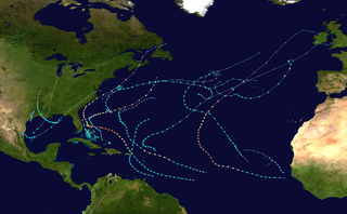
The 2019 Atlantic hurricane season was the fourth consecutive above-average and damaging season since 2016. It is tied with 1969 as the fourth-most active Atlantic hurricane season on record in terms of named storms, with 18 named storms and 20 tropical cyclones in total. However, many were weak and short-lived, especially towards the end of the season. Six of those named storms achieved hurricane status, while three intensified into major hurricanes. Two storms became Category 5 hurricanes, causing the season to become the fourth consecutive season with at least one Category 5 hurricane and the seventh on record to have multiple tropical cyclones reaching that intensity. The season officially began on June 1 and ended on November 30. These dates historically describe the period each year when most tropical cyclones form in the Atlantic basin and are adopted by convention. However, tropical cyclogenesis is possible at other times of the year, as demonstrated by the formation of Subtropical Storm Andrea on May 20, marking the record fifth consecutive year where a tropical or subtropical cyclone developed before the official start of the season.
The 2019 Atlantic hurricane season was an event in the annual tropical cyclone season in the north Atlantic Ocean. It was the fourth consecutive above-normal Atlantic hurricane season. The season officially began on June 1, 2019 and ended on November 30, 2019. These dates, adopted by convention, historically describe the period in each year when most tropical systems form. However, storm formation is possible at any time of the year, as demonstrated in 2019 by the formation of the season's first named storm, Subtropical Storm Andrea, on May 20. The final storm of the season, Tropical Storm Sebastien transitioned to an extratropical cyclone on November 25.

During 2019, tropical cyclones formed within seven different tropical cyclone basins, located within various parts of the Atlantic, Pacific and Indian Oceans. During the year, a total of 150 systems formed with 102 of these developing further and were named by the responsible warning centre. The strongest tropical cyclone of the year was Typhoon Halong, which was estimated to have a minimum barometric pressure of 905 hPa (26.72 inHg). Hurricane Dorian has the highest wind-speed, with 1-minute sustained wind speed of 185 mph (295 km/h).

Hurricane Dorian was an extremely powerful and devastating Category 5 Atlantic hurricane, that became the most intense tropical cyclone on record to strike the Bahamas, and is regarded as the worst natural disaster in the country's history. It was also one of the most powerful hurricanes recorded in the Atlantic Ocean in terms of 1-minute sustained winds, with these winds peaking at 185 mph (295 km/h). In addition, Dorian surpassed Hurricane Irma of 2017 to become the most powerful Atlantic hurricane on record outside of the tropics. It was the fourth named storm, second hurricane, the first major hurricane, and the first Category 5 hurricane of the 2019 Atlantic hurricane season. Dorian struck the Abaco Islands on September 1 with maximum sustained winds of 185 mph (295 km/h), tying with the 1935 Labor Day hurricane for the highest wind speeds of an Atlantic hurricane ever recorded at landfall. Dorian went on to strike Grand Bahama at similar intensity, stalling just north of the territory with unrelenting winds for at least 24 hours. The resultant damage to these islands was catastrophic; most structures were flattened or swept to sea, and at least 70,000 people were left homeless. After it ravaged through the Bahamas, Dorian proceeded along the coasts of the Southeastern United States and Atlantic Canada, leaving behind considerable damage and economic losses in those regions.

Hurricane Dorian was the strongest hurricane to affect the Bahamas on record, causing catastrophic damage in the Abaco Islands and Grand Bahama in early September 2019. The cyclone's intensity as well as its slow forward motion near the Bahamas broke numerous records. The fifth tropical cyclone, fourth named storm, second hurricane, and first major hurricane of the 2019 Atlantic hurricane season, Dorian originated from a westward-traveling tropical wave that departed from the western coast of Africa on August 19. The system organized into a tropical depression and later a tropical storm, both on August 24.