
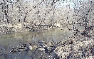
The Lac qui Parle River is a tributary of the Minnesota River, 118 miles (190 km) long, in southwestern Minnesota in the United States. A number of tributaries of the river, including its largest, the West Branch Lac qui Parle River, also flow in eastern South Dakota. Via the Minnesota River, the Lac qui Parle River is part of the watershed of the Mississippi River, draining an area of 1,156 square miles (2,990 km2) in an agricultural region. Slightly more than two-thirds of the Lac qui Parle watershed is in Minnesota. Lac qui parle means "lake which speaks" in the French language, and was a translation of the Sioux name for Lac qui Parle, a lake on the Minnesota River upstream of the mouth of the Lac qui Parle River.

Afton State Park is a state park of Minnesota, USA, on the St. Croix River in Washington County. Its hiking trails offer views of the river, rolling glacial moraine, and bluffland it preserves. It is a popular place for birdwatching, picnics, camping, and other typical outdoor recreational activities. To deter overuse of a state park only 20 miles (32 km) from downtown St. Paul, there is no vehicle access to the camping area or swimming beach.

The Root River flows for 80 miles (130 km) through the Driftless Area of southeastern Minnesota and is a tributary of the Upper Mississippi River. The Root River is formed by three branches, the North, South and Middle branches of the Root River and the South Fork Root River. It is an excellent river for canoeing and fishing. The gentle to moderate flowing river drops an average of 3.4 ft/mile from Chatfield, Minnesota, to its pour point in the Mississippi River into Navigation Pool 7 just south of La Crosse, Wisconsin and east of Hokah, Minnesota.
The Zumbro River is a tributary of the Mississippi River in the Driftless Area of southeastern Minnesota in the United States. It is 64.6 miles (104.0 km) long from the confluence of its principal tributaries and drains a watershed of 1,428 square miles (3,700 km2). The river's name in English is a change from its French name Rivière des Embarras due to its mouth near Pine Island in the Mississippi River; the pronunciation changed from to. The Dakota name for this river is Wapka Wazi Oju, having reference to the grove of great white pines at Pine Island.

Miesville Ravine Park Reserve is a Dakota County park near the town of Miesville, Minnesota, United States. It preserves over 1,600 acres (6 km2) of biologically diverse land in the Cannon River valley. Most of the park is wooded with mature oak, maple, cottonwood, willow, red cedar, and white pine. A trout stream, Trout Brook, is located in the reserve.

The Vermillion River is a 59.6-mile (95.9 km) waterway that meanders through Scott County and Dakota County in Minnesota, entering the Mississippi River floodplain just south of Hastings. 13.5 miles (21.7 km) of it are designated as a trout stream, which is unusual for being so close to a metropolitan area. Trophy-sized trout may be found in the river.

Rice Creek is a tributary of the Mississippi River in the northern suburbs of the Minneapolis–St. Paul metropolitan area of Minnesota in the United States. It is approximately 28 miles (45 km) long and drains a watershed of 201 square miles (520 km2).

The Straight River is a tributary of the Fish Hook River, 23 miles (37 km) long, in the north-central region of the U.S. state of Minnesota. Via the Fish Hook, Shell, and Crow Wing Rivers, it is part of the watershed of the Mississippi River, draining an area of approximately 60 square miles (160 km2) in a rural region. The river is known as one of Minnesota's best trout fishing streams.

The Whitewater River is a 16.6-mile-long (26.7 km) tributary of the Upper Mississippi River which flows through the Driftless Area of Minnesota, reaching its mouth in Wabasha County at the community of Weaver opposite Buffalo, Wisconsin. The nearest towns are Altura, Saint Charles, and Elba. The region hosts endangered native dry oak savannas, semiforested areas that seem to have been dependent on fire for their well-being.

Hay Creek is a small trout stream in southeastern Minnesota. It has its headwaters west of Goodhue and empties into the Mississippi River just to the north of Red Wing. It runs 25.1 miles (40.4 km). Hay Creek was named for the hay meadows near its banks. A railroad once ran along Hay Creek from the claybanks near Goodhue to the pottery and stoneware factories in Red Wing, which also made use of the water from the creek. The railroad was torn up in 1937, but traces such as trestle pilings remain.
The Beaver River is a 23.4-mile-long (37.7 km) river in Lake County, Minnesota. It flows into Lake Superior.
The Blackhoof River is a 26.3-mile-long (42.3 km) tributary of the North Fork Nemadji River in Carlton County, Minnesota, United States, flowing via the Nemadji River to Lake Superior.

The Caribou River is a 15.0-mile-long (24.1 km) river in northern Minnesota, the United States. It rises in a swamp about .6 miles (1 km) south of Morris Lake and two miles (3.2 km) east of Echo Lake, near the Lake/Cook County line, at an altitude about 1620 feet above sea level. It descends some 1,020 feet in elevation as it flows south to its mouth at Lake Superior, also near the eastern border of Lake County.
Brown's Creek is a 9.7-mile-long (15.6 km) stream which originates about 5.5 miles northwest of the city of Stillwater and flows south for about half its length then east to its confluence with the St. Croix River just north of Stillwater in Washington County, Minnesota, United States. It is one of few creeks in the Minneapolis – Saint Paul "Twin Cities" metropolitan area that supports a fishable trout population.
Dumfries is an unincorporated community in Glasgow Township, Wabasha County, Minnesota, United States.
Trout Brook may refer to:
Pine Creek is a stream in Fillmore and Winona counties, in the U.S. state of Minnesota. It is a tributary of the Rush Creek, which is a tributary of the Root River. It joins the Rush Creek in the extreme north of Rushford, Minnesota. Tributaries of Pine Creek are Cooledge Creek and Hemmingway Creek.

