Trowbridge is the county town of Wiltshire, England, on the River Biss in the west of the county. It is near the border with Somerset and lies 8 miles (13 km) southeast of Bath, 31 miles (49 km) southwest of Swindon and 20 miles (32 km) southeast of Bristol.

The London Wall was a defensive wall first built by the Romans around the strategically important port town of Londinium in c. AD 200. It has origins as an initial mound wall and ditch from c. AD 100 and an initial fort, now called Cripplegate fort after the city gate (Cripplegate) that was positioned within its northern wall later on, built in 120-150 where it was then expanded upon by Roman builders into a city-wide defence. Over time, as Roman influence waned through the departure of the Roman army in c. 410, their withdrawal led to its disrepair, as political power on the island dispersed through the Heptarchy period of Anglo-Saxon England. From the conquest of William the Conqueror, successive medieval restorations and repairs to its use have been undertaken. This wall largely defined the boundaries of the City of London until the later Middle Ages, when population rises and the development of towns around the city blurred the perimeter.

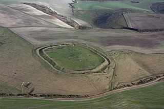
Uffington Castle is an early Iron Age univallate hillfort in Oxfordshire, England. It covers about 32,000 square metres and is surrounded by two earth banks separated by a ditch with an entrance in the western end. A second entrance in the eastern end was apparently blocked up a few centuries after it was built. The original defensive ditch was V-shaped with a small box rampart in front and a larger one behind it. Timber posts stood on the ramparts. Later the ditch was deepened and the extra material dumped on top of the ramparts to increase their size. A parapet wall of sarsen stones lined the top of the innermost rampart. It is very close to the Uffington White Horse on White Horse Hill.

Oxford Castle is a large, partly ruined Norman medieval castle on the western side of central Oxford in Oxfordshire, England. Most of the original moated, wooden motte and bailey castle was replaced in stone in the late 12th or early 13th century and the castle played an important role in the conflict of the Anarchy. In the 14th century the military value of the castle diminished and the site became used primarily for county administration and as a prison. The surviving rectangular St George's Tower is now believed to pre-date the remainder of the castle and be a watch tower associated with the original Saxon west gate of the city.

Wiltshire is a historic county located in the South West England region. Wiltshire is landlocked and is in the east of the region.

Liddington Castle, locally called Liddington Camp, is a late Bronze Age and early Iron Age univallate hill fort in the English county of Wiltshire. At 277 metres (909 ft), it is the highest point in the Borough of Swindon.
Farleigh Hungerford is a village within the civil parish of Norton St Philip in the Mendip district, in Somerset, England, 9 miles southeast of Bath, 3½ miles west of Trowbridge on A366, between Trowbridge and Radstock in the valley of the River Frome.

Pleshey is a historic village and civil parish in the Chelmsford district, in the county of Essex, England, 6 miles (10 km) north-west of Chelmsford. The Normans built a motte and bailey in the late 11th century; the motte is one of the largest of its kind in Great Britain. It was besieged several times during the Barons' Wars and rebellions in the 13th centuries.

Pevensey Castle is a medieval castle and former Roman Saxon Shore fort at Pevensey in the English county of East Sussex. The site is a scheduled monument in the care of English Heritage and is open to visitors. Built around 290 AD and known to the Romans as Anderitum, the fort appears to have been the base for a fleet called the Classis Anderidaensis. The reasons for its construction are unclear; long thought to have been part of a Roman defensive system to guard the British and Gallic coasts against Saxon pirates, it has more recently been suggested that Anderitum and the other Saxon Shore forts were built by a usurper in an ultimately unsuccessful attempt to prevent Rome from reimposing its control over Britain.

Lewes Priory is a part-demolished medieval Cluniac priory in Lewes, East Sussex in the United Kingdom. The ruins have been designated a Grade I listed building.

Pleshey Castle is a man-made motte and bailey castle in Pleshey in Essex, England. It was built in the 11th century and it is one of the best preserved motte and bailey castles in England.

Baltadvaris Castle was a fortified manor house, sometimes incorrectly described as a bastion castle, located about 2 kilometres (1.2 mi) west of Videniškiai in Molėtai District Municipality, Lithuania. Situated on the left bank of the Siesartis River, the castle was surrounded by the river on three sides.

Pennard Castle is a ruined castle, near the modern village of Pennard on the Gower Peninsula, in south Wales. The castle was built in the early 12th century as a timber ringwork following the Norman invasion of Wales. The walls were rebuilt in stone by the Braose family at the turn of the 13th and 14th centuries, including a stone gatehouse. Soon afterwards, however, encroaching sand dunes caused the site to be abandoned and it fell into ruin. Restoration work was carried out during the course of the 20th century and the remains of the castle are now protected under UK law as a Grade II* listed building.

Blewburton Hill is the site of an Iron Age hillfort located in Oxfordshire, in the southeast of England. It was a univallate hillfort. The area is mostly farmland with some small areas of wooded copse to the south and the northeast. The hill fort may have been occupied from the 4th century BC to the 1st century BC, and replaced a small settlement surrounded by a stockade, which is estimated to have been built in the 5th or 6th century BC.

Heimburg Castle, also called the Altenburg or Alteburg, is a ruined castle on an oval hilltop about 330 metres above sea level (NN) which is located just north of the Harz Mountains in central Germany. The ruins of this hilltop castle stand above the village of Heimburg in the borough of Blankenburg in the district of Harz in the state of Saxony-Anhalt. It is checkpoint no. 84 in the Harzer Wandernadel hiking network.

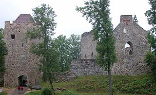
Sigulda Medieval Castle ruins are located on the edge of the Gauja valley in Latvia. The original castle was built in 1207 as a castellum type fortress, later rebuilt into a convent type building. The residence of the Land Marshal of the Livonian Order since 1432.
Kurvingrad or Koprijan (Копријан), is a ruined fortress which sits above the town of Doljevac on the South Morava river, 11 km south of the town of Niš. The ruins are all that remain of the medieval town of Koprijan from the time of Classical antiquity; the fortress is over a thousand years old. Today, fortifications remain, but have not been substantially studied.

The fortifications of Mdina are a series of defensive walls which surround the former capital city of Mdina, Malta. The city was founded as Maleth by the Phoenicians in around the 8th century BC, and it later became part of the Roman Empire under the name Melite. The ancient city was surrounded by walls, but very few remains of these have survived.

Melite or Melita was an ancient city located on the site of present-day Mdina and Rabat, Malta. It started out as a Bronze Age settlement, which developed into a city called Maleth under the Phoenicians, and became the administrative centre of the island. The city fell to the Roman Republic in 218 BC, and it remained part of the Roman and later the Byzantine Empire until 870 AD, when it was captured and destroyed by the Aghlabids. The city was then rebuilt and renamed Medina, giving rise to the present name Mdina. It remained Malta's capital city until 1530.

St James's Church is the main Church of England parish church for the town of Trowbridge, Wiltshire, England. The 15th-century Grade I listed building is the town's most prominent landmark.


