A pictogram, also called a pictogramme, pictograph, or simply picto, and in computer usage an icon, is a graphic symbol that conveys its meaning through its pictorial resemblance to a physical object. Pictographs are often used in writing and graphic systems in which the characters are to a considerable extent pictorial in appearance. A pictogram may also be used in subjects such as leisure, tourism, and geography.
Articles related to Mongolia include:
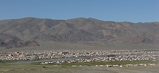
Bayan-Ölgii is the westernmost of the 21 aimags (provinces) of Mongolia. The country's only Muslim and Kazakh-majority aimag, it was established in August 1940. Its capital is Ölgii.

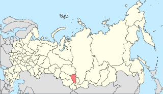
The Bayankhongor Province or Bayanhongor Aimag is one of the 21 aimags (provinces) of Mongolia. It is located in the southwest of the country and, at 116,000 square kilometers, it is one of the largest aimags. The capital of the aimag shares the provincial name, Bayankhongor.

The Mongolian Lunar New Year, commonly known as Tsagaan Sar, is the first day of the year according to the Mongolian lunisolar calendar. The festival of the Lunar New Year is celebrated by the Mongols and some Turkic peoples. The holiday has shamanistic influences.

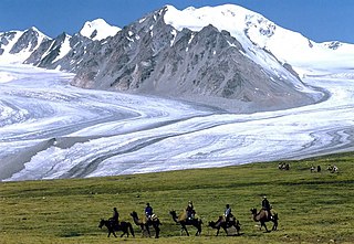
The Tawan Bogd is a mountain massif in Mongolia, near the triple border with China and Russia. Its highest peak, the Khüiten Peak, is the highest point of Mongolia at 4374 meters above sea level.
Khüiten Peak, also known in China as Friendship Peak, is a mountain peak in the Altai Range. The international border between China and Mongolia runs across its summit point, which, at 4,356 metres (14,291 ft), is the highest point in the Altais and the highest in both Mongolia and Altay Prefecture in Western China. The peak is covered in snow year-round.
South Central Siberia is a geographical region north of the point where Russia, China, Kazakhstan and Mongolia come together.
Altai Tavan Bogd National Park is a national park in Bayan-Ölgii Province of western Mongolia. The park includes the Mongolian side of the Tavan Bogd massif, which is divided by the triple border with Russia and China in the Altai Mountains.

Tavan Bogd Group is a Mongolian conglomerate with 14 subsidiaries and four affiliates in trades and services, manufacturing, financial services and mining supplies along with restaurant, tourism and hospitality businesses in Mongolia. Established in 1995, Tavan Bogd Group is one of the largest corporations in Mongolia, officially representing some of the world’s best-known brands such as Toyota, Hitachi mining equipment, Colgate Palmolive, TOTO, L’Occitane, KFC, Pizza Hut, Bridgestone, Heinz, Funai, Xerox and Double A. In addition, Tavan Bogd Group sells luxury cashmere products through the GOBI Corporation, which currently operates about 140 boutique stores in 40 countries.
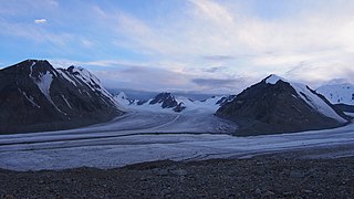
The Potanin Glacier is the longest glacier in Mongolia, it stretches about 14 kilometres and located through in the Altai Tavan Bogd mountain in Altai Mountains. The glacier is named after explorer Grigory Potanin.

Khoton Lake is a freshwater lake in Altai Tavan Bogd National Park in Bayan-Ölgii Province, western Mongolia.

The wildlife of Mongolia consists of flora, fauna and funga found in the harsh habitats dictated by the diverse climatic conditions found throughout the country. In the north, there are salty marshes and fresh-water sources. The centre has desert steppes. In the south, there are semi deserts as well as the hot Gobi desert in the south, the fifth-largest desert in the world.
The climate of Central Asia became dry after the large tectonic collision between the Indian Plate and the Eurasian Plate. This impact threw up the massive chain of mountains known as the Himalayas. The Himalayas, Greater Khingan and Lesser Khingan mountains act like a high wall, blocking the warm and wet climate from penetrating into Central Asia. Many of the mountains of Mongolia were formed during the Late Neogene and Early Quaternary periods. The Mongolian climate was more humid hundreds of thousands of years ago.
The history of Ulaanbaatar, the capital of Mongolia, dates to 1639 when it was first established as a moveable monastery.

The Altai alpine meadow and tundra ecoregion is a terrestrial ecoregion covering the higher elevation of the Altai Mountains at the center of the "X" formed by the borders separating Russia, Kazakhstan, China, and Mongolia. The mountain peaks are the farthest north in Central Asia, separating the plains of Siberia to the north from the hot, dry deserts to the south. Altitudes above 2,400 meters display characteristics of tundra, with patches of alpine meadows and some trees immediately below the treeline. The ecoregion is in the montane grasslands and shrublands biome, and the Palearctic realm, with a humid continental climate. It covers an area of 90,132 square kilometres (34,800 sq mi).

Khurgan Lake (Mongolian: Хурган нуур is a lake located in the district of Tsengel, in the Bayan-Ölgii Province of western Mongolia.
