
Katanga was one of the four large provinces created in the Belgian Congo in 1914. It was one of the eleven provinces of the Democratic Republic of the Congo between 1966 and 2015, when it was split into the Tanganyika, Haut-Lomami, Lualaba, and Haut-Katanga provinces. Between 1971 and 1997, its official name was Shaba Province.

The Congo River, formerly also known as the Zaire River, is the second-longest river in Africa, shorter only than the Nile, as well as the third largest river in the world by discharge volume, following the Amazon and the Ganges rivers. It is also the world's deepest recorded river, with measured depths of around 220 m (720 ft). The Congo-Lualaba-Chambeshi River system has an overall length of 4,700 km (2,900 mi), which makes it the world's ninth-longest river. The Chambeshi is a tributary of the Lualaba River, and Lualaba is the name of the Congo River upstream of Boyoma Falls, extending for 1,800 km (1,100 mi).

Kinshasa is the capital and largest city of the Democratic Republic of the Congo. Once a site of fishing and trading villages along the Congo River, Kinshasa is now one of the world's fastest-growing megacities. With an estimated population of 16 million residents, it's the most densely populated city in the DRC and the most populous city in Africa. Parenthetically, it is Africa's third-largest metropolitan area and the leading economic, political, and cultural center of the DRC. Often described as the "economic giant of Central Africa", it houses numerous industries, including manufacturing, banking, telecommunications, and entertainment. The city also hosts some of DRC's significant institutional buildings, such as the Palais du Peuple, Palais de la Nation, Court of Cassation, Constitutional Court, Cité de l'Union Africaine, Palais de Marbre, Stade des Martyrs, Immeuble du Gouvernement, and multiple federal departments and agencies.

Brazzaville is the capital and largest city of the Republic of the Congo. From an administrative perspective, it is a department and a commune. Constituting the financial and administrative centre of the country, it is located on the north side of the Congo River, opposite Kinshasa, the capital city of the Democratic Republic of the Congo.
Libreville is the capital and largest city of Gabon. Occupying 65 square kilometres (25 sq mi) in the northwestern province of Estuaire, Libreville is a port on the Komo River, near the Gulf of Guinea. As of the 2013 census, its population was 703,904.

The Belgian Congo was a Belgian colony in Central Africa from 1908 until independence in 1960 and became the Republic of the Congo (Léopoldville). The former colony adopted its present name, the Democratic Republic of the Congo (DRC), in 1964.

The Democratic Republic of the Congo (DRC), also known as Congo-Kinshasa, is a country in Central Africa. By land area, the DRC is the second-largest country in Africa and the 11th largest in the world. With a population of around 112 million, the Democratic Republic of the Congo is the most populous officially Francophone country in the world. The national capital and largest city is Kinshasa, which is also the economic center. The country is bordered by the Republic of the Congo, Central African Republic, South Sudan, Uganda, Rwanda, Burundi, Tanzania, Zambia, Angola, the Cabinda exclave of Angola and the South Atlantic Ocean.
This gallery of sovereign state flags shows the national or state flags of sovereign states that appear on the list of sovereign states. For flags of other entities, please see gallery of flags of dependent territories. Each flag is depicted as if the flagpole is positioned on the left of the flag, except for those of the Islamic Emirate of Afghanistan, Iran, Iraq, and Saudi Arabia, which are depicted with the hoist to the right.
Orientale Province is one of the former provinces of the Democratic Republic of the Congo and its predecessors the Congo Free State and the Belgian Congo. It went through a series of boundary changes between 1898 and 2015, when it was divided into smaller units.

Bukavu is a city in eastern Democratic Republic of the Congo (DRC), lying at the extreme south-western edge of Lake Kivu, west of Cyangugu in Rwanda, and separated from it by the outlet of the Ruzizi River. It is the capital of the South Kivu Province and as of 2012 it had an estimated population of 806,940.

Lubumbashi is the second-largest city in the Democratic Republic of the Congo, located in the country's southeasternmost part, along the border with Zambia. The capital and principal city of the Haut-Katanga Province, Lubumbashi is the center of mining in the region, acting as a hub for many of the country's largest mining companies. No definite population figures are available, but the population of the city's urban area is estimated to be around 2,584,000 in 2021.

Kisangani is the capital of Tshopo province in the Democratic Republic of the Congo. It is the fifth most populous urban area in the country, with an estimated population of 1,312,000 in 2021, and the largest of the cities that lie in the tropical woodlands of the Congo.

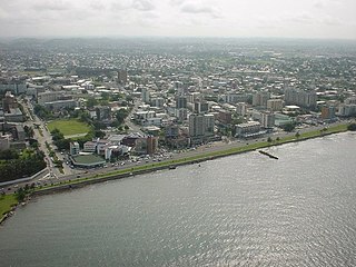
Pointe-Noire is the second largest city in the Republic of the Congo, following the capital of Brazzaville, and an autonomous department and a commune since the 2002 Constitution. Before this date it was the capital of the Kouilou region. It is situated on a headland between Pointe-Noire Bay and the Atlantic Ocean. Pointe-Noire is the main commercial centre of the country and has a population of more than 1 million inhabitants since 2018.

Goma is the capital of North Kivu province in the eastern Democratic Republic of the Congo. It is located on the northern shore of Lake Kivu, next to the Rwandan city of Gisenyi. The lake and the two cities are in the Albertine Rift, the western branch of the East African Rift system. Goma lies only 13–18 km (8.1–11.2 mi) south of the active Nyiragongo Volcano. The recent history of Goma has been dominated by the volcano and the Rwandan genocide of 1994, which in turn fueled the First and Second Congo Wars. The aftermath of these events was still having effects on the city and its surroundings in 2010. The city was captured by rebels of the March 23 Movement during the M23 rebellion in late 2012, but it has since been retaken by government forces.
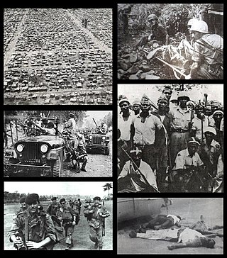
The Congo Crisis was a period of political upheaval and conflict between 1960 and 1965 in the Republic of the Congo. The crisis began almost immediately after the Congo became independent from Belgium and ended, unofficially, with the entire country under the rule of Joseph-Désiré Mobutu. Constituting a series of civil wars, the Congo Crisis was also a proxy conflict in the Cold War, in which the Soviet Union and the United States supported opposing factions. Around 100,000 people are believed to have been killed during the crisis.

UTC+01:00 is an identifier for a time offset from UTC of +01:00. In ISO 8601, the associated time would be written as 2019-02-07T23:28:34+01:00. This time is used in:

Article 2 of the Constitution of the Democratic Republic of the Congo divides the country into the capital city of Kinshasa and 25 named provinces. It also gives the capital the status of a province. Therefore, in many contexts Kinshasa is regarded as the 26th province.

The National Assembly is the lower house and main legislative political body of the Parliament of the Democratic Republic of the Congo. It is one of the two legislative bodies along with the Senate. The National Assembly is composed of deputies who are elected by the citizens of the DRC. The deputies serve as the voice of the people and are responsible for enacting legislation, representing their constituents' interests, and overseeing the executive branch of government. The National Assembly is responsible for deliberating and passing laws that impact the nation and its citizens. It was established by the 2006 constitution, which provided for a bicameral parliament consisting of the National Assembly and the Senate. It is located at the People's Palace in Kinshasa.

The Republic of the Congo, also known as Congo-Brazzaville, the Congo Republic or simply either Congo or the Congo, is a country located on the western coast of Central Africa to the west of the Congo River. It is bordered to the west by Gabon, to its northwest by Cameroon and its northeast by the Central African Republic, to the southeast by the Democratic Republic of the Congo, to its south by the Angolan exclave of Cabinda and to its southwest by the Atlantic Ocean.

The M23 rebellion was an armed conflict in North Kivu, Democratic Republic of the Congo (DRC), that occurred between the March 23 Movement and government forces between 4 April 2012 and 7 November 2013. It ended when a peace agreement was made among eleven African nations, and the M23 troops surrendered in Uganda. The rebellion was part of continued fighting in the region after the formal end of the Second Congo War in 2003. The conflict reignited in late 2021 after rebel "general" Sultani Makenga and 100 rebel fighters attacked the border town of Bunagana but failed. A few months later, with a much larger force, the rebels of the M23 movement renewed their attack and captured Bunagana.
