Related Research Articles

Briscoe County is a county located in the U.S. state of Texas. As of 2010 census, the population was 1,637. Its county seat is Silverton. The county was created in 1876 and later organized in 1892. It is named for Andrew Briscoe, a soldier during the Texas Revolution.

Tulia is a city in, and county seat of, Swisher County, Texas, United States. The population was 4,967 at the 2010 census; in the 2013 census estimate, it had fallen to 4,903. The city is at the junction of U.S. Route 87 and Texas State Highway 86, approximately two miles east of Interstate 27. Tulia is a center for farming and agribusiness activities.
Council is an abandoned townsite in the Nome Census Area in the U.S. state of Alaska. It has a population of zero as of the 2000 and 2010 U.S. Censuses.
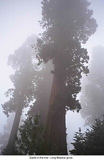
Sequoia National Forest is located in the southern Sierra Nevada mountains of California. The U.S. National Forest is named for the majestic Giant Sequoia trees which populate 38 distinct groves within the boundaries of the forest.

The Tule River, also called Rio de San Pedro or Rio San Pedro, is a 71.4-mile (114.9 km) river in Tulare County in the U.S. state of California. The river originates in the Sierra Nevada east of Porterville and consists of three forks, North, Middle and South. The North Fork and Middle Fork meet above Springville. The South Fork meets the others at Lake Success. Downstream of Success Dam, the river flows west through Porterville. The river used to empty into Tulare Lake, but its waters have been diverted for irrigation. However, the river does reach Tulare Lake during floods. Tulare Lake is the terminal sink of an endorheic basin that historically also received the Kaweah and Kern Rivers as well as southern distributaries of the Kings.
The Beaver River is the historic name for an intermittent river in Oklahoma that drains most of the Oklahoma Panhandle. It is also known as the North Canadian River; both names are in common use. The Beaver River flows from Union County, New Mexico, entering the Oklahoma Panhandle in Cimarron County, then flowing out of state through Sherman County in the Texas Panhandle for about 15 miles (24 km), then back to the Oklahoma panhandle in Texas County, where it is impounded in Optima Lake near Guymon. Downstream of the dam, it continues through the Oklahoma counties of Beaver and Harper before ending in Woodward County.
Solgohachia is an unincorporated community in Conway County, Arkansas, United States, about 10 miles (16 km) north of Morrilton on state highway 9 and Highway 287. The name is from the Choctaw word Sok-ko-huch-cha, meaning "muscadine river".

Letts is an unincorporated community in Sand Creek Township, Decatur County, Indiana.
San Ygnacio Creek is a small stream of water located in Webb County, Texas which runs through Laredo, Texas. The creek is formed 11 miles northwest of Laredo, Texas and runs southwest for 12 mi (19 km) until the creek connects to the Lake Casa Blanca. The terrain surrounding the creek is mostly clay. The vegetation surrounding the creek is mostly made up of mesquite, cacti, and grasses. San Ygnacio Creek does not cross any major highway.
Howard Draw is a valley that heads in the extreme south of Reagan County, Texas at an elevation of 2720 feet at 30°05′09″N101°22′27″W, and runs through Crockett County to its foot on the Pecos River in Val Verde County, elevation 1575 feet.
Johnson Draw, also formerly known as Johnsons Run and Johnson Creek, is a tributary of the Devils River in Val Verde County, Texas. It has its source in Crockett County, Texas at 30°56′03″N101°17′31″W, 17.0 miles north northwest of Ozona, Texas.
The Silver River is a 24.9-mile-long (40.1 km) river in the U.S. state of Michigan. It rises from the outflow of Fisher Lake at 46°39′18″N88°14′06″W and flows in an arc to the northwest and then bending to northeast before emptying into Huron Bay of Lake Superior at 46°48′58″N88°17′45″W.
Tule is a plant of the sedge family.
San Felipe Creek is a stream in Imperial and San Diego Counties of California. It arises in the Volcan Mountains of San Diego County 33°11′57″N116°37′35″W, and runs eastward, gathering the waters of most of the eastern slope of the mountains and desert of the county before it empties into the Salton Sea. It is probably the last remaining perennial natural desert stream in the Colorado Desert region.
Evans Creek, a stream formerly a tributary of California Creek and Devils River it now flows into the western side of Amistad Reservoir at an elevation of 1119 feet. It has its source at 29°45′40″N101°10′06″W, at an elevation 1980 feet, near McNutt Summit.
California Creek, formerly Painted Cave Spring Creek a stream in Val Verde County, Texas, formerly a tributary of Devils River it now flows into the north side of Amistad Reservoir at an elevation of 1119 feet. California Creek has its source at 29°37′29″N101°02′14″W.
Live Oak Creek, a stream with its source in Reagan County, Texas at 31°10′45″N101°42′01″W at an elevation of 2938 feet, that runs southward to its mouth at an elevation of 2001 feet on the Pecos River in Crockett County, Texas.

Village Creek is a blackwater tributary of the Neches River in Texas, United States. It is 63 miles (101 km) long and average streamflow at the mouth is approximately 1,000 cubic feet per second (28 m3/s). Village Creek State Park is located along the creek.
McDonald Creek is a creek in Texas, USA. It is a tributary of Salt Fork Brazos River.
References
- "An Analysis of Texas Waterways" . Retrieved 2006-05-04.
- USGS Hydrologic Unit Map - State of Texas (1974)
Coordinates: 34°40′35″N101°14′06″W / 34.67639°N 101.23500°W

A geographic coordinate system is a coordinate system that enables every location on Earth to be specified by a set of numbers, letters or symbols. The coordinates are often chosen such that one of the numbers represents a vertical position and two or three of the numbers represent a horizontal position; alternatively, a geographic position may be expressed in a combined three-dimensional Cartesian vector. A common choice of coordinates is latitude, longitude and elevation. To specify a location on a plane requires a map projection.
| This article related to a river in Texas is a stub. You can help Wikipedia by expanding it. |