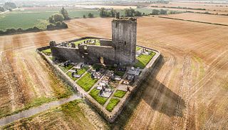
Trim Castle is a castle on the south bank of the River Boyne in Trim, County Meath, Ireland, with an area of 30,000 m2. Over a period of 30 years, it was built by Hugh de Lacy and his son Walter as the caput of the Lordship of Meath. The Irish Government currently own and are in charge of the care of the castle, through the state agency The Office of Public Works (OPW).

Ballyfermot is a suburb of Dublin, Ireland. It is located seven kilometres west of the city centre, south of Phoenix Park. It is bordered by Chapelizod on the north, by Bluebell on the south, by Inchicore on the east, and by Palmerstown and Clondalkin on the west. The River Liffey lies to the north, and the Grand Canal, now a recreational waterway, lies to the south of Ballyfermot. Ballyfermont lies within the postal district Dublin 10. Cherry Orchard, which is also a suburb, is sometimes considered to be within Ballyfermot.

Dunboy Castle is a ruined 15th century castle on the Beara Peninsula in south-west Ireland near the town of Castletownbere. The castle's tower house and bawn were destroyed in the 1602 Siege of Dunboy, though its ruins remain open to the public.
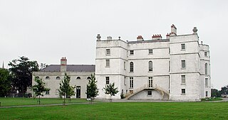
Rathfarnham Castle is a 16th-century fortified house in Rathfarnham, South Dublin, Ireland. Originally a semi-fortified and battlemented structure it underwent extensive alterations in the 18th century. It is in State care, has been restored and is open to the public.

Clondalkin is a suburban town in County Dublin, 10 km (6 mi) west of Dublin city centre, Ireland, under the administrative jurisdiction of South Dublin. It features an 8th-century round tower that acts as a focal point for the area.

Kilcrea Friary is a ruined medieval abbey located near Ovens, County Cork, Ireland. Both the friary and Kilcrea Castle, located in ruin to the west, were built by Observant Franciscans in the mid 15th century under the invitation of Cormac Láidir MacCarthy, Lord of Muskerry, as protection from English troops.
Carrickmines Castle is an archaeological site in Carrickmines, County Dublin, in eastern Ireland. The castle was built in the Middle Ages to protect the English-ruled Pale around Dublin. The mostly subsurface ruins lay in the path of the M50 motorway, completed in 2005. Sections of the medieval walls and some sections of the castle's defensive structures were preserved within or under M50 roundabouts.

Naul, is a village, townland, and civil parish at the northern edge of the traditional County Dublin in Ireland. The Delvin River to the north of the village marks the county boundary with County Meath. Naul civil parish is in the historic barony of Balrothery West.

The River Camac is one of the larger rivers in Dublin and was one of four tributaries of the Liffey critical to the early development of the city.

Rathmichael is a suburb south-east of Dublin, in the local government area of Dún Laoghaire–Rathdown, near the southern border of the traditional County Dublin. It is situated west of Shankill from which it is, roughly, separated by the M50/M11 motorways. It is also a civil parish in the barony of Rathdown.

Bluebell is a small suburb of Dublin, Ireland. Situated approximately 6 kilometres south-west of the city centre, on the Camac, a Liffey tributary, the suburb borders the Grand Canal and Ballyfermot to the west, Walkinstown & Drimnagh to the east, Inchicore to the north, and Clondalkin to the south.

Burnchurch Castle, a National Monument, is a well-preserved 15th century Norman tower house with a round gate tower, situated in the parish of Burnchurch, County Kilkenny, Ireland. Burnchurch Castle and tower, along with the Church of Ireland church, and the lime trees became a National Monument in 1993.

Castle Donovan or Castledonovan or O'Donovan's Castle refer to the remains of an Irish tower house or túrtheach, in a valley near Drimoleague, of medium size which was the so-called "seat" of the Clann Cathail sept of the O'Donovans for a period during the 16th century. The original name of the castle, and when the O'Donovans were actually living in it, was Sowagh before the 17th century. The name of Castle Donovan, after the Manor of the Castle of O'Donovan, is associated with a regrant from James II of England in 1615. Approximately 60 feet in height, it sits on a large rock or outcropping, which forms the ground floor, close to the bank of the River Ilen. It is commonly believed to have been built, or at the very least augmented, by Donal of the Hides, Lord of Clancahill from about 1560 to his death 1584. His son Donal II O'Donovan then repaired or further altered the structure some decades later, but was not living in it by then. It is believed that his father had already relocated the family in the first decade of that century to the more profitable Rahine Manor on the seacoast to protect their maritime interests.
Newcastle is a feudal title of nobility and one of the baronies of Ireland. It was constituted as part of the old county of Dublin. Today, it lies in the modern county of South Dublin. At the heart of the barony is the civil parish of the same name - Newcastle - which is one of eleven civil parishes in the barony. The ruins of the eponymous castle, also known as Newcastle-Lyons, are located in the townland of Newcastle South. The town with the biggest population in the barony is Lucan.

Kilcrea Castle is a ruined 15th-century towerhouse and bawn located near the Kilcrea Friary, west of Cork City, Ireland. The tower house and friary were both built by Cormac Laidir MacCarthy, 9th Lord of Muskerry.
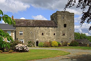
Athclare Castle is a Tudor tower house in the Dunleer area of County Louth in Ireland. Built in the 1550s, Athclare was built for the Barnewell family, and is typical of defensive architectural structures built in the Pale during the Tudor period in Ireland. Athclare has been extended and adapted in the centuries since its construction and is classified as a site of National social historical importance by the Irish National Inventory of Architectural Heritage.
Baldongan Church, also called Baldungan Castle, is an ancient ruined church and National Monument near Skerries, County Dublin, Ireland.
Clondalkin Round Tower is an Irish round tower or cloigtheach founded by Saint Mochua, also known as Saint Cronan, and located in Clondalkin, South Dublin, Ireland. It is now a National Monument of Ireland. It's also become a museum that houses a cafe.