Benburb ) is a village and townland in County Tyrone, Northern Ireland. It lies 7.5 miles from Armagh and 8 miles from Dungannon. The River Blackwater runs alongside the village as does the Ulster Canal.

Creggan is a townland in County Tyrone, Northern Ireland. It is situated in the historic barony of Omagh East and the civil parish of Termonmaguirk and covers an area of 4022 acres.

Beragh is a village and townland in County Tyrone, Northern Ireland. It is about 8 miles Southeast of Omagh and is in the Fermanagh and Omagh District Council area. The 2001 Census recorded a population of 520.

Artigarvan is a village and townland in County Tyrone, Northern Ireland. It is 3 miles from Strabane and 4 miles from Dunnamanagh, within the Strabane District Council area. It is called Airtigarvan in Ulster-Scots.

Ballymagorry or Ballymagory is a small village and townland in County Tyrone, Northern Ireland. It is west of Artigarvan and 5 kilometres (3.1 mi) north of Strabane. In the 2001 Census it had a population of 565. It lies within the Strabane District Council area and lies on the River Glenmornan.

Altamuskin or Altamooskan is a small village and townland in County Tyrone, Northern Ireland. It is situated in the historic barony of Clogher and the civil parish of Errigal Keerogue and covers an area of 1165 acres. In the 2014 Census Altamuskin had a population of 127 people. It lies within the Fermanagh and Omagh District Council area and is home to St Bridget's Altamuskin. The population of the townland declined during the 19th century:

Dooish (Irish: Dubhais is a village and townland near Drumquin in County Tyrone, Northern Ireland. The townland is situated in the historic barony of Omagh West and the civil parish of Longfield West and covers an area of 845 acres. In the 2001 Census it had a population of 93 people. It lies within the Omagh District Council area.

Brackaville or Bracaville is a village and townland near Coalisland in County Tyrone, Northern Ireland. It is situated in the historic barony of Dungannon Middle and the civil parish of Donaghenry and covers an area of 235 acres on the western side of Lough Neagh.
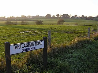
Drumkee is a townland in the southeast of County Tyrone, Northern Ireland. It is directly south of the area presently known as Coalisland and east, and slightly north, of Dungannon. It is situated in the historic barony of Dungannon Middle and the civil parish of Killyman and covers an area of 285 acres. The barony's tax records dated 1666 list two families living in Drumkee.

Evish is a small rural community area and townland in County Tyrone, Northern Ireland, 3 miles from Strabane and 7 miles from Plumbridge. It is situated in the barony of Strabane Lower and the civil parish of Camus and covers an area of 870 acres.

Carnteel ) is a hamlet, townland and civil parish, about 2 miles northeast of Aughnacloy in County Tyrone, Northern Ireland. It is situated in the historic barony of Dungannon Lower.

Derrytresk is a townland outside Coalisland, County Tyrone, Northern Ireland and is close to the shores of Lough Neagh. It is situated in the historic barony of Dungannon Middle and the civil parish of Clonoe and covers an area of 1020 acres. Derrytresk consists of sub-townlands: Derryvarne, Derrykiltena and Derrynahaskila.
Ballymully Glebe is a townland in County Tyrone, Northern Ireland. It is situated in the historic barony of Dungannon Upper and the civil parish of Desertcreat and covers an area of 144 acres.
Altishane or Altishahane is a small settlement and townland in County Tyrone, Northern Ireland. It lies near Strabane, between Plumbridge and Donemana. It is situated in the historic barony of Strabane Lower and the civil parish of Donaghedy and covers an area of 744 acres. There is one primary school, Altishane Primary School.

Carnan is a townland in County Tyrone, Northern Ireland. It is situated in the historic barony of Dungannon Upper and the civil parish of Arboe and covers an area of 465 acres.
Branny is a townland in County Tyrone, Northern Ireland. It is situated in the historic barony of Dungannon Lower and the civil parish of Carnteel and covers an area of 228 acres.

Doocrock is a townland in County Tyrone, Northern Ireland. It is situated in the historic barony of Omagh East and the civil parish of Dromore and covers an area of 426 acres.

Kilcroagh is a townland in County Tyrone, Northern Ireland, near Castlederg. It is situated in the historic barony of Omagh West and the civil parish of Urney and covers an area of 351 acres.

Carrigans is a townland in County Tyrone, Northern Ireland. It is situated in the historic barony of Strabane Upper and the civil parish of Cappagh and covers an area of 859 acres.
Derryloughan is a townland in County Tyrone, Northern Ireland. It lies on the southwest corner of Lough Neagh, 4 miles from Coalisland. It is situated in the historic barony of Dungannon Middle and the civil parish of Clonoe and covers an area of 1751 acres.
