Cookstown is a small town in County Tyrone, Northern Ireland. It is the fourth largest town in the county and had a population of 11,599 in the 2011 census. It, along with Magherafelt and Dungannon, is one of the main towns in the Mid-Ulster council area. It was founded around 1620 when the townlands in the area were leased by an English ecclesiastical lawyer, Dr. Alan Cooke, from the Archbishop of Armagh, who had been granted the lands after the Flight of the Earls during the Plantation of Ulster. It was one of the main centres of the linen industry west of the River Bann, and until 1956, the processes of flax spinning, weaving, bleaching and beetling were carried out in the town.

Sir Phelim Roe O'Neill of Kinard, was an Irish nobleman who led the Irish Rebellion of 1641 in Ulster, which began on 23 October 1641. He joined the Irish Catholic Confederation during the Wars of the Three Kingdoms, in which he fought under his kinsman and second cousin, Owen Roe O'Neill in the Confederate Ulster Army. In 1653 Phelim O’Neill had sought refuge on an old crannog in Roughan Lough while staying at Roughan Castle but was captured after his hideout was betrayed.

Dromore is a village, townland and civil parish in County Tyrone, Northern Ireland. It is nine miles (15 km) south west of Omagh on the A32 and sixteen miles (26 km) from Enniskillen. The population of Dromore was 1,198 at the 2011 Census.

Benburb ) is a village and townland in County Tyrone, Northern Ireland. It lies 7.5 miles from Armagh and 8 miles from Dungannon. The River Blackwater runs alongside the village as does the Ulster Canal.

Castlecaulfield is a village in County Tyrone, Northern Ireland. It lies about 2 miles west of Dungannon and is part of the Mid Ulster District Council area. The village is mostly within the townland of Drumreany, although part of it extends into Lisnamonaghan. It is situated in the historic Barony of Dungannon Middle and the civil parish of Donaghmore. It has been called "Caufle" by local people for upwards of two hundred years as evidenced by a sketch of the Castle c1830 in which the artist refers to 'Castle Coffell'.

Stewart Castle is situated in Newtownstewart, County Tyrone, Northern Ireland. It was built in 1619 by Sir Robert Newcomen in an English manor house style. It was damaged during the Irish Rebellion of 1641 by Sir Phelim O' Neill and in 1689 on King James' return from the Siege of Derry. King James ordered the Stewart Castle, and the town, to be burnt down. In the main street a piece of the castle wall still stands.
Augher is a small village in south County Tyrone, Northern Ireland. It lies just 6 miles to the County Monaghan Border and is 16 miles south of Dungannon. It is situated in the historic barony of Clogher and the civil parish of Clogher. The 2001 Census recorded a population of 399.The town gives its name to the local Gaelic Football Club. Augher was also a victim to several bombings throughout the 1980s and 1990s with 7 bombings in the town, from both the IRA and the UVF. The most recent of these bombings was by the IRA in 1992 against Clogher valley creamery, a domintaly protestant creamery. The last native Irish speaking residents of Augher, John and Bridie Treanor died in 1895. However, it is noted Augher village has been both majority Irish and Catholic since 2001.
Caledon is a small village and townland in County Tyrone, Northern Ireland. It is in the Clogher Valley on the banks of the River Blackwater, 7 miles from Armagh. It lies in the southeast of Tyrone and near the borders of County Armagh and County Monaghan. It is situated in the historic barony of Dungannon Lower and the civil parish of Aghaloo. In the 2001 Census it had a population of 387 people. It is a designated conservation area. It was historically known as Kinnaird (Irish: Cionn Aird, meaning "head/top of the height or hill".

Shanmaghery or Shanmaghry is a small hamlet and townland in County Tyrone, Northern Ireland, situated three miles from Pomeroy and three miles from Galbally. It is situated in the barony of Dungannon Middle and the civil parish of Pomeroy and covers an area of 426 acres. In 1841 the population of the townland was 193 people and in 1851 it was 161 people. "Paul's Planting" was a notable landmark on top of the hill.

Evish is a small rural community area and townland in County Tyrone, Northern Ireland, 3 miles from Strabane and 7 miles from Plumbridge. It is situated in the barony of Strabane Lower and the civil parish of Camus and covers an area of 870 acres.

Carnteel ) is a hamlet, townland and civil parish, about 2 miles northeast of Aughnacloy in County Tyrone, Northern Ireland. It is situated in the historic barony of Dungannon Lower.

Calmore is a townland lying within the civil parish of Kilcronaghan, County Londonderry, Northern Ireland. It lies in the north-west of the parish, and is bounded by the townlands of; Granny, Moneyshanere, Moyesset, and Tobermore. It was apportioned to the Drapers company as well as Crown freeholds.

Agharaskilly is a townland in the civil parish of Tomregan, County Cavan, Ireland. It lies within the former barony of Loughtee Lower.

Favor Royal Demesne, also spelled Favour Royal, is a townland in County Tyrone, Northern Ireland. It is situated in the barony of Clogher and the civil parish of Errigal-Trough, adjacent to the Irish border. The townland covers an area of 670 acres (270 ha).

Trickvallen is a townland in County Tyrone, Northern Ireland. It is situated in the barony of Dungannon Upper and the civil parish of Arboe and covers an area of 279 acres.

Tullagherin is a townland in County Tyrone, Northern Ireland. It is situated in the barony of Strabane Upper and the civil parish of Bodoney Upper and covers an area of 937 acres.
Tullylinton is a townland in County Tyrone, Northern Ireland. It is situated in the barony of Clogher and the civil parish of Errigal Keerogue and covers an area of 176 acres.

Tullylig is a townland in County Tyrone, Northern Ireland. It is situated in the barony of Dungannon Middle and the civil parish of Donaghenry and covers an area of 131 acres.
Drumlarah is a townland in the civil parish of Kildallan, barony of Tullyhunco, County Cavan, Ireland.
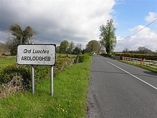
Ardlougher is a townland in the civil parish of Kildallan, barony of Tullyhunco, County Cavan, Ireland.
