Baujinath is a business center in Sanphebagar Municipality in Achham District in the Seti Zone of western Nepal. It was annexed to form the new municipality since 18 May 2014. According to the 1991 Nepal census, the village had a population of 1160 living in 237 houses. At the time of the 2001 Nepal census, the population was 1345, of which 70% was literate.
Bhagyeshwar is a business center in Sanphebagar Municipality in Achham District in the Seti Zone of western Nepal. It was annexed to form the new municipality since 18 May 2014. According to the 1991 Nepal census, the village had a population of 1158 living in 257 houses. At the time of the 2001 Nepal census, the population was 1321, of which 62% was literate.
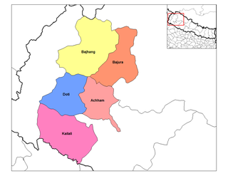
Bhairavsthan is a village in Achham District in the Seti Zone of western Nepal. According to the 1991 Nepal census, the village had a population of 2869 living in 504 houses. At the time of the 2001 Nepal census, the population was 3486, of which 39% was literate.

Chalsa is a former village development committee in Achham District in the Seti Zone of western Nepal. At the time of the 1991 Nepal census, the village had a population of 1721 living in 289 houses. At the time of the 2001 Nepal census, the population was 2142, of which 26% was literate. Chalsa now is part of Kamalbazar Municipality which was established in 2014.
Chapamandau is a village in Achham District in the Seti Zone of western Nepal. At the time of the 1991 Nepal census, the village had a population of 1073 living in 211 houses. At the time of the 2001 Nepal census, the population was 1188, of which 51% was literate.
Dumi is a village in Achham District in the Seti Zone of western Nepal. At the time of the 1991 Nepal census, the village had a population of 1517 living in 332 houses. At the time of the 2001 Nepal census, the population was 1877, of which 35% was literate.
Nandegata is a village in Achham District in the Seti Zone of western Nepal. At the time of the 1991 Nepal census, the village had a population of 2881 living in 542 houses. At the time of the 2001 Nepal census, the population was 3356, of which 33% was literate.
Walant is a village in Achham District in the Seti Zone of western Nepal. At the time of the 2001 Nepal census, the population was 3624, of which 20% was literate.
Sakot is a small town in Achham District in the Seti Zone of western Nepal. At the time of the 1991 Nepal census, the town had a population of 5195 living in 1113 houses. At the time of the 2001 Nepal census, the population was 5843, of which 24% was literate.
Khunga is a Village Development Committee in Baglung District in the Dhaulagiri Zone of central Nepal. At the time of the 1991 Nepal census it had a population of 2,926 and had 583 houses in the town.
Kalleri is a village development committee in Dhading District in the Bagmati Zone of central Nepal. At the time of the 1991 Nepal census it had a population of 7848 and had 1433 houses in it.
Tolidewal is a village in Bajura District in the Seti Zone of north-western Nepal. At the time of the 1991 Nepal census it had a population of 2,991 and had 599 houses in the village.
Deurali is a Village Development Committee in Gorkha District in the Gandaki Zone of northern-central Nepal. At the time of the 1991 Nepal census it had a population of 4,800 and had 984 houses in the town.
Saya is a village and municipality in Humla District in the Karnali Zone of north-western Nepal. At the time of the 1991 Nepal census it had a population of 1422 persons living in 268 individual households.
Manpur is a town and Village Development Committee in Dang Deokhuri District in the Rapti Zone of south-western Nepal. At the time of the 1991 Nepal census it had a population of 9,960 persons residing in 1449 individual households.
Samundratar is a village development committee in Nuwakot District in the Bagmati Zone of central Nepal. At the time of the 1991 Nepal census it had a population of 1859 people living in 364 individual households.
Bhusapheda is a village development committee in Dolakha District in the Janakpur Zone of north-eastern Nepal. At the time of the 1991 Nepal census it had a population of 2024 people living in 450 individual households.
Rumale is a village development committee in Mugu District in the Karnali Zone of north-western Nepal. At the time of the 1991 Nepal census it had a population of 1154 people living in 220 individual households.
Mashtanamdali is a former Village development committee in Achham District in the Seti Zone of western Nepal. At the time of the 1991 Nepal census, the village had a population of 1995 living in 350 houses. At the time of the 2001 Nepal census, the population was 2004, of which 31% was literate. Mashtanamdali now is part of Kamalbazar Municipality which was established in 2014.