
Farmington is a town in Hartford County in the Farmington Valley area of central Connecticut in the United States. The town is part of the Capitol Planning Region. The population was 26,712 at the 2020 census. It sits 10 miles west of Hartford at the hub of major I-84 interchanges, 20 miles south of Bradley International Airport and two hours by car from New York City and Boston. It has been home to the world headquarters of several large corporations including Otis Elevator Company, United Technologies, and Carvel. The northwestern section of Farmington is a suburban neighborhood called Unionville.

Hartland is a town in Hartford County, Connecticut, United States. The population was 1,901 at the 2020 census. The rural town is part of the Northwest Hills Planning Region and forms the northwest border of Hartford County. Currently, the town consists of two unincorporated areas, East and West Hartland, entirely separated by the northern portion of the Barkhamsted Reservoir. A third area, Hartland Hollow, was flooded when the reservoir was completed in 1940.
Simsbury is a town in Hartford County, Connecticut, United States, incorporated as Connecticut's 21st town in May 1670. The town is part of the Capitol Planning Region. The population was 24,517 in the 2020 census.

Southington is a town in Hartford County, Connecticut, United States. The town is part of the Capitol Planning Region. As of the 2020 United States Census, it had a population of 43,501. Southington contains the villages of Marion, Milldale, and Plantsville.

The Farmington River is a river, 46.7 miles (75.2 km) in length along its main stem, located in northwest Connecticut with major tributaries extending into southwest Massachusetts. The longest route of the river, from the origin of its West Branch, is 80.4 miles (129.4 km) long, making it the Connecticut River's longest tributary by 2.3 miles (3.7 km) over the major river directly to its north, the Westfield River. The Farmington River's watershed covers 609 square miles (1,580 km2). Historically, the river played an important role in small-scale manufacturing in towns along its course, but it is now mainly used for recreation and drinking water.

Tunxis Community College is a public community college in Farmington, Connecticut. Opened in 1969, it is named after the Tunxis Native American Tribe and is part of the Connecticut Community Colleges system.
The Tunxis were a group of Quiripi speaking Connecticut Native Americans that is known to history mainly through their interactions with English settlers in New England. Broadly speaking, their location makes them one of the Eastern Algonquian-speaking peoples of Northeastern North America, whose languages shared a common root. More locally they were one of a number of Native communities in the lower Connecticut River Valley who shared common cultural traits.

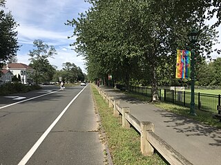
The Farmington Canal Heritage Trail is an 81.2-mile (130.7 km) multi-use rail trail located in Connecticut and Massachusetts.
USS Tunxis is a name used more than once by the United States Navy:

The Blue-Blazed Hiking Trail (BBHT) system, managed by the Connecticut Forest & Park Association (CFPA), and the related trail systems documented in the two-volume 19th Edition of the "Connecticut Walk Book" comprise over 800 miles of hiking trails in Connecticut.

Granville State Forest is a Massachusetts state park located in the towns of Granville and Tolland in the southern Berkshire Hills along the state's southern border with Connecticut. The park is managed by the Department of Conservation and Recreation (DCR). It is adjacent to Connecticut's Tunxis State Forest.

The Tunxis Trail is a 79-mile (127 km) Blue-Blazed hiking trail "system" that traverses the western ridge of the central Connecticut Valley. The mainline trail is not completely contiguous, notably there are two gaps of several miles.
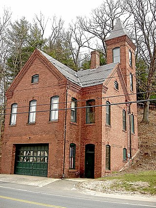
The Tunxis Hose Firehouse is an historic firehouse at Lovely Street and Farmington Avenue in the center of Unionville, Connecticut. BUilt in 1893, it is a well-preserved example of a late 19th-century rural firehouse with Queen Anne Victorian features. The building was listed on the National Register of Historic Places on July 28, 1983. It presently houses a muster vehicle for Tunxis Hose Company No. 1, a local volunteer fire company.
Massaco was a native settlement near the present-day towns of Simsbury and Canton along the banks of the Farmington River. The small, local Algonquian-speaking Indians who lived there in the 17th and early 18th centuries belonged to the Tunxis, a Wappinger people.

Satan's Kingdom State Recreation Area is a public recreation area occupying one-acre of land beside the Farmington River in the town of New Hartford, Connecticut. The site is located on the north side of the Route 44 bridge over the Farmington River. It is used as a put-in for canoeing, kayaking, and tubing excursions on the river.

Nepaug State Forest is a Connecticut state forest located primarily in the town of New Hartford.

Tunxis State Forest is a state forest located in the towns of Hartland, Barkhamsted, and Granby in Connecticut, United States. The forest surrounds Barkhamsted Reservoir and borders the Granville State Forest in Massachusetts. The forest is used for hiking, mountain biking, cross-country skiing, fishing, hunting, and letterboxing. Several trails cross the forest, including the northern end of the blue-blazed Tunxis Trail.

The Tomasso Group is a family-run conglomerate focused on the construction and real estate industries based in New Britain, Connecticut.
Johnnycake Mountain is the highest peak in Burlington, Connecticut at 1,161 ft and the 7th highest peak in Hartford County at the foothills of the Berkshires. The summit reflects the historical usage as a significant portion of the area was cleared of trees for farming; however, it is now developed with single-family homes. From the summit, one can see the Farmington River Valley and Heublein Tower to the east. The blue-blazed and white dot Tunxis Trail traverses the mountain, leading to a network of other trails in nearby Sessions Woods Wildlife Management Area and Nassahegon State Forest.