
Chumbivilcas(3D-map) is a province in the Andes in South Peru. The Inca called it "Chumpiwillka". The seat of the province is Santo Tomás. Officially Chumbivilcas was founded on June 21, 1825.

Calca Province is one of thirteen provinces in the Cusco Region in the southern highlands of Peru. Its seat is Calca.

Canas Province is one of thirteen provinces in the Cusco Region in the southern highlands of Peru.

Canchis Province is one of thirteen provinces in the Cusco Region in the southern highlands of Peru.

Cusco Province is the smallest of thirteen provinces in the Cusco Region in the southern highlands of Peru.

Paucartambo Province is one of thirteen provinces in the Cusco Region in the southern highlands of Peru.

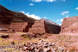
Quispicanchi Province is one of thirteen provinces in the Cusco Region in the southern highlands of Peru.

The Ocongate District is one of the twelve districts in the Quispicanchi Province in Peru. Created on January 2, 1857, its capital is the town of Ocongate.
The Cusipata District is one of the twelve districts in the Quispicanchi Province in Peru. Created by Law No. 9164 on September 5, 1940, its capital is the town of Cusipata.
The Lucre District is one of the twelve districts in the Quispicanchi Province in Peru. Created by Law No. 9295 on January 17, 1941, its capital is the town of Lucre.
Pitumarca District is one of eight districts of the province Canchis in Peru.
Jatun Pucacocha is a lake in Peru located in the Cusco Region, Quispicanchi Province, Ocongate District. It is about 0.9 km long and 0.58 km at its widest point. Jatun Pucacocha lies southwest of the mountain Ausangate of the Vilcanota mountain range, between the lakes Uchuy Pucacocha in the northwest and Pucacocha in the southeast.

Jatunñaño Punta or Jatunñano Punta is a mountain in the Vilcanota mountain range in the Andes of Peru, about 5,812 metres (19,068 ft) high. It is situated in the Cusco Region, Canchis Province, Pitumarca District, and in the Quispicanchi Province, Marcapata District. Jatunñaño Punta lies north of the lake Sibinacocha.
Luychu Urqu is a mountain in the Cusco Region in Peru, about 4,430 metres (14,534 ft) high. It is situated in the Paucartambo Province, Colquepata District, and in the Quispicanchi Province, Ccatca District. Luychu Urqu lies south of the mountain Hatun Urqu (Jatun Orjo), east of the mountain Raqch'i Raqch'iyuq (Rajchi Rajchiyoc) and north of the mountains Q'illu Unuyuq (Quello Unuyoc) and Sipulturayuq (Sepulturayoc).
Jatunrritioc is a mountain in the Vilcanota mountain range in the Andes of Peru, about 5,000 metres (16,404 ft) high. It lies in the Cusco Region, Canchis Province, Pitumarca District, and in the Quispicanchi Province, Cusipata District. Jatunrritioc is situated south of the mountain Huasacocha, north-west of the mountain Yaritani and north-east of the mountain Chachacomayoc.
Ch'aqu is a mountain in the Andes of Peru, about 5,000 metres (16,404 ft) high. It is located in the Cusco Region, Quispicanchi Province, Cusipata District. It lies northeast of Hatun Ch'aqu and Yanaqaqa and northwest of Yuraq Q'asa. Ch'aqu is situated on the left bank of the river Pukamayu which flows to the west as a right affluent of the Willkanuta River. The confluence is near Cusipata.
Yuraq Q'asa is a mountain in the Andes of Peru, about 4,800 metres (15,748 ft) high. It lies in the Cusco Region, Canchis Province, Pitumarca District, and in the Quispicanchi Province, Cusipata District. Yuraq Q'asa is situated south of the mountain Ch'aqu, west of the mountain Chachakumayuq and north-east of the mountain Tiklla Q'asa.
Hatun Ch'aqu is a mountain in the Andes of Peru, about 5,000 metres (16,404 ft) high. It is located in the Cusco Region, Canchis Province, Pitumarca District, and in the Quispicanchi Province, Cusipata District. It lies south-west of the mountain Ch'aqu, west of the mountain Yanaqaqa, north-west of the mountain Tiklla Q'asa and north of the mountain Tuqtu. Its ridge stretches to the north-west.
Tiklla Q'asa is a mountain in the Andes of Peru, about 4,800 metres (15,748 ft) high. It is situated in the Cusco Region, Canchis Province, Pitumarca District, and in the Quispicanchi Province, Cusipata District. Tiklla Q'asa lies southwest of Ch'aqu and Yuraq Q'asa and southeast of Tuqtu and Hatun Ch'aqu.
Jatun Punta is a mountain in the Vilcanota mountain range in the Andes of Peru, about 5,200 metres (17,060 ft) high. It is situated in the Cusco Region, Quispicanchi Province, Ocongate District. Jatun Punta lies southwest of Callangate and west Puca Punta.


