Donaldson is a census-designated place (CDP) in Frailey Township, Schuylkill County, Pennsylvania, United States. The population was 325 at the 2000 census.
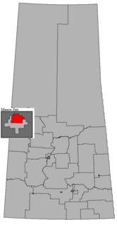
Moose Jaw North is a provincial electoral district for the Legislative Assembly of Saskatchewan, Canada. One of two provincial constituencies for the city of Moose Jaw, the riding's southern boundary follows Caribou Street from the Trans-Canada bypass in the east to the city limits in the west.

For the clothing style among some indigenous peoples in Panama, Puerto Rico and Costa Rica see Ngäbe people#Dress
Carcastillo is a town and municipality located in the province and autonomous community of Navarre, in the north of Spain. It is the site of the Cistercian monastery of Santa María de la Oliva.

KONP is a radio station based in Port Angeles, Washington. It signed on the air at 6:30 a.m. local time February 3, 1945.

Manes is an unincorporated community in Wright County, Missouri, United States. It is located on Route 95 about 12 miles northeast of Hartville.

Bundesautobahn 261 is an autobahn located between Hamburg and Buchholz in der Nordheide. It connects the A 7 with the A 1.
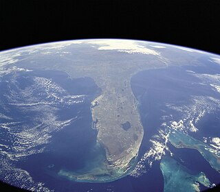
North Carolina's 3rd congressional district is located on the Atlantic coast of North Carolina. It covers the Outer Banks and the counties adjacent to the Pamlico Sound.
Kumaka is a village in the East Berbice–Corentyne region of Guyana. It stands on the right bank of the upper Essequibo River, about 35 km above Apoteri and the confluence of the Rupununi River with the Essequibo, at an elevation of 105 metres. Kumaka has a population of about 2190 as of 2007.

Indian Wells is an unincorporated community in Navajo County, Arizona, United States. Indian Wells Elementary School is located in the town, it serves 600 students. It is also the name of the local Navajo chapter of the Navajo Nation Council. Indian Wells is served by a post office with the ZIP code of 86031. The ZIP Code Tabulation Area for ZIP Code 86031 had a population of 1,856 at the 2010 census, with 255 in Indian Wells itself.
Large Island is an islet between Grenada and Carriacou (Grenadines). It is part of Carriacou and Petite Martinique, a dependency of Grenada.
WNKJ is a Christian radio station licensed to Hopkinsville, Kentucky, broadcasting on 89.3 MHz FM. The station serves the areas of Hopkinsville, Kentucky and Clarksville, Tennessee, and is owned by Pennyrile Christian Community, Inc.

Collier Hills is a residential neighborhood in Atlanta, Georgia. The area gets its name from the family whose homestead was broadly located in the southwest corner of the intersection of Peachtree St. and Collier Rd. Andrew Jackson Collier, a member of this family and early pioneer of the area, operated an antebellum grist mill off Tanyard Creek, near Collier Rd.

Curlew is an unincorporated community in Imperial County, California. It is located on a former branch of the Southern Pacific Railroad 8.5 miles (14 km) north of Holtville, at an elevation of 89 feet below sea level.
Perrys Corner is an unincorporated community in Imperial County, California. It is located 3.5 miles (5.6 km) north of Holtville, at an elevation of 49 feet below sea level.

Taourirt is a province in the Oriental Region of Morocco. Its population in 2004 is 206,762

Grande Ecaille is an unincorporated community located in the parish of Plaquemines, Louisiana, United States.
St. Vincent College (CDP) is a census-designated place located in Unity Township, Westmoreland County in the state of Pennsylvania. The community is centered on Saint Vincent College located to the south of Latrobe near U.S. Route 30. As of the 2010 census the population was 1,357 residents.
Riverside is an unincorporated community in Jefferson County, in the U.S. state of Missouri.
McCune is an unincorporated community in Pike County, in the U.S. state of Missouri.