Look up tuya in Wiktionary, the free dictionary.
A tuya is a distinctive, flat-topped, steep-sided volcano.
Tuya may refer to:
A tuya is a distinctive, flat-topped, steep-sided volcano.
Tuya may refer to:

In geology and physical geography, a plateau, also called a high plain or a tableland, is an area of a highland consisting of flat terrain that is raised sharply above the surrounding area on at least one side. Often one or more sides have deep hills or escarpments. Plateaus can be formed by a number of processes, including upwelling of volcanic magma, extrusion of lava, and erosion by water and glaciers. Plateaus are classified according to their surrounding environment as intermontane, piedmont, or continental. A few plateaus may have a small flat top while others have wider ones.

A subglacial volcano, also known as a glaciovolcano, is a volcanic form produced by subglacial eruptions or eruptions beneath the surface of a glacier or ice sheet which is then melted into a lake by the rising lava. Today they are most common in Iceland and Antarctica; older formations of this type are found also in British Columbia and Yukon Territory, Canada.
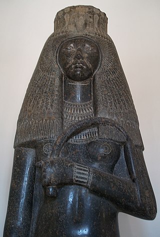
Tuya was the wife of Pharaoh Seti I of the Nineteenth Dynasty of Egypt and mother of Tia, Ramesses II, and perhaps Henutmire.
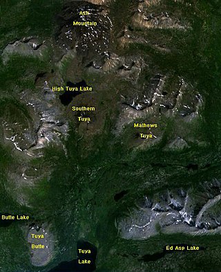
Tuya Mountains Provincial Park is a provincial park in British Columbia, Canada, protecting the Tuya Range, a volcanic region at the head of the Tuya River. The park is located on the north side of Tuya Lake. The park is named for nearby Tuyas, steep-sided, flat-topped types of volcano.

A tuya is a flat-topped, steep-sided volcano formed when lava erupts through a thick glacier or ice sheet. They are rare worldwide, being confined to regions which were covered by glaciers and had active volcanism during the same period.
The Tuya volcanic field is a volcanic field of tuyas located in far northern British Columbia, Canada, near the border with the Yukon Territory and focused on the area of the Tuya Range, a subrange of the Stikine Ranges of the Cassiar Mountains, though some vents are in the Kawdy Plateau, the northernmost part of the Stikine Plateau. Several small shield volcanoes, and postglacial lapilli cones and lava flows have been reported in this area. The only nonglacial volcanoes in the field are Gabrielse Cone and the West Tuya lava field.

The Table, sometimes called Table Mountain, is a 2,021-metre (6,631 ft) high flow-dominated andesite tuya located 4 kilometres (2 mi) south of Garibaldi Lake, 15 kilometres (9 mi) northeast of Cheekye and 5 kilometres (3 mi) north of Mount Garibaldi, British Columbia, Canada. It rises over 530 metres (1,740 ft) above the surface of Garibaldi Lake, which lies less than 1 kilometre (1 mi) to the north.
Tuya Butte is a tuya in the Tuya Range of north-central British Columbia, Canada. It is a bit less isolated from other ranges than neighbouring Mount Josephine. Some of the other volcanoes in the area include South Tuya, Ash Mountain, and Mathews Tuya.
Ash Mountain is the highest summit in the Tuya Range of the Stikine Ranges in northcentral British Columbia, Canada, located immediately north of High Tuya Lake at the north end of Tuya Mountains Provincial Park. It is one of the six tuyas clustered close to Tuya Lake. The base of the volcano comprises pillow lava and hyaloclastite indicating that the volcano formed beneath ice or under a large lake. The volcano comprises loose debris as well as dikes of basaltic rock that intruded into the volcanic pile. Other tuyas in the area include Tuya Butte, South Tuya and Mathews Tuya, although most of the group of tuyas are unnamed.
Mathews Tuya is a tuya in northcentral British Columbia. It is one of the six tuyas close to Tuya Lake. It has been partly glaciated and Ar-Ar geochronology shows that is it about 730,000 years old. It mainly comprises palagonitized tephra but also has a few dykes and jointed lava flows on its flanks. The top still has flat-lying lava flows erupted after the tephra pile grew above the surface of the enclosing lake. The other volcanoes in the area include Tuya Butte, South Tuya and Ash Mountain. The volcanoes in the region form part of the Northern Cordilleran Volcanic Province.
The Tuya Range is a mountain range in the Stikine Ranges of the Cassiar Mountains in the far north of the Canadian province of British Columbia, near its border with the Yukon Territory and to the southwest of Watson Lake, Yukon, which is the nearest major settlement.

Level Mountain is a large volcanic complex in the Northern Interior of British Columbia, Canada. It is located 50 kilometres north-northwest of Telegraph Creek and 60 kilometres west of Dease Lake on the Nahlin Plateau. With a maximum elevation of 2,164 metres, it is the second-highest of four large complexes in an extensive north–south trending volcanic region. Much of the mountain is gently-sloping; when measured from its base, Level Mountain is about 1,100 metres tall, slightly taller than its neighbour to the northwest, Heart Peaks. The lower, broader half of Level Mountain consists of a shield-like structure while its upper half has a more steep, jagged profile. Its broad summit is dominated by the Level Mountain Range, a small mountain range with prominent peaks cut by deep valleys. These valleys serve as a radial drainage for several small streams that flow from the mountain. Meszah Peak is the only named peak in the Level Mountain Range.
Toozaza Peak is a tuya in the Stikine Ranges of the Cassiar Mountains in northern British Columbia, Canada, located in the Iverson Creek. Toozaza Peak is the summit of a north–south aligned ridge between the head of Toozaza Creek and the head of the Jennings River, just south of the Jennings' divide with the Little Rancheria River headwaters. The Little Rancheria and Toozaza Creek are part of the Liard, while the Jennings is part of the Yukon River drainage via Teslin Lake, and the peak therefore stands astride the line of the Continental Divide. It is part of the Tuya Volcanic Field, a volcanic field associated with the Stikine Volcanic Belt, part of the Northern Cordilleran Volcanic Province.

Henutmire was an ancient Egyptian princess and queen. She was one of the eight Great Royal Wives of Pharaoh Ramesses II of the 19th Dynasty of Egypt.
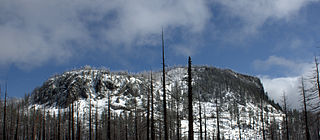
Hogg Rock is a tuya volcano and lava dome in the Cascade Range of northern Oregon, United States, located close to Santiam Pass. Produced by magma with an intermediate andesite composition, it has steep slopes and thick glassy margins. Hogg Rock exhibits normal magnetic polarity and is probably about 80,000 years old.

William Henry Mathews (1919–2003) was a Canadian geologist, volcanologist, engineer, and professor. He is considered a pioneer in the study of subglacial eruptions and volcano-ice interactions in North America. Many of his publications continue to be regarded as classics in their field.
Tuya Lake, located in northwestern British Columbia, Canada, presumably derives its name from the presence of nearby steep-sided, flat-topped volcanoes, known as tuyas. The lake is situated just south of Tuya Butte at a latitude of about 59 degrees North and a longitude of about 131 degrees West.

The volcanic history of the Northern Cordilleran Volcanic Province presents a record of volcanic activity in northwestern British Columbia, central Yukon and the U.S. state of easternmost Alaska. The volcanic activity lies in the northern part of the Western Cordillera of the Pacific Northwest region of North America. Extensional cracking of the North American Plate in this part of North America has existed for millions of years. Continuation of this continental rifting has fed scores of volcanoes throughout the Northern Cordilleran Volcanic Province over at least the past 20 million years and occasionally continued into geologically recent times.
The Tuya River is a major tributary of the Stikine River in northwest part of the province of British Columbia, Canada. From its source at High Tuya Lake in Tuya Mountains Provincial Park just south of Ash Mountain, the highest peak of the Tuya Range, the Tuya River flows south about 200 km (120 mi) to meet the Stikine River in the Grand Canyon of the Stikine. The Tuya River's main tributary is the Little Tuya River. The Tuya River divides the Tanzilla Plateau on the east from the Kawdy Plateau, to the northwest, and the Nahlin Plateau, to the southwest. All three are considered sub-plateaus of the Stikine Plateau. The Tuya River's watershed covers 3,575 km2 (1,380 sq mi), and its mean annual discharge is estimated at 36.9 m3/s (1,300 cu ft/s). The mouth of the Tuya River is located about 24 km (15 mi) northeast of Telegraph Creek, British Columbia, about 67 km (42 mi) southwest of Dease Lake, British Columbia, and about 210 km (130 mi) east of Juneau, Alaska. The Tuya River's watershed's land cover is classified as 35.7% shrubland, 31.4% conifer forest, 14.0% mixed forest, 7.2% herbaceous, and small amounts of other cover.
The Little Tuya River is a tributary of the Tuya River in northwest part of the province of British Columbia, Canada. It flows generally south and east about 71 km (44 mi) to join the Tuya River near Cariboo Meadows. The Little Tuya River's watershed covers 569 km2 (220 sq mi), and its mean annual discharge is an estimated 6.69 m3/s (236 cu ft/s).