Twin Caves

Last updated
Twin Caves boat tour Twincave.jpg
Twin Caves boat tour

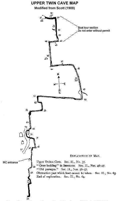
Twin Caves is a pair of cave entrances connected by a short river at the bottom of a sinkhole within the boundaries of Spring Mill State Park in Lawrence County, Indiana. [1] [2] The river is an exposed section of a mostly-underground stream that originates as Mosquito Creek several miles southeast of the park, which sinks into the Upper Twin Cave system. The stream then comes out briefly at Twin Caves, and flows into the Lower Twin Cave, re-emerging briefly at Bronson Cave shortly to the northwest, then flowing into the Shawnee Cave System. The stream finally emerges at the Donaldson Cave entrance as a short tributary of Mill Creek, still within the park.

The park offers boat tours from Twin Caves, into the southern cave entrance (Upper Twin Cave [3] ). The tours last 20 minutes and go upstream about 500 feet (150 m) into the cave, then turn around due to the rest of the cave system belonging to the Indiana Karst Conservancy. [4] The tours are operated by the Indiana Department of Natural Resources and are seasonal from Memorial Day to October.

The Shawnee (Bronson-Donaldson) Cave and Upper Twin Cave have reopened to registered groups, after a closure of several years due to white nose syndrome (WNS). [5]

Related Research Articles

Subterranean river A river that runs wholly or partly beneath the ground surface

A subterranean river is a river that runs wholly or partly beneath the ground surface – one where the riverbed does not represent the surface of the Earth. It is distinct from an aquifer, which may flow like a river but is contained within a permeable layer of rock or other unconsolidated materials. A river flowing below ground level in an open gorge is not classed as subterranean.

McCormicks Creek State Park

McCormick's Creek State Park is the oldest state park in the U.S. state of Indiana, dedicated on July 4, 1916, as part of the state's centennial celebration. It is located 14 miles (23 km) west of Bloomington in Owen County.

Oregon Caves National Monument and Preserve national monument in the United States

Oregon Caves National Monument and Preserve is a protected area in the northern Siskiyou Mountains of southwestern Oregon in the United States. The 4,554-acre (1,843 ha) park, including the marble cave, is 20 miles (32 km) east of Cave Junction, on Oregon Route 46. The protected area, managed by the National Park Service (NPS), is in southwestern Josephine County, near the Oregon–California border.

Bluespring Caverns cave in United States of America

Bluespring Caverns is a cave system located in Lawrence County, Indiana, approximately 80 miles (128 km) south of Indianapolis. The cave system is a karst and river type cave formation and drains a 15 miles² (38.8 km²) sinkhole plain. The cave contains 21 miles (34 km) of surveyed passages and is most notable for having the longest known subterranean river in the United States with approximately 3 miles (4.8 km) of navigable river.

Spring Mill State Park

Spring Mill State Park is a 1,358-acre (5 km2) state park in the state of Indiana. The park is located to the south of Bloomington, about 3 miles (5 km) east of the city of Mitchell on Indiana Highway 60. It contains a settler's village, the Gus Grissom Memorial, a nature's center, and campgrounds.

Charlestown State Park

Charlestown State Park is an Indiana state park on 5,100 acres (20.64 km2) in Clark County, Indiana, in the United States. The park is on the banks of the Ohio River, 1 mile (2 km) east of Charlestown. It was once part of the Indiana Army Ammunition Plant (INAAP), and was donated in separate parcels to the Indiana state government. In 1993, the state of Indiana was given 859 acres (3.48 km2), and in 1994 was given an additional 1,125 acres (4.55 km2). When the park opened in 1996, it encompassed 2,400 acres (9.7 km2). With an additional 2,600 acres (10.5 km2) given by the INAAP in 2004, the park has 5,100 acres (20.6 km2), making it the third largest state park in Indiana. The park attracts 131,000 people a year.

Clifty Falls State Park

Clifty Falls State Park is an Indiana state park on 1,416 acres (573 ha) in Jefferson County, Indiana in the United States. It is 46 miles (74 km) northeast of Louisville, Kentucky.

OBannon Woods State Park

O'Bannon Woods State Park is a 2,000-acre (8 km2) state park in the state of Indiana, 32 miles (51 km) west of Louisville, KY.

Western Pennsylvania Conservancy non-profit organisation in the USA

The Western Pennsylvania Conservancy (WPC) is a private nonprofit conservation organization founded in 1932 and headquartered in Pittsburgh, PA. WPC has contributed land to 12 state parks and conserved more than a quarter million acres of natural lands. The Conservancy plants and maintains more than 132 gardens in 20 Western Pennsylvania counties, as well as planting thousands of trees through its community forestry program. WPC has protected or restored more than 3,000 miles (4,800 km) of rivers and streams. In 1963, Edgar Kaufmann Jr. entrusted Frank Lloyd Wright's masterwork Fallingwater to the Conservancy. The house was called the most important building of the 20th century by the American Institute of Architects.

Squire Boone Caverns and Village is a cavern exploration attraction in Mauckport, Indiana. The park consists of a one-hour walking tour into the caverns, as well as a working pioneer village and grist mill.

Fourteen Mile Creek river in the United States of America

Fourteen Mile Creek, shown as Fourteenmile Creek on federal maps, is a 22.7-mile-long (36.5 km) creek in Clark County, Indiana, close to Charlestown. It is so named because its mouth on the Ohio River is 14 miles (23 km) upstream from the Falls of the Ohio; similar to how Eighteen Mile Island, Twelve Mile Island, and Six Mile Island got their names. It is navigable for 2.9 miles (4.7 km) from the Ohio River. It is a State Heritage Program Site and a popular canoe trail.

Shawnee Cave is located in Spring Mill State Park in the state of Indiana. Access to the cave is controlled by the Indiana Department of Natural Resources.

Onondaga Cave State Park Cave and Park in Missouri.

Onondaga Cave State Park is a Missouri state park located on the Meramec River approximately 5 miles (8.0 km) southeast of the village of Leasburg. The park was established in 1982. Park activities include cave tours, camping, fishing, hiking, picnicking, and swimming.

Germany Valley valley in West Virginia, United States of America

Germany Valley is a scenic upland valley high in the Allegheny Mountains of eastern West Virginia originally settled by German farmers in the mid-18th Century. It is today a part of the Spruce Knob-Seneca Rocks National Recreation Area of the Monongahela National Forest, although much ownership of the Valley remains in private hands.

Hellhole (cave)

Hellhole is a large and deep pit cave in Germany Valley, eastern West Virginia. It is the 7th longest cave in the United States and is home to almost half of the world's population of Virginia big-eared bats. At 518 feet, Hellhole is the deepest of several caves in the Valley.

Scotts Gulf

Scott's Gulf is a canyon situated along the Caney Fork in White County, Tennessee, in the southeastern United States. The canyon stretches for approximately 18 miles (29 km) as the Caney Fork drops from the top of the Cumberland Plateau down to the eastern Highland Rim. This remote section of the river is home to a wilderness area consisting of a largely undisturbed deciduous forest, numerous waterfalls, caves and other geological formations, and Class IV and Class V whitewater rapids.

The Lost River is a river that rises in Vernon Township, Washington County, Indiana, and discharges into the East Fork of the White River in Lost River Township, Martin County, Indiana. The river's unusual hydrology has led to two of its features being named as National Natural Landmarks.

Rock Bridge Memorial State Park

Rock Bridge Memorial State Park is a geological preserve and public recreation area encompassing 2,273 acres (920 ha), five miles (8.0 km) south of Columbia in Boone County, Missouri. The state park is noted for its excellent examples of karst landforms including the rock bridge, sinkholes, and an underground stream at the cave known as Devil's Icebox. The rock bridge was created by the collapse of a section of a cave which resulted in a small arch of rock being left to form a natural bridge over the creek.

The Milltown Biomass-to-Energy Power Station was proposed as a 28 MWe biomass-to-electrical energy power station to be built near Milltown, Indiana in Crawford County. The project was proposed in December 2008 by Liberty Green Renewables (LGR), based in Georgetown, Indiana.

Metro Cave / Te Ananui Cave

The Metro / Te Ananui Caves are a maze of limestone caves formed by the underground capture of Ananui Creek, a tributary of the Waitakere or Nile River. The caves are located in the Paparoa National Park in New Zealand, managed by the Department of Conservation. Parts of the cave system are accessible by cave tours and rafting, operated by a commercial tour operator out of Charleston.

References

  1. "USGS topo map segment". Mappingsupport CalTopo Hi-res. Retrieved 2017-01-22.
  2. "Spring Mill State Park brochure" (PDF). Indiana DNR. Retrieved 2017-01-22.
  3. "Upper Twin Cave Map". Indiana Karst Conservancy. Retrieved 2017-01-22.
  4. "Shawnee Karst Preserve". The Nature Conservancy. Retrieved 2013-02-17.
  5. "DNR relaxes cave restrictions at two state parks". Indiana Department of Natural Resources. Retrieved 2020-04-03.

Coordinates: 38°43′27.7″N86°24′36.0″W / 38.724361°N 86.410000°W / 38.724361; -86.410000