
Broadway is a road in the U.S. state of New York. Broadway runs from State Street at Bowling Green for 13 mi (21 km) through the borough of Manhattan and 2 mi (3.2 km) through the Bronx, exiting north from New York City to run an additional 18 mi (29 km) through the Westchester County municipalities of Yonkers, Hastings-On-Hudson, Dobbs Ferry, Irvington, and Tarrytown, and terminating north of Sleepy Hollow.

Route 27 is a state highway in New Jersey, United States. It runs 38.53 mi (62.01 km) from U.S. Route 206 (US 206) in Princeton, Mercer County northeast to an interchange with Route 21 and Broad Street in Newark, Essex County. The route passes through many communities along the way, including New Brunswick, Highland Park, Edison, Metuchen, Rahway, and Elizabeth. Route 27 is a two- to four-lane undivided highway for most of its length, passing through a variety of urban and suburban environments. It intersects many roads along the way, including Route 18 in New Brunswick, Interstate 287 (I-287) in Edison, the Garden State Parkway in Woodbridge Township, Route 35 in Rahway, Route 28 in Elizabeth, and U.S. Route 22 in Newark. Route 27 crosses the Raritan River on the Albany Street Bridge, which connects Highland Park on the east with New Brunswick on the west.
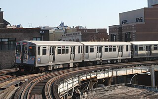
The Red Line is a rapid transit line in Chicago, run by the Chicago Transit Authority (CTA) as part of the Chicago "L" system. It is the busiest line on the "L" system, with an average of 73,273 passengers boarding each weekday in 2021. The route is 26 miles (42 km) long with a total of 33 stations. It runs elevated from the Howard station in the Rogers Park neighborhood on the North Side, through a subway on the Near North Side, Downtown, and the South Loop, and then through the Dan Ryan Expressway median to 95th Street/Dan Ryan in the Lilydale neighborhood on the South Side.
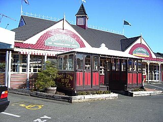
The Dunedin cable tramway system was a group of cable tramway lines in the New Zealand city of Dunedin. It is significant as Dunedin was the second city in the world to adopt the cable car.
The IRT Dyre Avenue Line is a New York City Subway rapid transit line, part of the A Division. It is a branch of the IRT White Plains Road Line in the northeastern section of the Bronx, north of East 180th Street. As of 2013, it has a daily ridership of 34,802.
The Metropolitan Street Railway was the operator of the Metropolitan line in the Toronto area that started out as a local horsecar line and transformed itself into an electric radial line extending to Lake Simcoe, following an old stage coach route. In 1904, the railway was acquired by the Toronto and York Radial Railway (T&YRR) and became the T&YRR Metropolitan Division. In 1922, the City of Toronto acquired the T&YRR and contracted Ontario Hydro to manage the four T&YRR lines including the Metropolitan. In 1927, the TTC took over the operation of the Metropolitan Line to Sutton, and renamed it the Lake Simcoe line. In 1930, the TTC closed the Metropolitan Line but shortly reopened the portion between Glen Echo and Richmond Hill operating it as the North Yonge Railways until 1948.
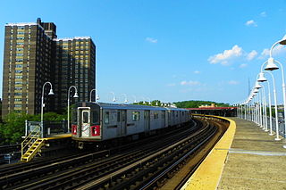
The White Plains Road Line is a rapid transit line of the A Division of the New York City Subway serving the central Bronx. It is mostly elevated and served both subway and elevated trains until 1952. The original part of the line, the part opened as part of the first subway was called the West Farms Division, and the extension north to 241st Street as part of the Dual Contracts was called the White Plains Road Line. Eventually, however, the two parts came to be known as the White Plains Road Line.
Eleventh Avenue is a north–south thoroughfare on the far West Side of the borough of Manhattan in New York City, located near the Hudson River. Eleventh Avenue originates in the Meatpacking District in the Greenwich Village and West Village neighborhoods at Gansevoort Street, where Eleventh Avenue, Tenth Avenue, and West Street intersect. It is considered part of the West Side Highway between 22nd and Gansevoort Streets.

The 512 St. Clair is an east–west streetcar route in Toronto, Ontario, Canada, operated by the Toronto Transit Commission (TTC). It operates on St. Clair Avenue between St. Clair station on the Line 1 Yonge–University subway and Gunns Road, just west of Keele Street.

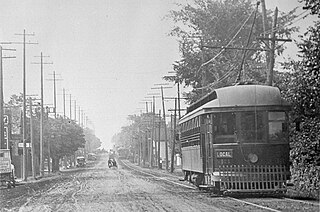
The Chicago North Shore and Milwaukee Railroad, also known as the North Shore Line, was an interurban railroad that operated passenger and freight service over an 88.9-mile (143.1 km) route between the Chicago Loop and downtown Milwaukee, as well as an 8.6-mile (13.8 km) branch line between the villages of Lake Bluff and Mundelein, Illinois. The North Shore Line also provided streetcar, city bus and motor coach services along its interurban route.
In transport engineering nomenclature, a counterflow lane or contraflow lane is a lane in which traffic flows in the opposite direction of the surrounding lanes.

The Blue Line is a light rail line of the RTA Rapid Transit system in Cleveland and Shaker Heights, Ohio, running from Tower City Center downtown, then east and southeast to Warrensville Center Blvd near Chagrin Blvd. 2.6 miles (4.2 km) of track, including two stations, are shared with the rapid transit Red Line, the stations have low platforms for the Blue Line and high platforms for the Red Line. The Blue Line shares the right-of-way with the Green Line in Cleveland, and splits off after passing through Shaker Square. All RTA light rail lines use overhead lines and pantographs to draw power.

The Grand Rapids and Indiana Railroad at its height provided passenger and freight railroad services between Cincinnati, Ohio, and the Straits of Mackinac in Michigan, USA. The company was formed on January 18, 1854.

The Beverley Road station is a local station on the BMT Brighton Line of the New York City Subway. It is located over a private right-of-way at Beverly Road between Marlborough Road/East 15th Street and East 16th Street in the neighborhood of Flatbush, Brooklyn. The station is served by the Q train at all times.

Toronto and Scarboro' Electric Railway, Light and Power Company was established in August 1892 to provide street railway service to the Upper Beaches district within the City of Toronto, Ontario and to the neighbouring Township of Scarborough. Except for two branches, the line ran as a radial along Kingston Road.
The Schomberg and Aurora Railway was a 36 km long railway in Ontario, Canada, running from the town of Schomberg to Oak Ridges, just south of Aurora. It connected Schomberg to the Metropolitan Line of the Toronto and York Radial Railway (T&YRR) tram service running along Yonge Street, and from there into the Toronto city proper. The service ran for 25 years between 1902 and 1927; the rails were pulled up shortly thereafter.

The East Maitland–Morpeth railway is a closed branch railway in New South Wales, Australia.
F was a streetcar line in Los Angeles, California. It was operated by the Los Angeles Railway from 1911 to 1955.

SEPTA's Trolley Route 6, also known as the Ogontz Avenue Line is a former streetcar line and current bus route, operated by SEPTA in Philadelphia, Pennsylvania.
