The name Hanna or Hannah has been used for eleven tropical cyclones worldwide: five in the Atlantic Ocean and six in the Western Pacific Ocean. Hanna has also been used for one extratropical European windstorm.
The name Betty has been used for a total of twenty tropical cyclones worldwide: one in the Atlantic Ocean, two in the South Pacific Ocean, one in the South-West Indian Ocean, and sixteen in the Western Pacific Ocean.
The name Nina has been used for thirteen typhoons in the northwest Pacific Ocean, one tropical cyclone in the northeast Pacific Ocean, and one tropical cyclone in the southwest Pacific.
The name Rita has been used for one tropical cyclone in the Atlantic Ocean and ten tropical cyclones in the western Pacific Ocean.

This timeline documents all the storm formations, strengthening, weakening, landfalls, extratropical transitions, as well as dissipation during the 2008 Pacific typhoon season. The 2008 Pacific typhoon season officially started on January 1, 2008 and ended on January 1, 2009. The first tropical cyclone of the season formed on January 13. The timeline also includes information which was not operationally released, meaning that information from post-storm reviews by the various warning agencies, such as information on a storm that was not operationally warned on, has been included.

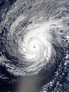
Severe Tropical Storm Maysak, known in the Philippines as Tropical Storm Quinta-Siony, was recognised as the 19th tropical storm by the Japan Meteorological Agency. It was also recognised as the 24th tropical depression and the 22nd tropical storm by the Joint Typhoon Warning Center of the 2008 Pacific typhoon season.
The name Haishen has been used to name four tropical cyclones in the northwestern Pacific Ocean. The name was contributed by China. Its name means "God of sea".
The name Siony has been used in the Philippines by PAGASA in the Western Pacific.
The name Chedeng has been used for five tropical cyclones in the Philippines by PAGASA in the Western Pacific Ocean.

The 2015 Pacific typhoon season was a slightly above average season that produced 27 tropical storms, 18 typhoons, and nine super typhoons. The season ran throughout 2015, though most tropical cyclones typically develop between May and November. The season's first named storm, Mekkhala, developed on January 15, while the season's last named storm, Melor, dissipated on December 17. The season saw at least one named tropical system forming in each of every month, the first time since 1965. Similar to the previous season, this season saw a high number of super typhoons. Accumulated cyclone energy (ACE) during 2015 was extremely high, the third highest since 1970, and the 2015 ACE has been attributed in part to anthropogenic warming.

Typhoon Mitag, known in the Philippines as Typhoon Basyang, was the first super typhoon on record in the month of March. The second storm of the 2002 Pacific typhoon season, Mitag developed from a trough near the equator on February 25 near the Federated States of Micronesia (FSM). It moved westward through the archipelago and intensified into a typhoon before passing near Yap on March 2. High winds and heavy rainfall affected the state, resulting in an islandwide power outage and destroying hundreds of houses. Mitag caused severe crop damage that resulted in food shortages. The rainfall and storm surge flooded much of the coastline as well as Yap's capital, Colonia. Damage totaled $150 million, mostly from crop damage. There was one death related to the storm's aftermath.

The 2020 Pacific typhoon season was a slightly below average season in the annual cycle of tropical cyclone formation in which 23 tropical storms and 10 typhoons formed in the western Pacific Ocean. It was also the fifth-latest start in the basin on record, slightly behind 1973, and was the first to start that late since 2016. The first half of the season was unusually inactive, with only four systems, two named storms and one typhoon at the end of July. Additionally, the JTWC recorded no tropical cyclone development in the month of July, the first such occurrence since reliable records began. The season's first named tropical cyclone, Vongfong, developed on May 8, while the season's last named tropical cyclone, Krovanh, dissipated on December 24. However, the season's last system was an unnamed tropical depression which dissipated on December 29. The 2020 Pacific typhoon season was less active than the 2020 Atlantic hurricane season, which has only happened twice before: in 2005 and 2010.
This timeline documents all of the events of the 2015 Pacific typhoon season. Most of the tropical cyclones formed between May and November. The scope of this article is limited to the Pacific Ocean, north of the equator between 100°E and the International Date Line. This area, called the Western Pacific basin, is the responsibility of the Japanese Meteorological Agency (JMA). They host and operate the Regional Specialized Meteorological Center (RSMC), located in Tokyo. The Japanese Meteorological Agency (JMA) is also responsible for assigning names to all tropical storms that are formed within the basin. However, any storm that enters or forms in the Philippine Area of Responsibility (PAR) will be named by the Philippine Atmospheric, Geophysical and Astronomical Services Administration (PAGASA) using a local name. Also of note - the Western Pacific basin is monitored by the United States' Joint Typhoon Warning Center (JTWC), which gives all Tropical depressions a number with a "W" suffix.
Typhoon Maysak, known in the Philippines as Typhoon Chedeng, was the most powerful pre-April tropical cyclone on record in the Northwestern Pacific Ocean. The fourth named storm of the 2015 Pacific typhoon season, Maysak originated as a tropical depression on March 26. The next day, the Japan Meteorological Agency (JMA) upgraded the depression to a tropical storm and assigned it the name Maysak. According to the JMA, Maysak became the second typhoon of the year on March 28. The typhoon explosively intensified into a Category 5 super typhoon on March 31, passing near the islands of Chuuk and Yap in the Federated States of Micronesia. After maintaining that intensity for 18 hours, Maysak weakened, made landfall over the Philippine island of Luzon as a minimal tropical storm, and dissipated shortly afterwards.

Typhoon Bavi, known in the Philippines as Severe Tropical Storm Igme, was a powerful tropical cyclone that made landfall in North Korea in August 2020. The eighth named storm and third typhoon of the 2020 Pacific typhoon season, Bavi formed from a low pressure area depression on August 21 to the north of the Philippines and strengthened into a tropical storm on August 22. Bavi gradually strengthened as it skirted Taiwan and Okinawa, and became a typhoon on August 24. Passing over warm waters, Bavi turned to northwest and reached its peak intensity near Jeju Island on August 26. Thereafter, increasing wind shear and cooler waters caused Bavi to quickly weaken. Bavi made landfall in North Korea on August 27, and became an extratropical cyclone shortly thereafter.

Typhoon Maysak, known in the Philippines as Typhoon Julian, was a deadly, damaging and powerful tropical cyclone that struck the Ryukyu Islands and the Korean Peninsula in September 2020. The third typhoon of the 2020 Pacific typhoon season, Maysak formed from a tropical disturbance. The disturbance gradually organized, receiving the name Julian from PAGASA as it became a tropical depression. As the depression strengthened, the JMA subsequently named the system Maysak. Maysak rapidly intensified into a strong typhoon before weakening and making landfall in South Korea.

Typhoon Haishen, known in the Philippines as Typhoon Kristine, was a powerful tropical cyclone that became the first super typhoon of the 2020 Pacific typhoon season. Being also the tenth named storm and this season's fifth typhoon, Haishen's origins can be tracked back to a disorganised low pressure area situated near Guam. While the disturbance tracked south-westward and quickly organised, the JTWC issued a Tropical Cyclone Formation Alert (TCFA) on the system, and a day later, on September 1, the system became a tropical depression. The depression strengthened into Tropical Storm Haishen according to the Japan Meteorological Agency as it moved southwestward. At about 12:00 UTC on September 2, the Philippine Atmospheric, Geological and Astronomical Services Administration indicated that Haishen had entered the Philippine Area of Responsibility and was subsequently named Kristine. Later that day, Haishen became a typhoon. Intensification on September 3 was significant. Drifting northwestward into extremely favorable conditions, Haishen became a category 3-equivalent typhoon, acquiring a pinhole eye, before undergoing an eyewall replacement cycle (EWRC). Strengthening resumed soon after and the JTWC assessed wind speeds of 135 kt as it peaked as a powerful Category 4 super typhoon and had attained a new, symmetrical, clear eye.