
Tyrone
Location of Tyrone in Ontario
Tyrone is a community in Ontario, Canada, incorporated in the municipality of Clarington. It was named after County Tyrone in Ireland. Tyrone is located about 12 km north of the town of Bowmanville. [1]
Tyrone is a community in Ontario, Canada, incorporated in the municipality of Clarington. It was named after County Tyrone in Ireland. Tyrone is located about 12 km north of the town of Bowmanville. [1]

After Darlington township was surveyed in 1792, settlement in the area around the current village of Tyrone began in about 1810. By 1840, there were a number of settlers in the area; most were either Irish or from Devon and Cornwall. The two groups met for a lacrosse match; the Irish team won, and so were given the privilege of naming the newly formed village. [2]
In 1867, Robert McLaughlin built two cutters on his family farm just to the west of Tyrone. Shortly after he founded the McLaughlin Carriage Works, which grew to be the largest carriage maker in the British Empire. [3]
In 1880, there were about 300 people living in the village. There were three stores and a mill. [1]
The Tyrone mill, erected in 1846, continues to grind grain and mill lumber using water power. [4] In recent years it is a tourist stop, selling apple cider, local preserves, and freshly baked bread and doughnuts. There is also a blacksmith shop. [5]
| Climate data for Tyrone | |||||||||||||
|---|---|---|---|---|---|---|---|---|---|---|---|---|---|
| Month | Jan | Feb | Mar | Apr | May | Jun | Jul | Aug | Sep | Oct | Nov | Dec | Year |
| Record high °C (°F) | 11.5 (52.7) | 11.5 (52.7) | 22.5 (72.5) | 29.5 (85.1) | 31.5 (88.7) | 34.5 (94.1) | 35 (95) | 33.3 (91.9) | 32.5 (90.5) | 27.8 (82.0) | 20 (68) | 18 (64) | 35 (95) |
| Mean daily maximum °C (°F) | −3.1 (26.4) | −2.1 (28.2) | 3.1 (37.6) | 10.7 (51.3) | 18.1 (64.6) | 23 (73) | 25.7 (78.3) | 24.6 (76.3) | 20 (68) | 13 (55) | 5.9 (42.6) | −0.1 (31.8) | 11.6 (52.9) |
| Daily mean °C (°F) | −7.7 (18.1) | −6.7 (19.9) | −1.6 (29.1) | 5.6 (42.1) | 12.3 (54.1) | 17.1 (62.8) | 19.9 (67.8) | 18.9 (66.0) | 14.5 (58.1) | 8 (46) | 2.1 (35.8) | −4.1 (24.6) | 6.5 (43.7) |
| Mean daily minimum °C (°F) | −12.3 (9.9) | −11.3 (11.7) | −6.3 (20.7) | 0.5 (32.9) | 6.5 (43.7) | 11.2 (52.2) | 14 (57) | 13.2 (55.8) | 9 (48) | 3 (37) | −1.7 (28.9) | −8.1 (17.4) | 1.5 (34.7) |
| Record low °C (°F) | −33 (−27) | −30.6 (−23.1) | −27 (−17) | −17.2 (1.0) | −3.9 (25.0) | −0.6 (30.9) | 3.3 (37.9) | 1.1 (34.0) | −3 (27) | −9.4 (15.1) | −17.2 (1.0) | −31.5 (−24.7) | −33 (−27) |
| Average precipitation mm (inches) | 80.3 (3.16) | 59.5 (2.34) | 72.1 (2.84) | 79.2 (3.12) | 75.7 (2.98) | 80 (3.1) | 76.1 (3.00) | 88.6 (3.49) | 93.7 (3.69) | 77.5 (3.05) | 91.8 (3.61) | 78.4 (3.09) | 952.8 (37.51) |
| Source: Environment Canada [6] | |||||||||||||
McLaughlin Motor Car Company Limited was a Canadian manufacturer of automobiles headquartered in Oshawa, Ontario. Founded by Robert McLaughlin, it once was the largest carriage manufacturing factory in the British Empire.

Oshawa is a city in Ontario, Canada, on the Lake Ontario shoreline. It lies in Southern Ontario, approximately 60 km (37 mi) east of Downtown Toronto. It is commonly viewed as the eastern anchor of the Greater Toronto Area and of the Golden Horseshoe. It is the largest municipality in the Regional Municipality of Durham. The name Oshawa originates from the Ojibwa term aazhawe, meaning "the crossing place" or just "a cross".

Clarington is a lower-tier municipality in the Regional Municipality of Durham in Ontario, Canada. It was incorporated in 1973 as the town of Newcastle with the merging of the town of Bowmanville, the Village of Newcastle and the townships of Clarke and Darlington, and was established on January 1 1974. In 1993, the town was renamed Clarington, a blending of the names of the two former townships. Darlington today is largely suburban, while Clarke remains largely rural. Bowmanville is the largest community in the municipality and is the home of the municipal offices.

Hampton is a community located in the municipality of Clarington, Ontario, Canada. It was the location of the offices of Darlington Township until 1974 when it became part of the newly created Town of Newcastle as part of the municipal government restructuring that created the Regional Municipality of Durham.
Bowmanville is a town of approximately 40,000 people located in the Municipality of Clarington, Durham Region, Ontario, Canada. It is approximately 75 km (47 mi) east of Toronto, and 15 km (9.3 mi) east of Oshawa along Highway 2. Bowmanville was first incorporated as a town in 1858, but later incorporated with the neighbouring townships of Clarke and Darlington in 1974 forming the Town of Newcastle, which was renamed in 1994 to the Municipality of Clarington. Bowmanville is part of the Greater Toronto Area.
Durham County is an historic county in Ontario, Canada. It was named for the English County Durham and city of Durham. It was created in 1792 but was later merged Northumberland County to form the United Counties of Northumberland and Durham. In 1974, the two counties were split and reorganized, with the former portions of Durham County reorganized into the Regional Municipality of Durham.

Courtice is a community in Ontario, Canada, about 60 km (37 mi) east of Toronto, within the Municipality of Clarington. Adjacent to Oshawa, it is west of Bowmanville, which is also part of Clarington. Courtice Road connects with Highway 401 at Interchange 425, providing arterial access to the community. Darlington Provincial Park is located just south of Courtice.
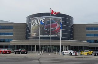
General Motors of Canada Company, commonly known as GM Canada, is the Canadian subsidiary of US-based company General Motors. It is headquartered in Oshawa, Ontario, Canada.

Durham is a provincial electoral district in Ontario, Canada, that has been represented in the Legislative Assembly of Ontario since 1999 and from 1926 to 1975.

Roseville is a community in Ontario, Canada located at 43°20′35″N80°28′31″W. It is within the rural township of North Dumfries, which forms part of the Region of Waterloo, and is located between Ayr, Kitchener and Highway 401.
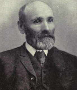
Robert McLaughlin was a Canadian industrialist and businessman. He founded McLaughlin Carriage then McLaughlin Motor Car Company which later became part of General Motors Canada.

The Township of Mariposa was a municipality located in the southwest corner of the former Victoria County, now the city of Kawartha Lakes, in the Canadian province of Ontario. The other municipal neighbours of Mariposa are Ops and Fenelon on the east, Eldon on the north, Brock on the west, and Scugog on the south, with the latter two located in the Durham Regional Municipality. The former township includes the communities of Little Britain, Manilla, Mariposa, Valentia, and Oakwood. Today, most of the former township is represented in the City of Kawartha Lakes by the Ward 8 Councillor, John Pollard, and Ward 4 Councillor Andrew Veale.

Stone Mills is a lower-tier township north of Greater Napanee in Lennox and Addington County, Ontario, Canada. According to the 2016 census, the township has a population of 7,702.
Caledon Township, Ontario was a historic incorporated township and is a present-day geographic township in the modern Region of Peel, Ontario, Canada. The township forms the northwest section of Caledon, Ontario.
View Lake is a small village located in Ontario, Canada. It is situated on the boundary of the Regional Municipality of Durham and the city of Kawartha Lakes, on the southern shores of Lake Scugog.
Lang Pioneer Village Museum is a living history museum located in the hamlet of Lang in Peterborough County, Ontario. It was established in 1967 by the County of Peterborough. Lang Pioneer Village is situated on the shores of the historic Indian River. Lang Pioneer Village is an "outdoor museum" featuring more than 30 restored and furnished buildings, many of which were donated from the surrounding townships. The buildings, constructed between 1820 and 1910, are interpreted by costumed villagers portraying authentic 19th-century pioneer life. Since 2014 the Museum has been the site of the Aabnaabin Encampment, a pre-colonization representation of a Michi Saagiig camp where the story of the First Nations history and culture of the region is told by indigenous interpreters. Lang Pioneer Village Museum is owned and operated by the County of Peterborough.
Mitchell Corners is a community in Ontario, Canada. It is located within the municipality of Clarington, directly north of Courtice, at the intersection of Trulls Road and Taunton Rd. It was named after the early settlers to the area.
Ganaraska Region is a region located in Ontario, Canada, stretching along the shore of Lake Ontario for approximately 45 kilometres (28 mi) and about 15 kilometres (9.3 mi) wide. It contains watersheds, covering an area of 700 square kilometres (270 sq mi) from Wilmot Creek in Clarington to eastside of Cobourg and from the southern shore of Rice Lake down to Lake Ontario. This expansive area includes seven municipalities in whole or in part: Township of Cavan Monaghan, Town of Cobourg, Township of Alnwick/Haldimand, Township of Hamilton, Municipality of Port Hope, City of Kawartha Lakes, Municipality of Clarington.

The Cream of Barley Mill is a historic mill in the town of Bowmanville, Municipality of Clarington, Ontario, Canada.

Canton is a hamlet in southeastern Ontario, a few kilometers north of Port Hope. It has a small wooden chapel built in 1832, one of the oldest in the region. Canton was once the home of Vincent Massey, the lawyer, diplomat and Governor General of Canada.