
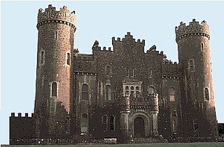
Tyrrellspass Castle [1] is a medieval castle in Tyrrellspass, County Westmeath, Ireland. Dating back to circa 1411, it is the only remaining castle of the Tyrrells who came to Ireland around the time of the Norman Invasion.
Tyrrellspass Castle [1] is a medieval castle in Tyrrellspass, County Westmeath, Ireland. Dating back to circa 1411, it is the only remaining castle of the Tyrrells who came to Ireland around the time of the Norman Invasion.
The castle is approximately 20 metres high and follows the general pattern of tower houses: stone-built, essentially defensive and comprising a series of superimposed chambers. The original spiral staircase and one of the original roof beams dating from 1280 can still be seen today as an exposed beam in 'the lounge' restaurant. Alongside the entrance door is a murder-hole through which intruders could be attacked. [2]
Tyrrellspass is the modern name for Fartullagh,[ citation needed ] where in 1597 Captain Richard Tyrrell, a chief ally of Hugh O'Neill in the Nine Years' War, won a major victory against English crown forces in what has become known as the Battle of Tyrrellspass. [3]
During the Cromwellian invasion of 1650, it is said the castle occupants suffered a great deal and many were executed. The castle and surrounding land was acquired soon after by the Rochfort family, who became the Earls of Belvedere. In 1796 the 2nd earl leased the castle to the army as a barracks. [4] In 1850, ownership passed to Charles Brinsley Marlay, grandson of the 1st earl's only daughter, after whom it passed to Lieut.-Colonel Charles Howard-Bury, the explorer. He sold off the houses on the estate.[ citation needed ]
After a tumultuous history of intrusion, the castle was extensively restored by Phillip Ginnell[ who? ] in the 1970s.[ citation needed ]
During the early 1990s, the building was converted into a modern restaurant. Today it operates under the name Tyrrellspass Castle Restaurant. [5] It also hosts medieval banquets.
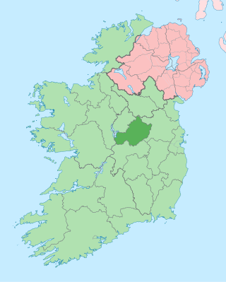
County Westmeath is a county in Ireland. It is in the province of Leinster and is part of the Eastern and Midland Region. It formed part of the historic Kingdom of Meath, which was named Mide because the kingdom was located in the geographical centre of Ireland. Westmeath County Council is the administrative body for the county, and the county town is Mullingar. At the 2022 census, the population of the county was 95,840.

Dunamase or the Rock of Dunamase is a rocky outcrop in County Laois, Ireland. Rising 46 metres (151 ft) above a plain, it has the ruins of Dunamase Castle, a defensive stronghold dating from the early Hiberno-Norman period with a view across to the Slieve Bloom Mountains. It is near the N80 road between the towns of Portlaoise and Stradbally.

Belvedere House and Gardens is a country house located approximately 8 kilometres (5 mi) from Mullingar, County Westmeath in Ireland on the north-east shore of Lough Ennell. It was built in 1740 as a hunting lodge for Robert Rochfort, 1st Earl of Belvedere by architect Richard Cassels, one of Ireland's foremost Palladian architects.

Tyrrellspass is a Georgian village in County Westmeath, Ireland. It is 81 kilometres (50 mi) from Dublin, in the south of the county on the R446 road. Tyrrellspass won the Irish Tidy Towns Competition in 1969. As of the census in April 2016, the population of Tyrrellspass was 483.

Tullynally Castle, also known as Pakenham Hall, is a country house situated some 2 km from Castlepollard on the Coole village road in County Westmeath, Ireland. The Gothic-style building has over 120 rooms and has been home to the Pakenham family for over 350 years.

The villages of Killucan and Rathwire are co-located in the east of County Westmeath, Ireland. They have a combined population of 1,370 according to the 2016 census. Killucan is on the R156 road about 15 km (9.3 mi) from Mullingar and 60 km (37 mi) from Dublin.

Knockdrin is a townland and electoral division that is 5.6 kilometers northeast of Mullingar, in County Westmeath, Ireland. It is the home of the Westmeath Hunt, and its most notable building is Knockdrin Castle. The R394 regional road, the main Mullingar to Castlepollard route, runs through the area.

Castletown Geoghegan is a village in County Westmeath, Ireland, and lies south west of Lough Ennell near the county town of Mullingar. It is around 13 km south-west of Mullingar and 19 km north of Tullamore. Castletown was the seat of the Geoghegan family of the medieval Barony of Moycashel in County Westmeath.
Clonyn Castle also known as Delvin Castle, is a Victorian country house situated in Delvin, County Westmeath, Ireland some 18 km from Mullingar along the N52. It is a square, symmetrical, two-storey castle-like building of cut limestone with four tall, round corner towers at each corner. The interior has a large two-storey hall with a gallery and arcading. It was one of the last Victorian baronial castles to be built in Ireland.
Ballinlough Castle is a 17th-century country house situated near the rural town of Clonmellon in County Westmeath, Ireland on a hill overlooking two of the Westmeath lakes. It is the home of Sir Nicholas and Lady Nugent.
Events from the year 1639 in Ireland.
Portlick Castle is a late medieval tower house castle near the village of Glasson, County Westmeath, Ireland. It is located approximately 6 miles from Athlone on the shores of Lough Ree. It comprises a square late medieval 4-storey stone tower with an attached 2-storey Georgian wing and Victorian tower.

Richard Tyrrell was an Anglo-Irish Lord of Norman ancestry who commanded rebel Irish forces in the Irish Nine Years War, most notably at the Siege of Kinsale. He was considered one of Hugh O'Neill's most accomplished allies.

Castlelost Castle is a ruined motte-and-bailey castle located in the townland of Castlelost, just north of Rochfortbridge in County Westmeath, Ireland. The castle dates to the Norman invasion of Ireland, with some sources dating its construction to the late 12th century and associating it with Hugh Tyrrel. The castle remained within the Tyrrel family through the 16th century. During the 17th century, the castle and surrounding lands were lost by the Tyrrels during the Irish Rebellion of 1641 and subsequent Cromwellian conquest of Ireland.
Fartullagh, previously Tyrrells country, is a barony in south–east County Westmeath, in Ireland. It was formed by 1542. It is bordered by County Offaly to the south and three other baronies: Moycashel, Moyashel and Magheradernon and Farbill.

Clontycarnaghan is a townland in the civil parish of Templeport, County Cavan, Ireland. It lies in the Roman Catholic parish of Templeport and barony of Tullyhaw.
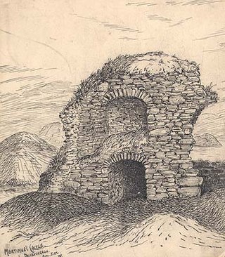
Mortimer's Castle is a castle and National Monument located in County Westmeath, Ireland.

Charles Brinsley Marlay was an Anglo-Irish landowner and art collector.

Doon Hill is a volcanic plug in the townland of Bunowen More, in the barony of Ballynahinch, near Ballyconneely in County Galway, Ireland. The hill, which is 67 m high, is a prominent landscape feature on the Errismore peninsula. Fishermen use Doon Hill as a landmark to guide them into Bunowen Pier at Aillebrack. The Irish name for the hill, dún, means "fortress", possibly indicating an earlier fort on top of the hill.
Castlelost West is a townland in County Westmeath, Ireland. The townland is located in the civil parish of the same name. The R446 regional road runs through the south of the area. The townland of Castlelost lies to the east and contains the town of Rochfortbridge. The town of Tyrrellspass stands to the west of the townland.