
Haifa District is an administrative district surrounding the city of Haifa in Israel. The district is one of the seven administrative districts of Israel, and its capital is Haifa. The district land area is 864 km2 (299.3 mi2).
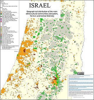
The Tel Aviv District is the geographically smallest yet also the most densely populated of the six administrative districts of Israel, with a population of 1.35 million residents. It is 98.9% Jewish and 1.10% Arab.

The Misgav Regional Council is a regional council in the Galilee in northern Israel. The regional council is home to 27,421 people, and comprises 35 small towns, mostly community settlements but also several kibbutzim and moshavim. The population of 29 of these is primarily Jewish, and 6 are Bedouin. The region is noted for the way that communities and non-Jewish communities live side-by-side.

The Menashe Regional Council is a regional council near the city of Hadera, on Israel's north-central coastal plain in the southern Haifa District. It is named after the tribe of Menashe which had been allotted this region according to the Book of Joshua (17:1-10).
Metu Zuria is a woreda in Oromia Region, Ethiopia. Part of the Illubabor Zone, Metu Zuria is bordered on the south by Ale, on the southwest by Bure, on the west by the Kelem Welega Zone, on the north by Darimu, on the northeast by Supena Sodo, on the east by Yayu and on the southeast by Southern Nations, Nationalities and Peoples Region. The former Metu woreda was separated for Bicho, Bilo Nopha and Metu Zuria woredas and Metu Town.
The Lower Galilee Regional Council is a regional council in the Northern District of Israel. Lower Galilee Regional Council encompasses most of the settlements in the Lower Galilee with a population of 11,300 (2014), including three kibbutzim, ten moshavim and two community settlements, along with two youth villages located in its administrative territory.

The Mateh Asher Regional Council is a regional council in the western Galilee of northern Israel. It is named after the Tribe of Asher which had been allotted the region in antiquity according to the Book of Joshua (19:24–31). It was founded in 1982 as a merger of three regional councils: Ga'aton, Na'aman and Sulam Tzor. The council's offices are located on Highway 4, between Regba and Lohamei HaGeta'ot.
Hof HaCarmel Regional Council is a regional council located in the northern Israeli coastal plain. The council serves a large area, stretching from Tirat HaCarmel in the north to Caesarea in the south. Its offices are located in Ein Carmel to the south of Haifa. The head of the council is Asif Izek, elected in 2018.

The Max Stern Yezreel Valley College is an academic college located in the Jezreel Valley of Israel, between the cities Afula and Nazareth, and next to Kfar Gid'on, Tel Adashim and Mizra.

Gameleira is a city in Pernambuco, Brazil. The name Gameleira is derived from the large number of Gameleira trees that were growing in the region. The city is 99 km away from Recife, the capital city of Pernambuco. Gameleira has a bus terminal, a public library, two state schools and several municipal schools.

Highway 71 is an east-west highway that passes through the eastern Jezreel Valley and the Beit She'an Valley, below the north slopes of the Gilboa mountains, in northern Israel. The road follows a path parallel to the Harod Creek in the Harod Valley and to the Jezreel Valley railway. It is 35 kilometres (22 mi) long and leads from Afula in the west, via Beit She'an, to the Jordan River Border Crossing in the east. The Navot interchange located approximately 10 km southeast of Afula provides a shortcut via Route 675 through the Ta'anakh region from Highway 71 and Beit She'an to Highway 65 and central Israel.

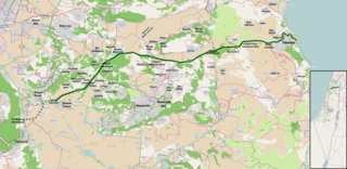
Highway 70 is a highway, 44 km in length, running through the Western Galilee region in the Northern District of Israel. It connects the Lower Galilee to Kiryat Ata and Shlomi near Israel's border with Lebanon.
Highway 77 is an east-west highway in northern Israel. It crosses the Lower Galilee in the region of the Beit Netofa Valley. The road leads from the Tel Qashish Interchange nearby Yokneam Illit to Tiberias. It is 48km long. Its western section, from the Tel Qashish Interchange to the Golani Interchange is a freeway.

Guadalupe National Forest is a former National Forest in southern New Mexico. The Forest was originally established on April 19, 1907 by a Proclamation issued by President Theodore Roosevelt. Led by inaugural Supervisor J. H. Kinney, the forest was initially based in Carlsbad, New Mexico, but within a year the headquarters was moved to Alamogordo. Soon after, on July 2, 1908, President Roosevelt issued Executive Order 908. which consolidated the Guadalupe with the nearby Sacramento National Forest to create the Alamo National Forest. Arthur M. Neal, the last supervisor of the independent Guadalupe forest became the initial supervisor for the new Alamo National Forest, with his headquarters in Alamogordo. Under this new administrative scheme the former Guadalupe National Forest was renamed the Carson Seep Ranger District of the Alamo National Forest. On June 6, 1917, President Woodrow Wilson issued Executive Order 2633, which disestablished the Alamo National Forest and transferred all of its lands to the Lincoln National Forest. As a result of this order, the Carson Seep Ranger District was renamed to its current designation, the Guadalupe Ranger District of the Lincoln National Forest, with its headquarters in Carlsbad.
Gulf of Mersin is one of the widest gulfs in Turkey. It is in the northeast of the Mediterranean Sea between the gulfs of İskenderun and Antalya.

Nahal Amud, also known as the Wadi al-Amud, is a stream in the Upper Galilee region of Israel that flows into the Sea of Galilee.
Babo Gambela is one of the 180 woredas of the Oromia Region of Ethiopia. Part of the Mirab Welega Zone, it is bounded by Jarso and Nejo in the east, Mana Sibu and Kiltu Kara in the north, Begi in the west, Kondala and Kelem Welega Zone in the south. This woreda was created from a portion of Jarso woreda; Babo Dabeka is its administrative center.
Kampala–Busunju Expressway is a planned road in the Central Region of Uganda. The road would connect the county's capital city, Kampala, to the town of Busunju in Mityana District.