The National Geodetic Survey (NGS), formerly the United States Survey of the Coast (1807–1836), United States Coast Survey (1836–1878), and United States Coast and Geodetic Survey (USC&GS) (1878–1970), is a United States federal agency that defines and manages a national coordinate system, providing the foundation for transportation and communication; mapping and charting; and a large number of applications of science and engineering. Since its foundation in its present form in 1970, it has been part of the National Oceanic and Atmospheric Administration (NOAA), of the United States Department of Commerce.

William Pope McArthur was an American naval officer and hydrologist who was involved in the first surveys of the Pacific Coast for the U.S. Coast and Geodetic Survey.

USC&GS Thomas R. Gedney, originally USCS Thomas R. Gedney, was a survey ship in service in the United States Coast Survey from 1875 to 1878 and in the United States Coast and Geodetic Survey from 1878 to 1915.

USC&GS Pioneer was a survey ship that served in the United States Coast and Geodetic Survey from 1922 to 1941. She was the first ship of the Coast and Geodetic Survey to bear the name.
USC&GS Arago was a steamer that served as a survey ship in the United States Coast Survey from 1871 to 1878 and in the United States Coast and Geodetic Survey from 1878 to 1890. She was the second ship of the Coast Survey or Coast and Geodetic Survey to bear the name.
USCS, later USC&GS, Barataria was a steamer that served as a survey ship in the United States Coast Survey from 1867 to 1878 and in the United States Coast and Geodetic Survey from 1878 to 1885.

USS Surveyor was an armed steamer that served in the United States Navy from 1917 to 1919. Prior to her U.S. Navy service, she operated as the survey ship USC&GS Surveyor for the United States Coast and Geodetic Survey in 1917, and she returned to that role after her U.S. Navy decommissioning, remaining in Coast and Geodetic Survey service until 1956.

NOAA Ship Surveyor was an oceanographic survey ship in commission in the National Oceanic and Atmospheric Administration (NOAA) from 1970 until 1995. Prior to her NOAA career, she was in commission in the United States Coast and Geodetic Survey from 1960 to 1970 as USC&GS Surveyor. She was the second and last Coast and Geodetic Survey ship named Surveyor and has been the only NOAA ship thus far to bear the name.

USC&GS Yukon was a steamer that served as a survey ship in the United States Coast and Geodetic Survey from 1898 to 1923. She was the second and last Coast and Geodetic Survey ship to bear the name.
USCS Baton Rouge, later USC&GS Baton Rouge, was a stern-wheel steamer that served as a survey ship in the United States Coast Survey from 1875 to 1878 and in the United States Coast and Geodetic Survey from 1878 to 1880.

USC&GS Matchless was a wood, two masted schooner that served as a survey ship in the United States Coast and Geodetic Survey from 1885 to 1919. She was the only Coast and Geodetic Survey ship to bear the name and the last sailing vessel owned and operated by the Survey.

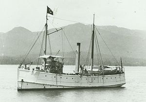
USC&GS Taku was a United States Coast and Geodetic Survey survey ship in service from 1898 to 1917. She was the only Coast and Geodetic Survey ship to bear the name.

USC&GS Isis was a survey ship that served in the United States Coast and Geodetic Survey from 1915 to 1917 and from 1919 to 1920.
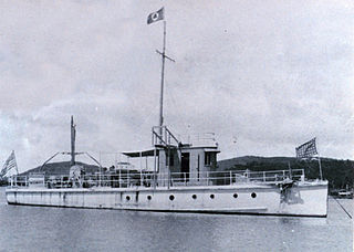
USC&GS Marindin was a launch that served as a survey ship in the United States Coast and Geodetic Survey from 1919 to 1944. She was the only Coast and Geodetic Survey ship to bear the name.
USCS, later USC&GS, Fathomer was a steamer that served as a survey ship in the United States Coast Survey from 1871 to 1878 and in the United States Coast and Geodetic Survey from 1878 to 1881. She was the only Coast Survey and first Coast and Geodetic Survey ship of the name.
USC&GS McArthur was the name of two United States Coast and Geodetic Survey ships, and may refer to:

NOAAS Davidson was a survey ship in commission in the National Oceanic and Atmospheric Administration (NOAA) from 1970 to 1989. Prior to her NOAA service, she was in commission in the United States Coast and Geodetic Survey from 1967 to 1970 as USC&GS Davidson, the second Coast and Geodetic Survey ship of the name. She was the only sister ship of NOAAS McArthur (S 330).
USC&GS Westdahl was a survey ship that served in the United States Coast and Geodetic Survey from 1929 to 1946.

USC&GS Cosmos was a survey launch in service in the United States Coast and Geodetic Survey from 1887 to 1927.

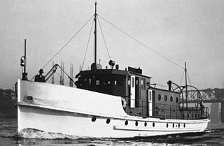
USC&GS Gilbert was a launch that served as a survey ship in the United States Coast and Geodetic Survey from 1930 to 1962.