
Peters Marland is a small village and civil parish in the local government district of Torridge, Devon, England. The parish, which lies about four miles south of the town of Great Torrington, is surrounded clockwise from the north by the parishes of Little Torrington, Merton, Petrockstowe, Buckland Filleigh, Shebbear and Langtree. In 2001 its population was 234, down from the 286 residents it had in 1901.

Heel is a town in the southeastern Netherlands. It has been a part of the municipality of Maasgouw since January 1, 2007. Before, it was a separate municipality covering Heel, Panheel, Beegden and Wessem. Before 1991, the official name of the municipality was Heel en Panheel. In pre-Roman times, this was the location of the Gallic town of Catualium.

Guazapa is a municipality in the San Salvador department of El Salvador.
Berezovo or Beryozovo (Берёзово) is the name of several inhabited localities in Russia.
Troitsk is the name of several inhabited localities in Russia.

Krāslava District was an administrative division of Latvia, located in Latgale region, in the country's east. It was organized into two cities and twenty three parishes, each with a local government authority. The main city in the district was Krāslava.
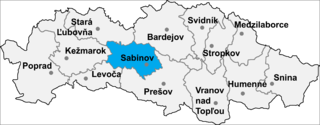
Torysa is a village and municipality in Sabinov District in the Prešov Region of north-eastern Slovakia.
Arevalillo de Cega is a municipality located in the province of Segovia, Castile and León, Spain. According to the 2004 census (INE), the municipality has a population of 42 inhabitants.
Bornhöved is an Amt in the district of Segeberg, in Schleswig-Holstein, Germany. The seat of the Amt is in Bornhöved.
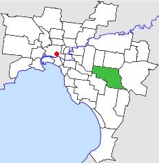
The City of Waverley was a local government area about 20 kilometres (12 mi) east-southeast of Melbourne, the state capital of Victoria, Australia. The city covered an area of 60.86 square kilometres (23.50 sq mi), and existed from 1857 until 1994.
Extreme geographical points of Slovenia:

Pustniki is a village in the administrative district of Gmina Sorkwity, within Mrągowo County, Warmian-Masurian Voivodeship, in northern Poland. It lies approximately 5 kilometres (3 mi) north of Sorkwity, 9 km (6 mi) west of Mrągowo, and 46 km (29 mi) east of the regional capital Olsztyn.

Srbeč is a village and municipality in Rakovník District in the Central Bohemian Region of the Czech Republic.

Pāvilosta Municipality is a municipality in Courland, Latvia. The municipality was formed in 2009 by merging Pāvilosta town, Saka parish and Vērgale parish the administrative centre being Pāvilosta.
Nansen Ice Sheet, or Nansen Ice Shelf, is a 30-mile-long (48 km) by 10-mile-wide (16 km) ice shelf. It is nourished by the Priestley and Reeves Glaciers and abutting the north side of the Drygalski Ice Tongue, along the coast of Victoria Land, Antarctica. This feature was explored by the South Magnetic Polar Party of the British Antarctic Expedition, 1907-09 and by the Northern Party of the British Antarctic Expedition, 1910-13. Frank Debenham, geologist with the latter expedition, applied the name Nansen Sheet as the feature is adjacent to Mount Nansen, the dominating summit in the area.
SM U-165 was one of the 329 submarines serving in the Imperial German Navy in World War I. U-165 was engaged in the naval warfare and took part in the First Battle of the Atlantic. She sank on her way to surrender on 18 November 1918 at position 53°10′N8°53′E.
Tukingassoq Island is an island of Greenland. It is located in Baffin Bay in the Upernavik Archipelago.

Loxhore is a small village, civil parish and former manor in the local government district of North Devon in the county of Devon, England. The parish, which lies about five miles north-east of the town of Barnstaple, is surrounded clockwise from the north by the parishes of Arlington, Bratton Fleming and Shirwell. In 2001 its population was 153, down from the 202 residents it had in 1901.
Tahua is one of Duff Islands archipelago, located in the Temotu Province of the Solomon Islands is the Pacific Ocean. The estimated terrain elevation above sea level is some 23 metres. The island is inhabited.


