Related Research Articles

Vilhjalmur Stefansson was an Icelandic American Arctic explorer and ethnologist. He was born in Manitoba, Canada, and died at the age of 82.
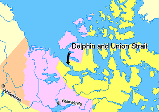
Dolphin and Union Strait lies in both the Northwest Territories and Nunavut, Canada, between the mainland and Victoria Island. It links Amundsen Gulf, lying to the northwest, with Coronation Gulf, lying to the southeast. The southeastern end of the strait is marked by Austin Bay. It gets its name from the two boats used by John Richardson who first explored it in 1826.
The Duke of York Archipelago is an uninhabited island group in the Kitikmeot Region, Nunavut, Canada. It is located in the Coronation Gulf.

Copper Inuit are a Canadian Inuit group who live north of the tree line, in what is now Nunavut's Kitikmeot Region and the Northwest Territories's Inuvik Region. Most historically lived in the area around Coronation Gulf, on Victoria Island, and southern Banks Island.

Ogden Bay is an Arctic waterway in Kitikmeot Region, Nunavut, Canada. It is located in the southern Queen Maud Gulf off Nunavut's mainland. Chester Bay is situated 32 km (20 mi) to the west, Armark is to the east, and the Keith Islands are to the north.
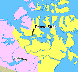
Kiillinnguyaq, formerly the Kent Peninsula, is a large Arctic peninsula, almost totally surrounded by water, in the Kitikmeot Region of Nunavut. Were it not for a 5 mi (8.0 km) isthmus at the southeast corner it would be a long island parallel to the coast. From the isthmus it extends 105 mi (169 km) westward into the Coronation Gulf. To the south, Melville Sound separates it from the mainland. To the north is Dease Strait and then Victoria Island. To the west is Coronation Gulf and to the east, Queen Maud Gulf. Cape Flinders marks the western tip of the peninsula, Cape Franklin is at the northwestern point, and Hiiqtinniq, formerly Cape Alexander marks the northeastern point.
Albert Edward Bay is a bay on the southeast side of Victoria Island in the Canadian Arctic Archipelago. If faces Victoria Strait to the east. There are several islands in the bay, the largest of which is Admiralty Island at its mouth. Its north side is the Collinson Peninsula.

HMS Investigator was a merchant ship purchased in 1848 to search for Sir John Franklin's ill-fated Northwest Passage expedition. She made two voyages to the Arctic and had to be abandoned in 1853, after becoming trapped in the ice.
Ahiagmiut were a geographically defined Copper Inuit subgroup in the northern Canadian territory of Nunavut. They were located near Ogden Bay, on the Queen Maud Gulf, and inland towards Back River, then on towards the Akilinik River.
Akuliakattagmiut were a geographically defined Copper Inuit subgroup in the Canadian territory of Nunavut. They were located near Cape Bexley on the south shore, mainland side of Dolphin and Union Strait, and in the vicinity of the Melville Hills' Akuliakattak Lake, the source of the Rae River.
Ekalluktogmiut were a geographically defined Copper Inuit subgroup in Canada's Nunavut territory. They were located along the Ekalluk River near the center of Victoria Island, Albert Edward Bay in western Victoria Strait, and Denmark Bay. According to the Arctic explorer Vilhjalmur Stefansson, the Ekalluktogmiut winter hunt on Dease Strait.
Haneragmiut were a geographically defined Copper Inuit subgroup in the Canadian territory of Nunavut. They were the most westerly band of those that hunted in southern Victoria Island. They were generally located on the north shore of Dolphin and Union Strait, north of Cape Bexley, and south of Prince Albert Sound, on Victoria Island. Though they migrated seasonally both north and south for hunting, fishing, and trade, they were unaware that Victoria Island was an island.
Sutton Island is located in northern Canada's territory of Nunavut. It is situated in the Dolphin and Union Strait immediately next to Liston/Listen Island. Rymer Point and Simpson Bay, on Victoria Island's Wollaston Peninsula are to the northeast. Bernard Harbour, on the mainland, is to the southwest, as is Chantrey Island.
The Kangiryuarmiut were a Copper Inuit subgroup. They were located on Victoria Island in the areas of Prince Albert Sound, Cape Baring, and central Victoria island. They were also found around Nelson Head on Banks Island. Kangiryuarmiut subsisted on bear. They were the only Copper Inuit who built iglooit on land. The Kangiryuarmiut speak the Kangiryuarmiutun subdialect of Inuinnaqtun dialect of Inuvialuktun language.
Kangiryuatjagmiut were a Copper Inuit subgroup. They lived around Minto Inlet, and between Minto inlet and Walker Bay.
The Umingmuktogmiut are a geographically defined Copper Inuit band in the northern Canadian territory of Nunavut, Kitikmeot Region. They were located on the western coast of Kiillinnguyaq, and also further south in eastern Bathurst Inlet around Everitt Point by the Barry Islands. Umingmuktogmiut were notable amongst other Copper Inuit as they had a permanent community, Umingmuktog. They could hunt and fish for Arctic char, Arctic fox, barren-ground caribou, fur seals, and muskox prevalent in the area.

Tahiryuaq, formerly Tahiryuak Lake, is a lake located in the Canadian Arctic's Northwest Territories. It is situated in northcentral Victoria Island, north of Prince Albert Sound, southeast of Minto Inlet.
The Roscoe River is a waterway located above the Arctic Circle on the mainland of Northern Canada.
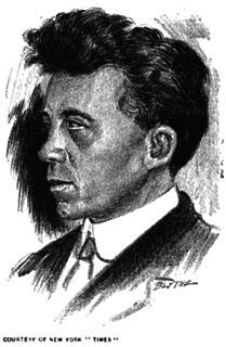
The Canadian Arctic Expedition 1913–1916 was a scientific expedition in the Arctic Circle organized and led by Vilhjalmur Stefansson. The expedition was originally to be sponsored by the (US) National Geographic Society and the American Museum of Natural History. Canada took over the sponsorship because of the potential for discovery of new land and Stefansson, who though born in Canada was now an American, re-established his Canadian citizenship. The expedition was divided into a Northern Party led by Stefansson, and a Southern Party led by R M. Anderson.
The Kilusiktogmiut were a Copper Inuit subgroup. They lived on Victoria Island, east of the Nagyuktogmiut who were known to inhabit the area northeast of Lady Franklin Point. They also lived on the mainland along the Coronation Gulf, particularly at the mouth of the Mackenzie River. They spent at least some time on the Banks Peninsula by Bathurst Inlet.
References
- ↑ "Aulavik National Park of Canada". pc.gc.ca. Retrieved 2008-11-08.
- 1 2 Stefansson, Vilhjalmur (1914). The Stefánsson-Anderson Arctic Expedition of the American Museum: Preliminary Ethnological Report. New York: The Trustees of the American Museum. pp. 26–31. OCLC 13626409.
| This article relating to the Indigenous peoples of North America is a stub. You can help Wikipedia by expanding it. |
| This Northwest Territories-related article is a stub. You can help Wikipedia by expanding it. |