
Duchesne County is a county in the northeast part of the U.S. state of Utah. As of the 2010 United States Census, the population was 18,607. Its county seat is Duchesne, and the largest city is Roosevelt.

Uintah County is a county in the U.S. state of Utah. As of the 2020 United States Census the population was 35,620. Its county seat and largest city is Vernal. The county was named for the portion of the Ute Indian tribe that lived in the basin.

Duchesne is a city in and the county seat of Duchesne County, Utah, United States. The population was 1,588 at the 2020 census.

Roosevelt is a city in Duchesne County, Utah, United States. The population was 6,046 at the 2010 census, with an estimated population of 7,070 in 2018.

Whiterocks is a census-designated place (CDP) in Uintah County, Utah, United States. The population was 341 at the 2000 census, a slight increase over the 1990 population of 312.

The San Juan River is a major tributary of the Colorado River in the Southwestern United States, providing the chief drainage for the Four Corners region of Colorado, New Mexico, Utah, and Arizona. Originating as snowmelt in the San Juan Mountains of Colorado, it flows 383 miles (616 km) through the deserts of northern New Mexico and southeastern Utah to join the Colorado River at Glen Canyon.

The Sevier River is a 400-mile (640 km)-long river in the Great Basin of southwestern Utah in the United States. Originating west of Bryce Canyon National Park, the river flows north through a chain of high farming valleys and steep canyons along the west side of the Sevier Plateau before turning southwest and terminating in the endorheic basin of Sevier Lake in the Sevier Desert. It is used extensively for irrigation along its course, with the consequence that Sevier Lake is usually dry.

Ute are the Indigenous people of the Ute tribe and culture among the Indigenous peoples of the Great Basin. They had lived in sovereignty in the regions of present-day Utah and Colorado in the Southwestern United States for many centuries until European settlers seized their lands. The state of Utah is named after the Ute tribe.

The Weber River is a c. 125-mile (201 km) long river of northern Utah, United States. It begins in the northwest of the Uinta Mountains and empties into the Great Salt Lake. The Weber River was named for American fur trapper John Henry Weber.
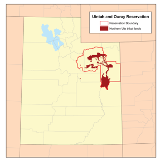
The Uintah and Ouray Indian Reservation is located in northeastern Utah, United States. It is the homeland of the Ute Indian Tribe, and is the largest of three Indian reservations inhabited by members of the Ute Tribe of Native Americans.
Fort Robidoux, also known as Fort Uintah and Fort Wintya, was a fur trading post at the junction of the Uinta River and Whiterocks River in the Uinta Basin of what is today Northeastern Utah. Fort Robidoux was founded in 1832 after Antoine Robidoux bought the Reed Trading Post that had been in operation there since 1828.

The Uinta Basin is a physiographic section of the larger Colorado Plateaus province, which in turn is part of the larger Intermontane Plateaus physiographic division. It is also a geologic structural basin in eastern Utah, east of the Wasatch Mountains and south of the Uinta Mountains. The Uinta Basin is fed by creeks and rivers flowing south from the Uinta Mountains. Many of the principal rivers flow into the Duchesne River which feeds the Green River—a tributary of the Colorado River. The Uinta Mountains forms the northern border of the Uinta Basin. They contain the highest point in Utah, Kings Peak, with a summit 13,528 feet above sea level. The climate of the Uinta Basin is semi-arid, with occasionally severe winter cold.

The Ute Indian Tribe of the Uinta and Ouray Reservation is a Federally Recognized Tribe of Indians in northeastern Utah, United States. Three bands of Utes comprise the Ute Indian Tribe: the Whiteriver Band, the Uncompahgre Band and the Uintah Band. The Tribe has a membership of more than three thousand individuals, with over half living on the Uintah and Ouray Indian Reservation. The Ute Indian Tribe operates its own tribal government and oversees approximately 1.3 million acres of trust land which contains significant oil and gas deposits.
The Central Utah Project is a US federal water project that was authorized for construction under the Colorado River Storage Project Act of April 11, 1956, as a participating project. In general, the Central Utah Project develops a portion of Utah's share of the yield of the Colorado River, as set out in the Colorado River Compact of 1922.
The Northern Ute Tribe is one of three ethnically-related Ute Tribes. The Northern Ute Tribe occupies and administers the Uintah and Ouray Indian Reservation in northeastern Utah. The population of the Northern Ute Tribe is approximately 3,500.
In Section 203(a) of the Central Utah Project Completion Act, the United States Congress authorized a federally authorized and funded replacement project to replace the Uinta and Upalco Units of the Central Utah Project (CUP) which were not constructed. The replacement project is the Uinta Basin Replacement Project (UBRP). The UBRP will provide: 2,500 acre-feet (3,100,000 m3) of irrigation water; 3,000 acre-feet (3,700,000 m3) of municipal and industrial water; reduced wilderness impacts; increased instream flows; and improved recreation. Design work began in 2002. Construction began in 2004 and is anticipated to be completed in 2011. The Central Utah Water Conservancy District is responsible for construction. The United States Department of the Interior oversees funding and compliance with law and environmental regulation.
The Timpanogos are a tribe of Native Americans who inhabited a large part of central Utah, in particular, the area from Utah Lake east to the Uinta Mountains and south into present-day Sanpete County.
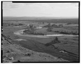
The Duchesne River, located in the Uintah Basin region of Utah in the western United States, is a tributary of the Green River. The watershed of the river covers the Northeastern corner of Utah. The Duchesne River is 115 miles (185 km) long, and drains a total land area of 3,790 square miles (9,800 km2).
Ouray is an unincorporated village of the Uintah and Ouray Indian Reservation, located in west‑central Uintah County, Utah, United States.
The Uinta Basin Rail project is a proposed 100-mile (160 km) rail line to connect the shale oil rich Uinta Basin region of eastern Utah to the national rail network. Numerous proposals have been made, some as far back as 1902, that are still under consideration. The current effort is a public-private partnership between a coalition of 7 counties in Utah, the Rio Grande Pacific Corporation and Drexel Hamilton Infrastructure Partners. The railroad is also backed by the Ute Tribe who hold a 5% stake in the project. If the rail line is built it will be the first major greenfield rail line built in the United States since the line to the Powder River Basin was built in the 1970s. The Surface Transportation Board approved construction of the line in December 2021.