
Uladail is a location near Amhuinnsuidhe, on Harris in the Outer Hebrides, Scotland.
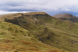
Sron Ulladail is a sheer cliff which at 370 metres (1,210 ft) is one of the highest in the British Isles.[ citation needed ] It stands over Loch Uladail. [1]
Uladail is a location near Amhuinnsuidhe, on Harris in the Outer Hebrides, Scotland.
Sron Ulladail is a sheer cliff which at 370 metres (1,210 ft) is one of the highest in the British Isles.[ citation needed ] It stands over Loch Uladail. [1]

Loch Katrine is a freshwater loch in the Trossachs area of the Scottish Highlands, east of Loch Lomond, within the historic county and registration county of Perthshire and the contemporary district of Stirling. The loch is about 8 miles (13 km) long and 1 mile (1.6 km) wide at its widest point, and runs the length of Strath Gartney. It is within the drainage basins of the River Teith and River Forth.
North Lochs,, an area in eastern Lewis, Outer Hebrides, Scotland, is named for the many lochans which dot the landscape. Because of its largely undulating and rocky terrain, it is sparsely populated apart from flat ground near the coast. Its communities support traditional crofting and fishing.

Park, also known as South Lochs, is a huge area of land connected to the rest of Lewis only by a narrow neck between Loch Seaforth and Loch Erisort. This had a wall called Gàrradh an Tighearna built across it by the Earl of Seaforth in the early 17th century, the outline of which can still be seen.

The Moine Thrust Belt or Moine Thrust Zone is a linear tectonic feature in the Scottish Highlands which runs from Loch Eriboll on the north coast 190 kilometres (120 mi) south-west to the Sleat peninsula on the Isle of Skye. The thrust belt consists of a series of thrust faults that branch off the Moine Thrust itself. Topographically, the belt marks a change from rugged, terraced mountains with steep sides sculptured from weathered igneous, sedimentary and metamorphic rocks in the west to an extensive landscape of rolling hills over a metamorphic rock base to the east. Mountains within the belt display complexly folded and faulted layers and the width of the main part of the zone varies up to 10 kilometres (6.2 mi), although it is significantly wider on Skye.

Stuchd an Lochain is a mountain in the Breadalbane region of the southern Scottish Highlands. It is a Munro, with a height of 960 metres (3,150 ft). It lies at the western end of Glen Lyon and forms the southern side of Loch an Daimh. The summit sits above a large corrie that contains a small lake called Lochan na Cat.
Meall Buidhe is a Munro situated in the southern highlands of Scotland. It forms the northern side of Loch an Daimh and is often climbed in conjunction with Stuchd an Lochain. The normal route climbs north from the eastern end of the loch until easier ground is reached. The route angles east and then north once the ridge is gained. Strong walkers can continue round the loch and take in a Corbett, Sron a' Choire Chnapanich, and the aforementioned Stuchd an Lochain.

Seaforth Island is an uninhabited island in the Outer Hebrides of Scotland. Unlike many other islands of the Outer Hebrides which are mainly surrounded by open sea, Seaforth Island lies in a narrow fjord-like sea loch named Loch Seaforth, 8 kilometres (5.0 mi) from the open waters of The Minch.

The Callanish IV stone circle is one of many megalithic structures around the better-known Calanais I on the west coast of the Isle of Lewis, in the Outer Hebrides, Scotland. It is a scheduled monument and its official name is Sron a'Chail. The site was first surveyed and recorded by RCAHMS in 1914 and again in 2009, with another survey in the 1970s by other archaeologists, but no known archaeological excavations have taken place at the stones.
Eilean Chaluim Chille is an unpopulated island in the Outer Hebrides.

Sròn a’ Choire Ghairbh is a Scottish mountain situated on the northern side of Loch Lochy, 13 kilometres north of Spean Bridge in the Highland Council area.

Meall na Teanga is a Scottish mountain located in the Highland council area, 11 km (7 mi) north of Spean Bridge.
Longa Island is a small uninhabited island at the mouth of Loch Gairloch, on the west coast of Scotland. Longa is nearly one mile in length with an area of 126 hectares and a maximum elevation of 70 metres (230 ft) above sea level.

Creise is a mountain summit in the Black Mount range, in the Scottish Highlands. It overlooks the northern end of Glen Etive and its height is 1,100 metres (3,600 ft). Creise is one of four Munros in the Black Mount, along with Meall a' Bhuiridh, Stob Ghabhar and Stob a' Choire Odhair. The mountain is a long and flattish ridge, whose highest point was unnamed until 1981. It is popular with cross-country skiers, being near the White Corries ski area from where it is often climbed along with adjoining Meall a' Bhuiridh. The steep and craggy northern buttress, Sròn na Crèise, is well seen from the A82 road road and the Kings House Hotel.

Amhuinnsuidhe is a settlement on Harris, in the Outer Hebrides, Scotland. The settlement is also within the parish of Harris. Amhuinnsuidhe is centred on the country house, Amhuinnsuidhe Castle, which is adjacent to the B887 road.

Ben Tee is a Scottish mountain situated in the Lochaber area of the Highland council area, some 15 kilometres north of Spean Bridge. It is rated as one of the best of Scotland's smaller mountains with Hamish Brown saying:
Ben Tee is such a shapely cone that it is instantly recognisable from anywhere around the Great Glen or along the Garry. Its isolated situation makes it one of Scotland’s finest summit viewpoints.
Madlamark is a neighborhood (delområde) in the city of Stavanger which lies in the southwestern part of the large municipality of Stavanger in Rogaland county, Norway. It is located in the borough of Madla at the innermost part of the Hafrsfjorden. This area was historically part of the municipality of Madla until 1965. The neighborhood has a population of 6,556 which is distributed over an area of 2.49 square kilometres. Madlamark Church is located in the centre of the neighborhood.

Glen Shira is a glen in Argyll, Scotland at the northern end of Loch Fyne, just to the north of Inveraray. It is a Special Area of Conservation within the UK, bordered by Beinn Bhuidhe on the Glen Fyne side.

River Shira is the river that runs for about 7 miles through Glen Shira, originating to the north-east at 350 metres (1,150 ft) altitude, near the start of the River Fyne.

The Hebridean Terrane is one of the terranes that form part of the Caledonian orogenic belt in northwest Scotland. Its boundary with the neighbouring Northern Highland Terrane is formed by the Moine Thrust Belt. The basement is formed by Archaean and Paleoproterozoic gneisses of the Lewisian complex, unconformably overlain by the Neoproterozoic Torridonian sediments, which in turn are unconformably overlain by a sequence of Cambro–Ordovician sediments. It formed part of the Laurentian foreland during the Caledonian continental collision.
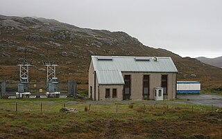
Chliostair Hydro-Electric Scheme was a small scheme promoted by the North of Scotland Hydro-Electric Board on Harris, Outer Hebrides. It consisted of a single power station powered with water from Loch Chliostair, and was commissioned in 1960.