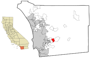
Harbison Canyon is a census-designated place (CDP) in San Diego County, California. Harbison Canyon had a population of 3,841 as of the 2010 census, up from 3,645 as of the 2000 census.

Tokoro is a district located in Okhotsk Subprefecture, Hokkaido, Japan.

Shibetsu is a district located in Nemuro Subprefecture, Hokkaido, Japan. As of 2004, its estimated population is 30,285 with a total area of 1309.44 km²

The Viana do Castelo District is a district located in the northwest of Portugal, bordered by Spain (Galicia) from the north and Braga District from the south. It has an area of 2,255 km2 and a population of 252,011 (2006), for a density of 111.8 inhabitants/km2. The district capital is the city of Viana do Castelo.

The Struve Geodetic Arc is a chain of survey triangulations stretching from Hammerfest in Norway to the Black Sea, through ten countries and over 2,820 km, which yielded the first accurate measurement of a meridian.

Kota Division is one of the administrative geographical unit, called a division, of Rajasthan state, India. The division comprises four districts, namely, Baran, Bundi, Jhalawar, Kota.
Bena was a railway station on the South Gippsland line in South Gippsland, Victoria, Australia. The station was opened during the 1890s, and closed to passenger and parcel traffic on 24 July 1978.
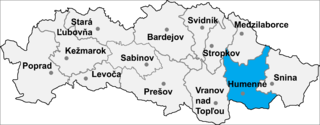
Závadka is a village and municipality in Humenné District in the Prešov Region of north-east Slovakia.

The Datem del Marañón is one of the eight provinces in the Loreto Region of Peru. It was created on August 2, 2005 during the presidency of Alejandro Toledo.

Betsiboka is a region of Madagascar. It borders Boeny Region in north, Sofia in northeast, Alaotra-Mangoro in east, Analamanga and Bongolava in south and Melaky in west. The capital of the region is Maevatanana. Until 2009 Betsiboka belonged to Mahajanga Province. The population was estimated to be 301,480 in 2014 within the area of 30,025 km2 (11,593 sq mi). Betsiboka is one of the least densely populated regions in Madagascar.

The Shire of Korumburra was a local government area located about 115 kilometres (71 mi) southeast of Melbourne, the state capital of Victoria, Australia. The shire covered an area of 613.8 square kilometres (237.0 sq mi), and existed from 1891 until 1994.

Łomnica is a village in the administrative district of Gmina Żelechów, within Garwolin County, Masovian Voivodeship, in east-central Poland. It lies approximately 5 kilometres (3 mi) north-west of Żelechów, 18 km (11 mi) south-east of Garwolin, and 73 km (45 mi) south-east of Warsaw.
Czaplice-Bąki is a village in the administrative district of Gmina Krzynowłoga Mała, within Przasnysz County, Masovian Voivodeship, in east-central Poland.
Żydowo is a village in the administrative district of Gmina Bartoszyce, within Bartoszyce County, Warmian-Masurian Voivodeship, in northern Poland, close to the border with the Kaliningrad Oblast of Russia. It lies approximately 8 kilometres (5 mi) north of Bartoszyce and 63 km (39 mi) north of the regional capital Olsztyn.
Parleza Mała is a village in the administrative district of Gmina Biskupiec, within Olsztyn County, Warmian-Masurian Voivodeship, in northern Poland.
Białe is a settlement in the administrative district of Gmina Szczecinek, within Szczecinek County, West Pomeranian Voivodeship, in north-western Poland. It lies approximately 13 kilometres (8 mi) north of Szczecinek and 144 km (89 mi) east of the regional capital Szczecin.

Yingzhou District is a district of the city of Fuyang, Anhui Province, China.
Richmond Park was a railway station of the Glen Iris line in Melbourne, Australia. The station was situated between Burnley railway station and Heyington railway station. The station was opened in March 1890, but was closed just two months later in May 1890. The station was located in Richmond Park.

Qarah Benas is a village in Khezel-e Gharbi Rural District, in the Central District of Kangavar County, Kermanshah Province, Iran. At the 2006 census, its population was 292, in 65 families.
Sud Kola is a village in Banaft Rural District, Dodangeh District, Sari County, Mazandaran Province, Iran. At the 2006 census, its population was 132, in 41 families.


