
Kansas City, Missouri is the largest city in the U.S. state of Missouri by population and area. Most of the city lies within Jackson County, with portions spilling into Clay, Platte, and Cass counties. It is the central city of the Kansas City metropolitan area, which straddles the Missouri–Kansas state line and has a population of 2,392,035. As of the 2020 census, the city had a population of 508,090, making it the 37th most-populous city in the United States, as well as the sixth-most populous city in the Midwest. Kansas City was founded in the 1830s as a port on the Missouri River at its confluence with the Kansas River from the west. On June 1, 1850, the town of Kansas was incorporated; shortly after came the establishment of the Kansas Territory. Confusion between the two ensued, and the name Kansas City was assigned to distinguish them soon after.

Interstate 70 (I-70) is a major east–west Interstate Highway in the United States that runs from I-15 near Cove Fort, Utah, to I-695 and Maryland Route 570 (MD 570) in Woodlawn, just outside Baltimore, Maryland. I-70 approximately traces the path of U.S. Route 40 east of the Rocky Mountains. West of the Rocky Mountains, the route of I-70 was derived from multiple sources. The Interstate runs through or near many major cities, including Denver, Topeka, Kansas City, St. Louis, Indianapolis, Columbus, Pittsburgh, and Baltimore. The sections of the Interstate in Missouri and Kansas have laid claim to be the first Interstate in the United States. The Federal Highway Administration (FHWA) has claimed the section of I-70 through Glenwood Canyon in Colorado, completed in 1992, to be the last piece of the Interstate Highway System, as originally planned, to open to traffic. The construction of I-70 in Colorado and Utah is considered an engineering marvel, as the route passes through the Eisenhower Tunnel, Glenwood Canyon, and the San Rafael Swell. The Eisenhower Tunnel is the highest point along the Interstate Highway System, with an elevation of 11,158 feet (3,401 m).

North Kansas City is a city in Clay County, Missouri, United States. It is also enclaved in Kansas City. Even though the name is similar to its larger counterpart, Kansas City, it is an independent municipality and part of the Kansas City metropolitan area. The population was 4,467 at the 2020 census. Originally a northern suburb across the Missouri River from Kansas City, it is now almost completely surrounded by Kansas City, which has annexed far to the north of North Kansas City's northern city limits. North Kansas City also adjoins the small municipality of Avondale.

The Kansas River, also known as the Kaw, is a meandering river river in northeastern Kansas in the United States. It is potentially the southwestern most part of the Missouri River drainage, which is sometimes in turn the northwesternmost portion of the extensive Mississippi River drainage. Its two names both come from the Kanza (Kaw) people who once inhabited the area; Kansas was one of the anglicizations of the French transcription Cansez of the original kką:ze. The city of Kansas City, Missouri, was named for the river, as was later the state of Kansas.

The Republican River is a river in the central Great Plains of North America, rising in the High Plains of eastern Colorado and flowing east 453 miles (729 km) through the U.S. states of Nebraska and Kansas.

U.S. Route 40 or U.S. Highway 40 (US 40), also known as the Main Street of America, is a major east–west United States Highway traveling across the United States from the Mountain States to the Mid-Atlantic States. As with most routes whose numbers end in a zero, US 40 once traversed the entire United States. It is one of the first U.S. Highways created in 1926 and its original termini were in San Francisco, California, and Atlantic City, New Jersey. US 40 currently ends at a junction with I-80 in Silver Summit, Utah, just outside Salt Lake City. West of this point US 40 was functionally replaced with I-80, and as these segments of I-80 were constructed the western portion of US 40 was truncated several times.

The Katy Trail State Park is a state park in the U.S. state of Missouri that contains the Katy Trail, the country's longest continuous recreational rail trail. It runs 240 miles (390 km), largely along the northern bank of the Missouri River, in the right-of-way of the former Missouri–Kansas–Texas Railroad. Open year-round from sunrise to sunset, it serves hikers, joggers, and cyclists. Its hard, flat surface is of "limestone pug".

The Kansas Turnpike is a 236-mile (380 km) controlled-access toll road that lies entirely within the US state of Kansas. It runs in a general southwest–northeast direction from the Oklahoma border to Kansas City. It passes through several major Kansas cities, including Wichita, Topeka, and Lawrence. The turnpike is owned and maintained by the Kansas Turnpike Authority (KTA), which is headquartered in Wichita.

U.S. Route 24 or U.S. Highway 24 (US 24) is one of the original United States Numbered Highways of 1926. It originally ran from Pontiac, Michigan, in the east to Kansas City, Missouri, in the west. Today, the highway's eastern terminus is in Independence Township, Michigan, at an intersection with Interstate 75 (I-75), and its western terminus is near Minturn, Colorado, at an intersection with I-70. The highway transitions from north–south to east–west signage at the Ohio–Michigan state line.

U.S. Highway 159 (US 159) is a 83.6-mile-long (134.5 km) auxiliary route of US 59. It travels from Nortonville, Kansas at US 59 to New Point, Missouri, also at US 59. The highway permits through traffic on US 59 to bypass the cities of Atchison, Kansas and Saint Joseph, Missouri, traveling instead through Falls City, Nebraska and Hiawatha, Kansas.
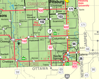
Riverton is an unincorporated community in Cherokee County, Kansas, United States. As of the 2020 census, the population of the community and nearby areas was 771. It is located at the junction of K-66 and U.S. Route 69 Alternate and U.S. Route 400, near the Spring River. It is one of only three communities in Kansas along former U.S. Route 66.

Interstate 635 (I-635) is a connector highway between I-35 in Overland Park, Kansas, and I-29 in Kansas City, Missouri, approximately 12 miles (19 km) long. It is mostly in the US state of Kansas, servicing the city of Kansas City, Kansas, but extends into Kansas City, Missouri, as well. The freeway's southern terminus is at a stack interchange with I-35. South of this, the mainline becomes an expressway carrying U.S. Route 69 (US 69).
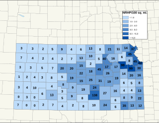
There are over 1,600 buildings, sites, districts, and objects in Kansas listed on the National Register of Historic Places in Kansas. NRHP listings appear in 101 of the state's 105 counties.
The Kansas, Oklahoma and Gulf Railway (“KO&G”) had at its height 310.5 miles of track from Denison, Texas through Oklahoma to Baxter Springs, Kansas. Its various predecessor companies built the line between 1904 and 1913. The railroad was consolidated into a Missouri Pacific Railroad subsidiary—the Texas and Pacific Railway—in 1963.

Forgottonia, also spelled Forgotonia, is the name given to a 16-county region in Western Illinois in the late 1960s and early 1970s. This geographic region forms the distinctive western bulge of Illinois that is roughly equivalent to "The Tract", the Illinois portion of the Military Tract of 1812, along and west of the Fourth Principal Meridian. Since this wedge-shaped region lies between the Illinois and Mississippi rivers, it has historically been isolated from the eastern portion of Central Illinois.

The Hannibal and St. Joseph Railroad was the first railroad to cross Missouri starting in Hannibal in the northeast and going to St. Joseph, Missouri, in the northwest. It is said to have carried the first letter to the Pony Express on April 3, 1860, from a train pulled behind the locomotive Missouri.

The First Hannibal Bridge was the first permanent rail crossing of the Missouri River and helped establish the City of Kansas as a major city and rail center. In its early days it was called the Kansas City Bridge. It increased area train traffic, which contributed to the building of Union Depot, the predecessor to the Kansas City Union Station. It was severely damaged by a tornado and replaced in virtually the same location by the Second Hannibal Bridge.
Francis Reid Long was Kansas City Mayor in 1869 and founder of what would become Commerce Bancshares.

The Missouri Valley Bridge & Iron Co., also known as Missouri Valley Bridge Company, was a engineering, construction, and steel fabrication firm that operated through the late nineteenth and most of the twentieth centuries. It was based in Leavenworth, Kansas, with a WWII facility in Evansville, Indiana.

The 2011 flooding event on the Missouri River in the United States was triggered by record snowfall in Rocky Mountains of Montana and Wyoming along with near-record spring rainfall in central and eastern Montana. All six major dams along the Missouri River released record amounts of water to prevent overflow which led to flooding threatening several towns and cities along the river from Montana to Missouri; in particular Bismarck, North Dakota; Pierre, South Dakota; Dakota Dunes, South Dakota; South Sioux City, Nebraska, Sioux City, Iowa; Omaha, Nebraska; Council Bluffs, Iowa; Saint Joseph, Missouri; Kansas City, Missouri; Jefferson City, Missouri, and St. Louis, Missouri. Many smaller towns were also at risk, suffering the same fate as the larger cities if not worse. According to the National Weather Service, in the second half of the month of May 2011, almost a year's worth of rain fell over the upper Missouri River basin. Extremely heavy rainfall in conjunction with an estimated 212 percent of normal snowpack in the Rocky Mountains contributed to this flooding event.
