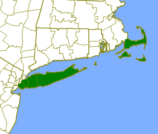
United States v. Maine, 469 U.S. 504 (1985), also known as the Rhode Island and New York Boundary Case, was a decision by the U.S. Supreme Court, which held that Long Island Sound and Block Island Sound in part constitute a juridical bay under Article 7(6) of the Convention on the Territorial Sea and the Contiguous Zone, Long Island being an extension of the mainland and the southern headland of the bay, and (b) that the bay closed at the line drawn from Montauk Point at the eastern tip of Long Island to Watch Hill Point on the Rhode Island shore, the waters of the bay west of the closing line being internal state waters, and the waters of Block Island Sound east of that line being territorial waters and high seas. Maine is named in the title of the case because it is the northernmost of the thirteen defendant states with coastline on the Atlantic Ocean in a series of cases related to overlapping claims of state and federal jurisdiction over seas and the seafloor.
The federal government and the states did not agree on who controlled the Long Island and Block Island sounds. The states wanted control to regulate shipping and commerce on the sounds. The key to the case was if Long Island was, for legal purposes, an extension of the mainland or by the Convention an island. If it were considered an extension of the mainland, as the states argued, then the sounds would legally be inland bays controlled in relevant parts by the states, New York, Connecticut, or Rhode Island. If it were, for the Convention's purposes, an island, then the sounds would be considered open waters and be under federal control.
The court ruled in favor of the states, determining that the East River, which separates Long Island from the mainland at the Bronx, was too small for modern navigation until humans altered it. Thus, it was decided that Long Island is not a natural island under the law. Long Island and the adjacent shore also share a common geological history.
Article Four of the United States Constitution outlines the relationship between the various states, as well as the relationship between each state and the United States federal government. It also empowers Congress to admit new states and administer the territories and other federal lands.
Admiralty law or maritime law is a body of law that governs nautical issues and private maritime disputes. Admiralty law consists of both domestic law on maritime activities, and private international law governing the relationships between private parties operating or using ocean-going ships. While each legal jurisdiction usually has its own legislation governing maritime matters, the international nature of the topic and the need for uniformity has, since 1900, led to considerable international maritime law developments, including numerous multilateral treaties.
Long Island Sound is a marine sound and tidal estuary of the Atlantic Ocean. It lies predominantly between the U.S. state of Connecticut to the north and Long Island in New York to the south. From west to east, the sound stretches 110 mi (180 km) from the East River and the Throgs Neck Bridge in New York City, along the North Shore of Long Island, to Block Island Sound. A mix of freshwater from tributaries, and saltwater from the Atlantic Ocean, Long Island Sound is 21 mi (34 km) at its widest point and varies in depth from 65 to 230 feet.
In the United States, a territory is any extent of region under the sovereign jurisdiction of the federal government of the United States, including all waters. The United States asserts sovereign rights for exploring, exploiting, conserving, and managing its territory. This extent of territory is all the area belonging to, and under the dominion of, the United States federal government for administrative and other purposes. The United States total territory includes a subset of political divisions.
Territorial waters are informally an area of water where a sovereign state has jurisdiction, including internal waters, the territorial sea, the contiguous zone, the exclusive economic zone, and potentially the extended continental shelf. In a narrower sense, the term is often used as a synonym for the territorial sea.
The Strait of Georgia or the Georgia Strait is an arm of the Salish Sea between Vancouver Island and the extreme southwestern mainland coast of British Columbia, Canada, and the extreme northwestern mainland coast of Washington, United States. It is approximately 240 kilometres (150 mi) long and varies in width from 20 to 58 kilometres. Along with the Strait of Juan de Fuca and Puget Sound, it is a constituent part of the Salish Sea.
Machias Seal Island is an island in disputed water between the Gulf of Maine and the Bay of Fundy, about 16 km (10 mi) southeast from Cutler, Maine, and 19 km (12 mi) southwest of Grand Manan Island, New Brunswick. Sovereignty of the island is disputed by the United States and Canada. The Canadian Coast Guard continues to staff a lighthouse on the island; the first lighthouse was constructed there in 1832.
Passamaquoddy Bay is an inlet of the Bay of Fundy, between the U.S. state of Maine and the Canadian province of New Brunswick, at the mouth of the St. Croix River. Most of the bay lies within Canada, with its western shore bounded by Washington County, Maine. The southernmost point is formed by West Quoddy Head on the U.S. mainland in Lubec, Maine; and runs northeasterly through Campobello Island, New Brunswick, engulfing Deer Island, New Brunswick, to the New Brunswick mainland head at L'Etete, New Brunswick in Charlotte County, New Brunswick.
An exclusive economic zone (EEZ), as prescribed by the 1982 United Nations Convention on the Law of the Sea, is an area of the sea in which a sovereign state has exclusive rights regarding the exploration and use of marine resources, including energy production from water and wind.
The United States territorial courts are tribunals established in territories of the United States by the United States Congress, pursuant to its power under Article Four of the United States Constitution, the Territorial Clause. Most United States territorial courts are defunct because the territories under their jurisdiction have become states or been retroceded.
A bay is a recessed, coastal body of water that directly connects to a larger main body of water, such as an ocean, a lake, or another bay. A large bay is usually called a gulf, sea, sound, or bight. A cove is a small, circular bay with a narrow entrance. A fjord is an elongated bay formed by glacial action. The term embayment is also used for related features, such as extinct bays or freshwater environments.
The states and territories are the second level of government of Australia. The states are administrative divisions that are self-governing polities that are partly sovereign, having ceded some sovereign rights to the federal government. They have their own constitutions, legislatures, executive governments, judiciaries and law enforcement agencies that administer and deliver public policies and programs. Territories can be autonomous and administer local policies and programs much like the states in practice, but are still legally subordinate to the federal government.
An enclave is a territory that is entirely surrounded by the territory of only one other state or entity. Such territory can be a small territory as part of a larger one. Enclaves may also exist within territorial waters. Enclave is sometimes used improperly to denote a territory that is only partly surrounded by another state. Many enclaves are also exclaves, but some are not, for example Vatican City and San Marino and Lesotho are completely enclaved sovereign states.
The Outer Lands is the prominent terminal moraine archipelagic region off the southern coast of New England in the United States. This eight-county region of Massachusetts, Rhode Island, and New York comprises the peninsula of Cape Cod and the islands of Nantucket, Martha's Vineyard, the Elizabeth Islands, Block Island, and Long Island, as well as surrounding islands and islets.
Ambalat is a sea block in the Celebes sea located off the east coast of Borneo. It lies to the east of the Indonesian province of North Kalimantan and to the south-east of the Malaysian state of Sabah, and it is the subject of a territorial dispute between the two nations. Malaysia refers to part of the Ambalat block as Block ND6 (formerly Block Y) and part of East Ambalat Block as Block ND7 (formerly Block Z). The deep sea blocks contain an estimated 62,000,000 barrels (9,900,000 m3) of oil and 348 million cubic meters of natural gas. Other estimates place it substantially higher: 764,000,000 barrels (121,500,000 m3) of oil and 3.96 × 10¹⁰ cubic meters (1.4 trillion cubic feet) of gas, in only one of nine points in Ambalat.
Border irregularities of the United States, particularly panhandles and highway incursions into other jurisdictions, are shown here. Often they are a result of borders which do not conform to geological features such as changes in the course of a river that previously marked a border.
The United States has land borders with only Canada and Mexico, both of them long. It has maritime boundaries with many countries due to its extensive exclusive economic zone (EEZ). All of its maritime borders with Canada are at least partially disputed, and its territorial claims on three Caribbean islands are disputed.
The Indonesia–Malaysia border consists of a 1,881 km land border that divides the territory of Indonesia and Malaysia on the island of Borneo. It also includes maritime boundaries along the length of the Straits of Malacca, in the South China Sea and in the Celebes Sea.
Tidelands are the territory between the tide line of sea coasts, and lands lying under the sea beyond the low-water limit of the tide, considered within the territorial waters of a nation. The United States Constitution does not specify whether ownership of these lands rests with the federal government or with individual states. Originally little commercial value was attached to tidelands, so ownership was never firmly established, but the coastal states generally proceeded as if they were the owners. Some states, such as Mississippi, directly administer these lands under the public trust doctrine.
This page is based on this Wikipedia article Text is available under the CC BY-SA 4.0 license; additional terms may apply. Images, videos and audio are available under their respective licenses.