
The Unteraargau is the lower watershed of the Aar River in the Swiss canton of Aargau.
The Unteraargau is the lower watershed of the Aar River in the Swiss canton of Aargau.
It corresponds approximately to the canton's southwestern districts of Aarau, Brugg, Kulm, Lenzburg and Zofingen. The Unteraargau includes that portion of the Aar valley between Aarau and the Klingnauer Stausee, as well as the Aar tributary valleys of the Aabach, Suhre, Wigger and Wyna rivers. It also includes some parts of the Jura Mountains.
The region was held by the Swabian counts of Lenzburg and Kyburg, in 1264 it fell to the House of Habsburg. It is sometimes called the Berner Aargau, with reference to its incorporation into the territory of Bern from 1415 to 1798. Until 1415, the region belonged to the Further Austrian possessions of Archduke Frederick IV of Habsburg. When he was outlawed by Emperor Sigismund of Luxembourg, his territories were forfeit. His former subjects agreed to acquire the land, and the Bernese citizens of the Swiss Confederacy were the first on the ground.
The area was then consolidated with the Oberaargau into one region after the conquest by the city of Bern. When Bern lost its old power with the invasion by French troops after the French Revolution in 1798, the Unteraargau became the modern canton of Aargau. The boundary between the Oberaargau and Unteraargau was fixed in 1798 along the Wigger River. In 1802, however, it was shifted west to the river Murg. This action was confirmed by the Act of Mediation of Napoleon in 1803 and the Congress of Vienna in 1815.

Aarau is a town, a municipality, and the capital of the northern Swiss canton of Aargau. The town is also the capital of the district of Aarau. It is German-speaking and predominantly Protestant. Aarau is situated on the Swiss plateau, in the valley of the Aare, on the river's right bank, and at the southern foot of the Jura Mountains, and is west of Zürich, 58 kilometres (36 mi) south of Basel and 65 kilometres (40 mi) northeast of Bern. The municipality borders directly on the canton of Solothurn to the west. It is the largest town in Aargau. At the beginning of 2010 Rohr became a district of Aarau.

Aargau, more formally the Canton of Aargau, is one of the 26 cantons forming the Swiss Confederation. It is composed of eleven districts and its capital is Aarau.

The canton of Bern, or Berne, is one of the 26 cantons forming the Swiss Confederation. Its capital city, Bern, is also the de facto capital of Switzerland. The bear is the heraldic symbol of the canton, displayed on a red-yellow background.

Lenzburg is a town in the central region of the Swiss canton Aargau and is the capital of the Lenzburg District. The town, founded in the Middle Ages, lies in the Seetal valley, about 3 kilometres south of the Aare river. Lenzburg and the neighbouring municipalities of Niederlenz and Staufen have grown together in an agglomeration.

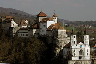
Lenzburg Castle is a castle located above the old part of the town of Lenzburg in the Canton of Aargau, Switzerland. It ranks among the oldest and most important of Switzerland. The castle stands on the almost circular castle hill, which rises approximately 100 m (330 ft) over the surrounding plain but is only about 250 m (820 ft) in diameter. The oldest parts of the castle date to the 11th century, when the Counts of Lenzburg built it as their seat. The castle, its historical museum and the castle hill with its Neolithic burial grounds are listed as heritage sites of national significance.

Biberstein is a municipality in the district of Aarau of the canton of Aargau in Switzerland.
The Fricktal is a region on Northwestern Switzerland, comprising the Laufenburg and Rheinfelden districts of the Swiss canton of Aargau. The region was known as Frickgau in the medieval period, ultimately from a Late Latin [regio] ferraricia, in reference to the iron mine located here in the Roman era, also transferred to the village of Frick as the main settlement.
Salhöhe Pass is a mountain pass in the Jura Mountains of Switzerland between Kienberg in the canton of Solothurn and Erlinsbach in the canton of Aargau.
The County of Baden was a condominium of the Old Swiss Confederacy and is now part of the Swiss canton of Aargau. The county was established in 1415 after the Swiss conquest of the Aargau and was ruled as a shared condominium until 1798 when it became part of the short-lived Canton of Baden.

The Freiamt or Freie Ämter is a region in Switzerland and is located in the southeast of Canton of Aargau. It comprises the area between the Lindenberg and Heitersberg and from the terminal moraine at Othmarsingen to Reuss river in Dietwil. Today the area of the Bremgarten and Muri Districts are called the Freiamt. Previously, the area around Affoltern District in the canton of Zurich was called the (Zurich) Freiamt.
The Oberaargau is the region that encompasses the upper watershed of the Aar River in the canton of Bern in Switzerland. On the north, lie the Jura Mountains, and on the south the hills leading to the Emmental.
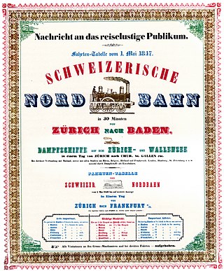
The Swiss Northern Railway , informally known as the Spanisch-Brötli-Bahn, opened the first railway line within Switzerland in 1847, the Zürich–Baden line. This followed the extension of a French railway to Basel in 1844. The original line generally followed the south bank of the Limmat from Zürich to near its confluence with the Aar near Brugg and then it generally followed the south bank of the Aar to Olten. It was absorbed into the Swiss Northeastern Railway in 1853 and extended from Baden to Brugg in 1858. The line was absorbed into the Swiss Federal Railways on its establishment in 1902. It is electrified at 15 kV 16.7 Hz and its eastern 16 km section from Zürich to Killwangen-Spreitenbach is now part of the Zürich–Olten trunkline and has four tracks.
The Kyburg family was a noble family of grafen (counts) in the Duchy of Swabia, a cadet line of the counts of Dillingen, who in the late 12th and early 13th centuries ruled the County of Kyburg, corresponding to much of what is now Northeastern Switzerland.

Schenkenberg Castle is a castle ruin above the municipality of Thalheim in the canton of Aargau in Switzerland. It was built in the 13th Century by the Habsburg dynasty, was the administrative seat for 260 years of a bailiwick of the city of Bern and fell into ruin in the 18th century.

Brunegg castle is a castle in the municipality of Brunegg in the canton of Aargau in Switzerland.
Aarburg Castle is a castle in the municipality of Aarburg in the canton of Aargau in Switzerland. It is located high above the town Aarburg on a steep, rocky hillside. The castle was built around a medieval castle, which controlled the narrow point on the Aare river and served as the seat of Aarburg Vogt. It is classified as a Swiss heritage site of national significance. Today it houses the Kantonale Jugendheim, for holding and rehabilitating juvenile offenders.

Liebegg Castle is a small castle in the municipality of Gränichen in the canton of Aargau in Switzerland. It is located on a outcropping about 70 meters (230 ft) above the Wynental valley floor. The current castle grew out of a medieval castle. A cantonal agricultural school opened in 1958 near the castle.

Trostburg Castle is a small castle in the municipality of Teufenthal in the canton of Aargau in Switzerland.
Auenstein Castle is a castle in the municipality of Auenstein in the Swiss canton of Aargau.
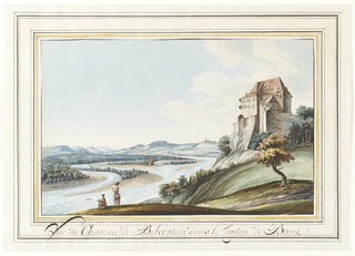
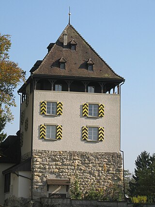
Biberstein Castle is a castle in the municipality of Biberstein in the Swiss canton of Aargau.