
Uonukuhihifo is an islet which belongs to Uonukuhahake island, Tonga. It is located within the Ha'apai Group.


Uonukuhihifo is an islet which belongs to Uonukuhahake island, Tonga. It is located within the Ha'apai Group.

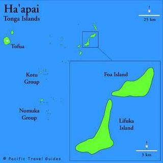
Haʻapai is a group of islands, islets, reefs, and shoals in the central part of Tonga. It has a combined land area of 109.30 square kilometres (42.20 sq mi). The Tongatapu island group lies to its south, and the Vavaʻu group lies to its north. Seventeen of the Haʻapai islands are inhabited. Their combined population is 5,419. The highest point in the Ha‘apai group, and in all of Tonga, is on Kao, which rises almost 1,050 metres (3,440 ft) above sea level.

Haʻafeva is a small island in the Haʻapai group of Tonga, but still the main island of the Lulunga archipelago. Kolongatata is the name commonly given to the village on Haʻafeva and is a reference to Haʻafeva's exposure to strong winds. The inhabited area of Haʻafeva can be divided into Hahake, Hihifo, Tuʻa Kolo, Loto Kolo and Uta. The Island has a population of 192.

Nomuka is a small island in the southern part of the Haʻapai group of islands in Tonga. It is part of the Nomuka Group of islands, also called the ʻOtu Muʻomuʻa. Among neighboring islands are Kelefesia, Nukutula, Tonumea, Fonoifua, Telekitonga.

Metis Shoal, also known as Lateiki Island, is a volcanic island at the top of a submarine volcano in Tonga, located between the islands of Kao and Late. The current island formed in October 2019, when a smaller island disappeared after 24 years.
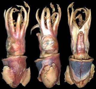
Choneteuthis tongaensis is a species of bobtail squid native to the waters around the Tonga Islands in the southern Pacific Ocean. It is known from only three specimens. Of these, the holotype is the largest, at 33.8 mm mantle length (ML). C. tongaensis is characterised by several distinct morphological features: the mantle is free from the head in the nuchal region, a large, circular visceral photophore and ventral shield are present on the ventral surface of the ink sac, and the broad keel extends the full length of the club.
Foa is an island in Tonga. It is located within the Haʻapai group in the centre of the country, to northeast of the national capital of Nukuʻalofa.
Hakauata is an island in Tonga. It is located within the Ha'apai Group in the center of the country, to northeast of the national capital of Nukuʻalofa.

Lifuka is an island in the Kingdom of Tonga. It is located within the Haʻapai Group in the centre of the country, to northeast of the national capital of Nukuʻalofa.
Lofanga is an island in Tonga. It is located within the Ha'apai Group in the centre of the country, to northeast of the national capital of Nukuʻalofa. The island had a population of 137 at 2016, and an area of 1.45 km2.

Luangahu is an island in Tonga. It is located within the Ha'apai Group in the centre of the country, to northeast of the national capital of Nukuʻalofa. The island is used as a fishing ground by the villagers of Lofanga.
Tokū is an uninhabited, volcanic island in Tonga. It is located in the very north of Vavaʻu group in the north of the country. It is about 1,000 metres long and up to 700 metres wide, yielding an area of 0.4 square kilometres. It is up to 8 metres above sea level near its east coast.

Haʻano is an island in the Haʻapai islands of Tonga. To the south are the islands of Foa and Lifuka.

Uonukuhahake is an island in Lifuka district, in the Ha'apai islands of Tonga.
ʻUiha is an island in Lifuka district, in the Haʻapai islands of Tonga. It had a population of 638 in 2006 and an area of 5.36 km2 (2.07 sq mi). The island has two villages, ʻUiha and Felemea.
Fetoa is an island in Lulunga district, in the Ha'apai group of islands of Tonga. The island is rocky, about 125 feet high, and separated from neighbouring Haafeva by a deep channel.
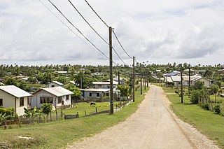
Pangai is the administrative capital village of the Haʻapai Group in Tonga.
Tatafa is an islet which belongs to ʻUiha island, Tonga. It is located within the Ha'apai Group.
Tofanga is an islet which belongs to Uonukuhahake island, Tonga. It is located within the Ha'apai Group.
Mango is a small island in Tonga, 9 kilometres south-east of the larger island of Nomuka, and part of the Nomuka or ʻOtu Muʻomuʻa group of islands, which are the southern part of the Haʻapai group. Mango had a population of 62 in the 2021 census.
19°58′08″S174°29′42″W / 19.969°S 174.495°W
| | This Tongan location article is a stub. You can help Wikipedia by expanding it. |