Urbainville, Prince Edward Island

Last updated

Urbainville is a community in the Canadian province of Prince Edward Island, located in Lot 16 of Prince County, northwest of Summerside.

Canada Country in North America

Canada is a country in the northern part of North America. Its ten provinces and three territories extend from the Atlantic to the Pacific and northward into the Arctic Ocean, covering 9.98 million square kilometres, making it the world's second-largest country by total area. Canada's southern border with the United States is the world's longest bi-national land border. Its capital is Ottawa, and its three largest metropolitan areas are Toronto, Montreal, and Vancouver. As a whole, Canada is sparsely populated, the majority of its land area being dominated by forest and tundra. Consequently, its population is highly urbanized, with over 80 percent of its inhabitants concentrated in large and medium-sized cities, many near the southern border. Canada's climate varies widely across its vast area, ranging from arctic weather in the north, to hot summers in the southern regions, with four distinct seasons.

Prince Edward Island Province of Canada

Prince Edward Island is a province of Canada consisting of the Atlantic island of the same name along with several much smaller islands nearby. PEI is one of the three Maritime Provinces. It is the smallest province of Canada in both land area and population, but it is the most densely populated. Part of the traditional lands of the Mi'kmaq, it became a British colony in the 1700s and was federated into Canada as a province in 1873. Its capital is Charlottetown. According to the 2016 census, the province of PEI has 142,907 residents.

Lot 16, Prince Edward Island Township in Prince Edward Island, Canada

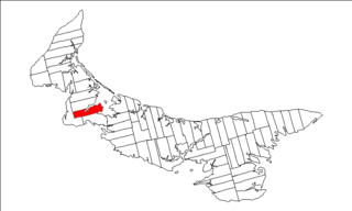
Lot 16 is a township in Prince County, Prince Edward Island, Canada. It is part of Richmond Parish.

Coordinates: 46°27′47″N64°02′17″W / 46.463°N 64.038°W / 46.463; -64.038

Geographic coordinate system Coordinate system

A geographic coordinate system is a coordinate system that enables every location on Earth to be specified by a set of numbers, letters or symbols. The coordinates are often chosen such that one of the numbers represents a vertical position and two or three of the numbers represent a horizontal position; alternatively, a geographic position may be expressed in a combined three-dimensional Cartesian vector. A common choice of coordinates is latitude, longitude and elevation. To specify a location on a plane requires a map projection.

Related Research Articles

Knutsford, Prince Edward Island human settlement in Prince County, Prince Edward Island, Canada

Knutsford is an unincorporated rural community in Prince County, Prince Edward Island.

Foxley River, Prince Edward Island settlement in Lot 11 and Area, Prince Edward Island

Foxley River is a Canadian rural community in Prince County, Prince Edward Island.

North Parish, Prince Edward Island

North Parish was created as a civil parish in Prince County, Prince Edward Island, Canada, during the 1764-1766 survey of Samuel Holland.

Egmont Parish, Prince Edward Island

Egmont Parish was created as a civil parish in Prince County, Prince Edward Island, Canada, during the 1764-1766 survey of Samuel Holland.

Halifax Parish, Prince Edward Island

Halifax Parish was created as a civil parish in Prince County, Prince Edward Island, Canada, during the 1764-1766 survey of Samuel Holland.

St. Felix is a municipality that holds community status in Prince Edward Island, Canada. It is located in Prince County, 4 km (2.5 mi) south of Tignish.

Cedar Dunes Provincial Park provincial park in Prince Edward Island, Canada

Cedar Dunes Provincial Park is a provincial park in Prince Edward Island, Canada.

Jacques Cartier Provincial Park

Jacques Cartier Provincial Park is a provincial park in Prince Edward Island, Canada.

Mill River Provincial Park is a provincial park in Prince Edward Island, Canada.

Bloomfield Provincial Park

Bloomfield Provincial Park is a provincial park in Prince Edward Island, Canada.

Prince County, Prince Edward Island Place

Prince County is located in western Prince Edward Island, Canada. The county's defining geographic feature is Malpeque Bay, a sub-basin of the Gulf of St. Lawrence, which creates the narrowest portion of Prince Edward Island's landmass, an isthmus upon which the city of Summerside is located.

OLeary, Prince Edward Island Town in Prince Edward Island, Canada

O'Leary is a town located in Prince County, Prince Edward Island.

Miminegash, Prince Edward Island human settlement in Prince Edward Island, Canada

Miminegash is a municipality that holds community status in Prince Edward Island, Canada. It is located 8 miles (13 km) northwest of Alberton and 11 miles (18 km) southwest of Tignish. It is part of a small area known as either the St. Louis, Palmer Road, or Miminegash area. This area is often associated with Tignish due to the shared Acadian roots between these areas.

Wellington, Prince Edward Island rural municipality in Prince Edward Island

Wellington is a municipality that holds community status in Prince Edward Island, Canada. It is located in Prince County, and extends as Wellington Centre onto Route 2 from Richmond through to St. Nicholas.

Abram-Village is a Canadian rural municipality located in Prince County, Prince Edward Island.

OLeary-Inverness Provincial electoral district in Prince Edward Island

O'Leary-Inverness is a provincial electoral district for the Legislative Assembly of Prince Edward Island, Canada. It was formerly known as West Point-Bloomfield from 1996 to 2007. It was created in 1996 from parts of 1st Prince and 2nd Prince. It is notable for being the first district on the Island to ever elect a member of a third party to the legislature.

Tignish-Palmer Road Provincial electoral district in Prince Edward Island

Tignish-Palmer Road is a provincial electoral district for the Legislative Assembly of Prince Edward Island, Canada. It was formerly Tignish-DeBlois from 1996 to 2007.

Pululagua is a dormant volcano in the north of Quito Canton, Pichincha Province, Ecuador. The volcano is in the Western Cordillera of the northern Ecuadorian Andes, approximately west-southwest of Mojanda and north of Casitahua volcanoes. Pululagua's caldera is approximately 5 km wide.

Greenmount-Montrose

Greenmount is a municipality that holds community status in Prince Edward Island, Canada.

Mont-Carmel, Prince Edward Island locality in Prince Edward Island

Mont Carmel is a Canadian unincorporated area in Prince County, Prince Edward Island. The community is located in the "Evangeline Region" which is a cluster of Acadian communities in the central part of Prince County. The village is home to the Notre-dame-du-Mont-Carmel, a massive 450000-brick Catholic church built in 1898.