A suburb is an area within a metropolitan area which is predominantly residential and within commuting distance of a large city. Suburbs can have their own political or legal jurisdiction, especially in the United States, but this is not always the case, especially in the United Kingdom, where most suburbs are located within the administrative boundaries of cities. In most English-speaking countries, suburban areas are defined in contrast to central city or inner city areas, but in Australian English and South African English, suburb has become largely synonymous with what is called a "neighborhood" in the U.S. Due in part to historical trends such as white flight, some suburbs in the United States have a higher population and higher incomes than their nearby inner cities.

The Federal Housing Administration (FHA), also known as the Office of Housing within the Department of Housing and Urban Development (HUD), is a United States government agency founded by President Franklin Delano Roosevelt, established in part by the National Housing Act of 1934. Its primary function is to provide insurance for mortgages originated by private lenders for various types of properties, including single-family homes, multifamily rental properties, hospitals, and residential care facilities. FHA mortgage insurance serves to safeguard these private lenders from financial losses. In the event that a property owner defaults on their mortgage, FHA steps in to compensate the lender for the outstanding principal balance.

Redlining is a discriminatory practice in which financial services are withheld from neighborhoods that have significant numbers of racial and ethnic minorities. Redlining has been most prominent in the United States, and has mostly been directed against African-Americans. The most common examples involve denial of credit and insurance, denial of healthcare, and the development of food deserts in minority neighborhoods.
Colfax Avenue is the main street that runs east–west through the Denver metropolitan area in Colorado. As U.S. Highway 40, it was one of two principal highways serving Denver before the Interstate Highway System was constructed. In the local street system, it lies 15 blocks north of the zero meridian, and would thus otherwise be known as 15th Avenue. The street was named for former Vice President Schuyler Colfax. At just under 50 miles in length, it is known as the "longest continuous commercial street in America".

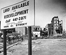
Urban renewal is a program of land redevelopment often used to address urban decay in cities. Urban renewal involves the clearing out of blighted areas in inner cities in favour of new housing, businesses, and other developments.
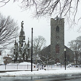
Jamaica Plain is a neighborhood of 4.4 square miles (11 km2) in Boston, Massachusetts, United States. Settled by Puritans seeking farmland to the south, it was originally part of Roxbury. The community seceded from Roxbury during the formation of West Roxbury in 1851 and became part of Boston when West Roxbury was annexed in 1874. In the 19th century, Jamaica Plain became one of the first streetcar suburbs in America and home to a significant portion of Boston's Emerald Necklace of parks, designed by Frederick Law Olmsted.
Detroit, the largest city in the state of Michigan, was settled in 1701 by French colonists. It is the first European settlement above tidewater in North America. Founded as a New France fur trading post, it began to expand during the 19th century with U.S. settlement around the Great Lakes. By 1920, based on the booming auto industry and immigration, it became a world-class industrial powerhouse and the fourth-largest city in the United States. It held that standing through the mid-20th century.
Urban decay is the sociological process by which a previously functioning city, or part of a city, falls into disrepair and decrepitude. There is no single process that leads to urban decay.

East Liberty is a neighborhood in Pittsburgh, Pennsylvania's East End. It is bordered by Highland Park, Morningside, Stanton Heights, Garfield, Friendship, Shadyside and Larimer, and falls largely within Pittsburgh City Council District 9, with a few areas in District 8. One of the most notable features in the East Liberty skyline is the East Liberty Presbyterian Church, which is an area landmark.

The Lents neighborhood in the Southeast section of Portland, Oregon is bordered by SE Powell Blvd. on the north, the Clackamas County line or City of Portland line on the south, SE 82nd Ave. to the west, and roughly SE 112th on the east. The NE corner overlaps with the Powellhurst-Gilbert neighborhood. In addition to Powellhurst-Gilbert on the north and east, Lents also borders Foster-Powell, Mt. Scott-Arleta, and Brentwood-Darlington on the west and Pleasant Valley on the east.

Downtown Columbus is the central business district of Columbus, Ohio. Downtown is centered on the intersection of Broad and High Streets, and encompasses all of the area inside the Inner Belt. Downtown is home to most of the tallest buildings in Columbus.
South Nebraska is a neighborhood within the city limits of Tampa, Florida. As of the 2000 census the neighborhood had a population of 2,908. The ZIP codes of the neighborhood are 33602 and 33605.
Mortgage discrimination or mortgage lending discrimination is the practice of banks, governments or other lending institutions denying loans to one or more groups of people primarily on the basis of race, ethnic origin, sex or religion.

The Capitol Mall or Capitol Mall Boulevard is a major street and landscaped parkway in the state capital city of Sacramento, California. Formerly known as M Street, it connects the city of West Sacramento in Yolo County to Downtown Sacramento. Capitol Mall begins at the eastern approach to the Tower Bridge, and runs east to the California State Capitol.
African-American neighborhoods or black neighborhoods are types of ethnic enclaves found in many cities in the United States. Generally, an African American neighborhood is one where the majority of the people who live there are African American. Some of the earliest African-American neighborhoods were in New Orleans, Mobile, Atlanta, and other cities throughout the American South, as well as in New York City. In 1830, there were 14,000 "Free negroes" living in New York City.
Residential segregation is the physical separation of two or more groups into different neighborhoods—a form of segregation that "sorts population groups into various neighborhood contexts and shapes the living environment at the neighborhood level". While it has traditionally been associated with racial segregation, it generally refers to the separation of populations based on some criteria.
In the United States, housing segregation is the practice of denying African Americans and other minority groups equal access to housing through the process of misinformation, denial of realty and financing services, and racial steering. Housing policy in the United States has influenced housing segregation trends throughout history. Key legislation include the National Housing Act of 1934, the G.I. Bill, and the Fair Housing Act. Factors such as socioeconomic status, spatial assimilation, and immigration contribute to perpetuating housing segregation. The effects of housing segregation include relocation, unequal living standards, and poverty. However, there have been initiatives to combat housing segregation, such as the Section 8 housing program.

West End is one of the 52 neighborhoods of Cincinnati, Ohio. Originally a large residential neighborhood, the majority of the area was demolished in the mid-20th century for the construction of highway interchanges and an industrial park known as Queensgate. The population was 6,824 at the 2020 census.

The Delmar Divide refers to Delmar Boulevard as a socioeconomic and racial dividing line in St. Louis, Missouri. The term was popularized outside Greater St. Louis by a four-minute documentary from the BBC. Delmar Blvd. is an east–west street with its western terminus in the municipality of Olivette, Missouri extending into the City of St. Louis. There is a dense concentration of eclectic commerce on Delmar Blvd. near the municipal borders of University City and St. Louis. This area is known as the Delmar Loop. Delmar Blvd. is referred to as a “divide” in reference to the dramatic difference in racial populations in the neighborhoods to its immediate north and south: as of 2012, residents south of Delmar are 73% white, while residents north of Delmar are 98% black, and because of corresponding distinct socioeconomic, cultural, and public policy differences.
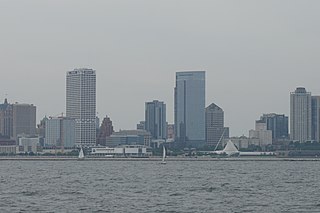
Downtown Milwaukee is the central business district of Milwaukee, Wisconsin. The economic and symbolic center of the city and the Milwaukee metropolitan area, it is Milwaukee's oldest district and home to many of region's cultural, financial educational and historical landmarks including Milwaukee City Hall, Fiserv Forum and the Milwaukee Art Museum. The city's modern history began in Downtown Milwaukee in 1795 when fur trader Jacques Vieau (1757–1852) built a post along a bluff on the east side, overlooking the Milwaukee and Menomonee rivers.