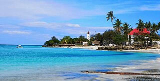
Zanzibar is an insular semi-autonomous region which united with Tanganyika in 1964 to form the United Republic of Tanzania. It is an archipelago in the Indian Ocean, 25–50 km (16–31 mi) off the coast of the African mainland, and consists of many small islands and two large ones: Unguja and Pemba Island. The capital is Zanzibar City, located on the island of Unguja. Its historic centre, Stone Town, is a World Heritage Site.

Pemba Island is a Tanzanian island forming part of the Zanzibar Archipelago, lying within the Swahili Coast in the Indian Ocean.
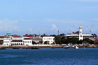
Stonetown of Zanzibar, also known as Mji Mkongwe, is the old part of Zanzibar City, the main city of Zanzibar, in Tanzania. The newer portion of the city is known as Ng'ambo, Swahili for 'the other side'. Stone Town is located on the western coast of Unguja, the main island of the Zanzibar Archipelago. Former capital of the Zanzibar Sultanate, and flourishing centre of the spice trade as well as the Indian Ocean slave trade in the 19th century, it retained its importance as the main city of Zanzibar during the period of the British protectorate. When Tanganyika and Zanzibar joined each other to form the United Republic of Tanzania, Zanzibar kept a semi-autonomous status, with Stone Town as its local government seat.
Unguja South Region, Zanzibar South Region or South Zanzibar Region is one of the 31 regions of Tanzania. The region covers an area of 854 km2 (330 sq mi). The region is comparable in size to the combined land area of the nation state of Kiribati. and the administrative region is located entirely on the island of Zanzibar. Unguja South Region is bordered on three sides to the south by Indian Ocean, northeast by Unguja North Region and northwest by Mjini Magharibi Region. The regional capital is the town of Koani. Besides being known for its Spinner dolphin populations, the region is also home to the oldest mosque in East Africa, the Kizimkazi Mosque and also historic Makunduchi town. The region has the fourth highest HDI in the country, making one of the most developed regions in the country. According to the 2022 census, the region has a total population of 195,873.

Chake-Chake is a town located on the Tanzanian island of Pemba and capital of Chake Chake District. It is in the centre of a deep indentation in the west coast called Chake-Chake Bay. Chake-Chake is historically the capital of Pemba Island, and the seat of Pemba's court. Pemba's only airport is 7 km south-east of Chake-Chake. The Mkama Ndume ruins are close to the airport in Pujini village.

Tourism in Zanzibar includes the tourism industry and its effects on the islands of Unguja and Pemba in Zanzibar a semi-autonomous region in the United Republic of Tanzania. Tourism is the top income generator for the islands, outpacing even the lucrative agricultural export industry and providing roughly 25% of income. The main airport on the island is Zanzibar International Airport, though many tourists fly into Dar es Salaam and take a ferry to the island.

Tanzania is a country with many tourist attractions. Approximately 38 percent of Tanzania's land area is set aside in protected areas for conservation. There are 17 national parks, 29 game reserves, 40 controlled conservation areas and marine parks. Tanzania is also home to Mount Kilimanjaro, the highest point in Africa.
Chwaka is a town on the Tanzanian island of Unguja, part of Zanzibar. It is located on the east coast of the island, due east of the capital Zanzibar City, on the coast of Chwaka Bay close to the edge of Jozani-Chwaka Bay National Park.

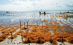
Jambiani is a group of villages on the Tanzanian island of Unguja, part of Zanzibar. It is located on the southeast coast between Paje and Makunduchi. Jambiani has a strong seaweed culture with many farms dotting the coastline and employing 15,000 locals, mainly women. Most seaweed that is farmed here is sold to the Zanea Seaweeds Ltd company and distributed around the globe. The Island of Zanzibar produces around 11,000 tons of seaweed each year, a large amount of this coming from Jambiani sources.
Jozani is a village located in Kusini District of Unguja South Region of the Tanzanian island of Unguja. It is located in the southeast of the island, 3.1 miles south of Chwaka Bay, close to the edge of the Jozani-Chwaka Bay National Park. It is primarily a farming community of about 800 people. located 21.7 miles south-east of Zanzibar Town off the road leading to Paje, Zanzibar. It is easily reached by public buses 309 and 310, by chartered taxi or as an organized tour from Zanzibar Town. These tours are often in combination with dolphin observation in Kizimkazi, one of Zanzibar's oldest settlements with a tiny 12th century mosque open to public. The main road on the island, connecting the west and east coasts of Zanzibar, also connects to Jozani. Besides public bus routes 9, 10 and 13, you can also get here from Zanzibar Town by dala-dala number 309, 310, 324, and 326. Jozani is a small and rural village, situated in the innermost part of the Pete Inlet Bay, immediately south of the Jozani Chwaka Bay National Park. It is one of six rural villages surrounding the park. Residents here depend to a large degree on the Jozani Forest as a source of firewood, hunting, building resources, farming, fishing, and more. The village also operates ecotourism in the Jozani Forest and has constructed a 0.6 mile boardwalk through the mangroves at the southern road entrance into the national park. Many villagers work as authorized guides for tours in the southern tip of Jozani Forest.
Kae is not a village, but the beach of Michamvi village on the Tanzanian island of Unguja, part of Zanzibar. It is one of two villages located in the east of the island at the northern tip of Michamvi Peninsula. It lies on the shore of Chwaka Bay, immediately to the west of the village of Pingwe.

Makunduchi is a historic town and district capital in the Kusini District of the Unguja South Region in Tanzania. It is located inside the Kajengwa ward, and Mtegani ward, occupying Kiongoni neighborhood, Nganani neighborhood and Kijini neighborhood. The town comprises two distinct settlements, about 2 km from each other, "Old Makunduchi" on the east and "New Makunduchi". Old Makunduchi is a small fishermen's village on the shore of the Indian Ocean with the Nganani mtaa (neighborhood), while New Makunduchi has some modern buildings, shops, as well as some blocks of flats that were built in the 1970s with the aid of East Germans in return for Tanzanian political support internationally. The town is also the birthplace and resting place for the 4th president of Zanzibar Idris Abdul Wakil. Makunduchi is also the birthplace of Samia Suluhu Hassan, the president of Tanzania. Other famous politicians for Makunduchi include Mohamed Gharib Bilal. Also famous novelist Muhammed Said Abdulla.
Nungwi, or Ras Nungwi, is a large village located in the far northern end of the island of Zanzibar. With a population of 30,762, Nungwi is the second largest settlement on the island. It is situated in the Nungwi Ward in the Kaskazini A District of the Unguja North Region. It is about 35 miles (56 km) north of Zanzibar Town on the Nungwi Peninsula, about an hour drive from Stone Town. To the south Nungwi shares a border with the neighboring Matemwe- and Tazari villages. Nungwi was traditionally a fishing village and dhow-building center, but is now a popular tourist destination, and for instance recognized in CNN’s list of "100 best beaches of the world" in 2014. West Nungwi has changed a lot since the 1990s and is now a popular tourist destination with numerous resorts, restaurants, bars, stores, etc. East Nungwi is quieter and generally more laid-back.
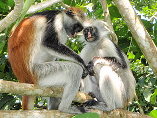
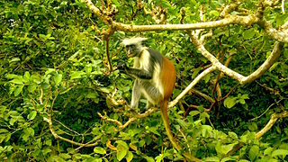
The wildlife of Zanzibar consists of terrestrial and marine flora and fauna in the archipelago of Zanzibar, an autonomous region of Tanzania. Its floral vegetation is categorized among the coastal forests of eastern Africa as the Southern Zanzibar-Inhambane coastal forest mosaic and the Northern Zanzibar-Inhambane coastal forest mosaic. Its faunal species are mostly small animals, birds, and butterflies.

The Menai Bay Conservation Area (MBCA) is located in Menai Bay, Zanzibar Tanzania. At 470 square kilometres (180 sq mi), it is Zanzibar's largest marine protected area. It was officially established as a conservation area in August 1997 in the traditional fishing area, known as Unguja Island, covering the tropical marine environment comprising extensive coral reefs, tropical fish, sea grasses, and mangrove forests. In addition to controlling illegal fishing, MBCA's alternative initiatives have included bee keeping, mangrove replanting, tree nurseries and tourism. The management of the MBCA falls upon the Fisheries Department and the bay's local villages. It is rated by the IUCN as Category VI Managed Resource Protected Area.

Malindi Mosque is a mosque in Stone Town, Zanzibar, Tanzania, located near the port. It stems from the 1830s but was possibly built on the site of an elder mosque that might have dated back to the 17th century or earlier. Some travel guides claim an origin in the 15th century.
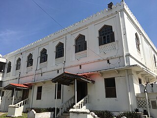
Ijumaa Mosque is a mosque in Stone Town, Zanzibar, Tanzania. The mosque was completely renovated in 1994 in the modern arabesque style.
Fatuma binti Yusuf al-Alawi was a queen of Unguja in pre-Sultanate Zanzibar. A supporter of the Portuguese in their war against Oman, she sent supplies to the Europeans at the Siege of Fort Jesus. She was captured during the subsequent Omani occupation of Zanzibar and exiled to Oman. Allowed to return in 1709 she ruled the island as a client state of Oman for the rest of her life.
Zanzibari independence is a political ambition of some political parties, advocacy groups, and individuals of Zanzibar, a semi-autonomous region territory within Tanzania, to become an independent sovereign state.