Related Research Articles

The Tocantins River is a river in Brazil, the central fluvial artery of the country. In the Tupi language, its name means "toucan's beak". It runs from south to north for about 2,450 km. It is not really a branch of the Amazon River, since its waters flow into the Atlantic Ocean alongside those of the Amazon. It flows through four Brazilian states and gives its name to one of Brazil's newest states, formed in 1988 from what was until then the northern portion of Goiás.

Tocantins is one of the 26 states of Brazil. It is the newest state, formed in 1988 and encompassing what had formerly been the northern two-fifths of the state of Goiás. Tocantins covers 277,620.91 square kilometres (107,190.03 sq mi) and had an estimated population of 1,496,880 in 2014. Construction of its capital, Palmas, began in 1989; most of the other cities in the state date to the Portuguese colonial period. With the exception of Araguaína, there are few other cities with a significant population in the state. The government has invested in a new capital, a major hydropower dam, railroads and related infrastructure to develop this primarily agricultural area. The state has 0.75% of the Brazilian population and is responsible for 0.5% of the Brazilian GDP.

Brazil is geopolitically divided into five regions, by the Brazilian Institute of Geography and Statistics, which are formed by the federative units of Brazil. Although officially recognized, the division is merely academic, considering geographic, social and economic factors, among others, and has no political effects other than orientating Federal-level government programs. Under the state level, they are further divided into intermediate regions and even further into immediate regions.

The Araguaia River is one of the major rivers of Brazil though it is almost equal in volume at its confluence with the Tocantins. It has a total length of approximately 2,627 km.

The Pará River, also called Parauaú River, Jacaré Grande River, Marajó River Channel, Macacos River Channel, Santa Maria River Channel and Bocas Bay, is a watercourse and immense estuarine complex that functions as a canal between the rivers Amazon, Tocantins, Campina Grande and Marajó Bay, in addition to numerous other smaller rivers. It can also be considered a distributary channel of the Tocantins River.
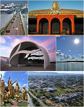
Palmas is the capital and largest city of the state of Tocantins, Brazil. According to IBGE estimates from 2020, the city had 306,296 inhabitants.
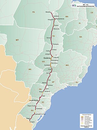
BR-153 is a major federal highway of Brazil, officially named the Transbrasiliana Highway. It also serves as part of the Belém–Brasília Highway in the stretch located between the cities of Wanderlândia, in the state of Tocantins, and Anápolis, in the state of Goiás.

The Araguaia National Park is a national park located in Tocantins state in the north of Brazil, between 09º51’—11º11’S and 49º57’—50º27’W. Bananal Island, on which the park is located, is believed to be the largest inland river island in the world.

Monte Alegre de Goiás is a municipality in northeastern Goiás state, Brazil.

Aurora do Tocantins is a municipality located in the Brazilian state of Tocantins. Its population is 3,783 (2020) and its area is 753 km².

Couto Magalhães is a municipality located in the Brazilian state of Tocantins. Its population was 5,639 (2020) and its area is 1,586 km² (612.4 mi²), a density of 3.07 people/km². It is located 150 m (492.1 ft) above sea level. The demonym is Coutense.
Santo Augusto is a municipality in Rio Grande do Sul, Brazil, in the micro region of Ijuí. As of 2020, the estimated population was 13,848.
The Escuro River is a river of Tocantins state in central Brazil.
Tapiramutá is a municipality in the state of Bahia in the North-East region of Brazil.
Figueirópolis is a municipality in the state of Tocantins in the Northern region of Brazil.
São Salvador do Tocantins is a municipality in the state of Tocantins in the Northern region of Brazil.
Divinópolis do Tocantins is a municipality in the state of Tocantins in the Northern region of Brazil.
Marianópolis do Tocantins is a municipality in the state of Tocantins in the Northern region of Brazil.
Rio da Conceição is a municipality in the state of Tocantins in the Northern region of Brazil.
Monte do Carmo is a municipality in the state of Tocantins in the Northern region of Brazil.
References
Coordinates: 10°51′S49°47′W / 10.850°S 49.783°W