Year 7 BC was a common year starting on Saturday or Sunday of the Julian calendar and a common year starting on Thursday of the Proleptic Julian calendar. In the Roman world, it was known as the Year of the Consulship of Tiberius and Piso. The denomination 7 BC for this year has been used since the early medieval period, when the Anno Domini calendar era became the prevalent method in Europe for naming years.
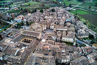
Bevagna is a town and comune in the central part of the Italian province of Perugia (Umbria), in the flood plain of the Topino river.

Symi, also transliterated as Syme or Simi, is a Greek island and municipality. It is mountainous and has the harbour town of Symi and its adjacent upper town Ano Symi, as well as several smaller population centres, beaches and areas of significance in history and mythology. Symi is part of the Rhodes regional unit.

The sextans was an Ancient Roman bronze coin produced during the Roman Republic valued at one-sixth of an as. An as was roughly 324 grams in weight, thus leaving the sextans at about 54 grams. However, the effects of the Second Punic War on the Republic's economy resulted in a reduction in weight, where the as reduced to about 50 grams, resulting in the sextans weighing about 8 grams. The most common design for the sextans was the bust of Mercury and two pellets on the obverse and the prow of a galley on the reverse. Earlier types depicted a scallop shell, a caduceus, or other symbols on the obverse.

The Atbarah River, also referred to as the Red Nile and / or Black Nile, is a river in northeast Africa. It rises in northwest Ethiopia, approximately 50 km north of Lake Tana and 30 km west of Gondar. It then flows about 805 km (500 mi) to the Nile in north-central Sudan, joining it at the city of Atbarah. The river's tributary, the Tekezé (Setit) River, is perhaps the true upper course of the Atbarah, as the Tekezé follows the longer course prior to the confluence of the two rivers in northeastern Sudan. The Atbarah is the last tributary of the Nile before it reaches the Mediterranean.
LacusCurtius is the ancient Graeco-Roman part of a large history website, currently hosted on a server at the University of Chicago. It went online on August 26, 1997, a few weeks before both Wikipedia and Google; in October 2024 it had "3916 webpages, 779 photos, 772 drawings & engravings, 120 plans, 139 maps." The overall site is the creation of William P. Thayer.

Otricoli is a town and comune in the province of Terni, Umbria, central Italy. It is located on the Via Flaminia, near the east bank of the Tiber, some 70 km north of Rome and 20 km south of Narni.

Hispellum was an ancient town of Umbria, Italy, 6 km (3.7 mi) north of Fulginiae on the road to Perusia.
An ergastulum was a Roman workhouse building used as a type of factory with slaves held in chains or to punish slaves. The ergastulum was usually built as a deep, roofed pit below ground level, large enough to allow the slaves to work within it, and containing narrow spaces in which they slept. Ergastula were common structures on all slave-using farms (latifundia). The etymology is disputed between two possible Greek roots: ergasterios "workshop" and ergastylos "pillar to which slaves are tethered."

Cannara is a town and comune on the Topino River in the floodplain of central Umbria, in the province of Perugia. It is located about 7 km west of Spello and 9 km north of Bevagna.
A panegyris, is an Ancient Greek general, national or religious assembly. Each was dedicated to the worship of a particular god. It is also associated with saint days and holy festivals. Panegyris is used in three ways: A meeting of the inhabitants from one town and its vicinity, a meeting of inhabitants of an entire province, district, or of people belonging to a particular tribe, and for national meetings. The panegyreis were festivals in which prayers were made, sacrifices offered, and also processions.

Pollice verso or verso pollice is a Latin phrase, meaning "with a turned thumb", that is used in the context of gladiatorial combat. It refers to a hand gesture or thumb signal used by Ancient Roman crowds to pass judgment on a defeated gladiator following duels in colloseums.
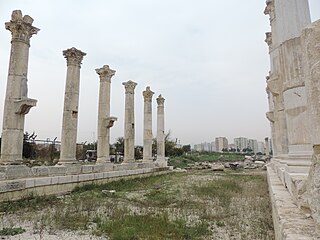
Soli, often rendered Soli/Pompeiopolis, was an ancient city and port in Cilicia, 11 km west of Mersin in present-day Turkey.
Sareisa or Shareisha was an ancient city in southeast Anatolia, near Tigris. It is mentioned by Strabo as a city of Cordyene. Ancient Assyrian inscriptions mention it as 'Shareisha' or 'Shereshe'; Tiglath-Pileser I reports his conquest of the city and defeat of the forces of Kurte.
The Porticus Vipsania, also known as the Portico of Agrippa, was a portico near the Via Flaminia in the Campus Agrippae of ancient Rome, famed for its map of the world. It was designed by Marcus Vipsanius Agrippa and constructed by his sister Vipsania Polla after Agrippa died. The map was named either directly after Vipsania Polla or the gens Vipsania, which Polla and her brother Agrippa belonged to.
The Senses, or Sense, were a Dacian tribe in the southern region of Dacia.
The Battle of the Isère River took place near the modern day French town of Valence at the confluence of the Isère and Rhône rivers. A first confrontation had been won by Gnaeus Domitius Ahenobarbus at the Battle of Vindalium, further south in the Rhône Valley, before Ahenobarbus and Quintus Fabius Maximus Allobrogicus joined their forces, defeating a confederation of Allobroges, Arverni and some Salluvii warriors at the Isère River.
The Battle of Myus was a military engagement that took place in 311 BC. The battle occurred in Syria or more generally, the Levant, at an unknown location named Myus, between an Antigonid force led by Demetrius I Poliorcetes and a Ptolemaic force under the command of a close associate of Ptolemy, Cilles. It concluded with an Antigonid victory, permitting to mitigate the defeat of Gaza, and likely led to the Peace of 311 BC among the various Diadochi.
Cilles was a Macedonian Greek general of the 4th century BC. He served Ptolemy I and was defeated by Demetrius I Poliorcetes at the Battle of Myus in 311 BC.


