
The Chagga is a Bantu ethnic group from Kilimanjaro Region of Tanzania and Arusha Region of Tanzania. They are the third-largest ethnic group in Tanzania. They historically lived in sovereign Chagga states on the slopes of Mount Kilimanjaro in both Kilimanjaro Region and Arusha Region.

Danieri Basammula-Ekkere Mwanga II Mukasa was the 31st Kabaka of Buganda who ruled from 1884 until 1888 and from 1889 until 1897.

Kilimanjaro Region is one of Tanzania's 31 administrative regions. The regional capital and largest city is the municipality of Moshi. With the 3rd highest HDI of 0.640 in the country, Kilimanjaro is one among the top five most developed regions of Tanzania. According to the 2012 national census, the region had a population of 1,640,087, which was lower than the pre-census projection of 1,702,207. For 2002–2012, the region's 1.8 percent average annual population growth rate was the 24th highest in the country. It was also the eighth most densely populated region with 124 people per square kilometer. The most well-known tribes in the Kilimanjaro region are the Chaga.

Tanga Region is one of Tanzania's 31 administrative regions. The region covers an area of 26,667 km2 (10,296 sq mi). The region is comparable in size to the combined land area of the nation state of Burundi. The regional capital is the municipality of Tanga city. Located in northeast Tanzania, the region is bordered by Kenya and Kilimanjaro Region to the north; Manyara Region to the west; and Morogoro and Pwani Regions to the south. It has a coastline to the east with the Indian Ocean. According to the 2022 national census, the region had a population of 2,615,597.
The Pare are a Bantu ethnic group. Their ancestral home is on the Pare Mountains of Same District and Mwanga District of Kilimanjaro Region in Northerneast Tanzania.

Same is one of the seven districts of the Kilimanjaro Region of Tanzania. It is bordered to the north by the Mwanga District, to the northeast by Kenya, to the south and southeast by the Korogwe District and Lushoto District of Tanga Region, and to the west by Simanjiro District of Manyara Region. The district capital is the town of Same, Tanzania. The south Pare Mountains are located within the district's boundaries and so is a part of Mkomazi National Park. According to the 2002 Tanzania National Census, the population of the Same District was 212,235. The population had risen to 300,303 according to the 2022 Tanzania National Census.
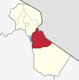
Mwanga is one of the seven districts of the Kilimanjaro Region of Tanzania. The district covers an area of 1,831 km2 (707 sq mi), It is bordered to the northeast by Kenya, to the northwest by the Moshi Rural District, to the southwest by Simanjiro District of Manyara Region, and to the south by the Same District. Its administrative seat is the town of Mwanga. The tallest peak in the district is Kindoroko at 2,100m in the North Pare Mountains that are located entirely within the district. According to the 2022 Tanzania National Census, the population of Mwanga District was 148,763.

The Pare Mountains are a mountain range in northeastern Tanzania, located north of the Usambara Mountains. The mountains are administratively located in the Kilimanjaro Region, specifically in the Mwanga District and Same District. The North and South Pare mountain ranges reach a height of 2,464 meters at Shengena Peak. They are separated into North Pare Mountains and South Pare Mountains and are part of the Eastern Arc of mountains. The mountains are named after the indigenous Pare people who reside there.

The Shambaa people, also called the Sambaa, Shambala, Sambala or Sambara, are a Nilotic ethnic group. The Sambaa people related to Masai people,Their ancestral home is on the Usambara Mountains of Lushoto District, Korogwe District and Bumbuli District. They are native to the valleys and eastern Usambara Mountains of Korogwe District, Korogwe Urban District and western Muheza District of northern Tanga Region of Tanzania. The word Shamba means "farm", and these people live in one of the most fertile Tanzanian region. Shambaai in Kisambaa means "where the banana's thrive". In 2001, the Shambaa population was estimated to number 664,000.
The Uluguru mountains are a mountain range in eastern Tanzania, named after the Luguru tribe. The main portion of the Uluguru mountains is a ridge running roughly north-south and rising to 2,630 metres (8,600 ft) altitude at its highest point. On the main Uluguru range, 50 villages touch the forest boundary and over 151,000 people are found within the mountain area, often at increasing densities at higher altitudes up to the forest boundary.
Kilomeni is a ward in the Mwanga District of the Kilimanjaro Region of Tanzania and is situated in the Pare Mountains. Kilomeni is home to a Roman Catholic parish, a secondary school, and a primary school. According to the 2012 census, the population of the ward was 4,467. The local people of kilomeni are The Pare.
The Roman Catholic Diocese of Same is a diocese located in the Same District in the ecclesiastical province of Arusha in Tanzania.

The following outline is provided as an overview of and topical guide to Tanzania:

Lake Jipe is an inter-territorial lake straddling the borders of Kenya and Tanzania. On the Kenyan side, it is located south of the village of Nghonji while on the Tanzanian side, it is situated within Mwanga District, in Kilimanjaro Region. The lake is fed mainly by the Lumi River, which descends from Mount Kilimanjaro, as well as streams from the North Pare Mountains, being on the leeward side. The lake's outlet forms the Ruvu River. Kenya's unfenced Tsavo West National Park protects part of the lake's northern shore, while on the Tanzania side Mkomazi Game Reserve is nearby. The lake is known for its endemic fish, as well as water birds, mammals, wetland plants and lake-edge swamps, which can extend 2 kilometres (1.2 mi) from Jipe's shore.
Ugweno is located within the Mwanga District, Kilimanjaro Region, Tanzania, Africa. It is situated at 3° 39' 0" South and 37° 39' 0" East in the Pare Mountains. The people who live in Ugweno are known as Wagweno and their common language is Kigweno.
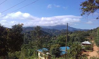
The North Pare Mountains is a mountain range located entirely within Mwanga District of Kilimanjaro Region of northern Tanzania, extending from Ruvu River on the border with Moshi Rural District to Mgagao Ward in on the border with Same District. The range is part of East Africa's Eastern Arc Mountains chain known as the Pare Mountains. The other range is the South Pare Mountains. The North Pare and South Pare mountains are named after the original inhabitants of the area, the Pare people. The average elevation of the highlands is 1613m. The highest peak in the North Pare is Kindoroko Peak at 2,100m. The North Pare Mountains are divided into four ranges, Mramba in the northeast, Ngofe in the north, Mruma in the center, and Mwanga Ndorowe to the south. The mountains are also home to archaeological sites of ancient iron smithing done by the ancestors of the Pare. Currently, there are three protected forests on the mountain range; Kindoroko, Minja, and Mramba forest reserves.
The South Pare Mountains is a mountain range located entirely within Same District of Kilimanjaro Region of northern Tanzania, extending from Vumari ward on the border with Mwanga District to Kalemawe ward in on the border with Lushoto District in Tanga Region. The range is part of the Eastern Arc Mountains chain in East Africa. With the North Pare Mountains they make up the Pare Mountains chain. The North and South Pare mountains are named after the original inhabitants of the area, the Pare people. The highest peak in South Pare is Shengena Peak at 2,463m.
Kisangara River(Mto Kisangara in Swahili) is located in the central Kilimanjaro Region, Tanzania. It begins in North Pare Mountains in Mwanga District and drains in the Nyumba ya Mungu Reservoir on the border with Simanjiro District in Manyara Region.
The Mbugu people, also known as the Va'maa, Ma'a are an ethnic Bantu and linguistic group hailing from western Usambara Mountains of Lushoto District in Tanga Region of Tanzania. Tanzania's Mbugu language is one of the few true hybrid languages, combining Bantu grammar with Cushitic lexicon. In actuality, the people speak two languages: one closely related to Pare and the other mixed. They are approximately 60,000 living Mbugu people.

Ruvu Jipe River, also known as Luffu and Jipe Ruvu and Ruvu Pangani, is located in northern Kilimanjaro Region's Mwanga District of Tanzania. It begins in Kileo ward at Lake Jipe and eventually drains into Nyumba ya Mungu Dam and into Pangani River at Lang'ata ward.
