Utica is a city in the Mohawk Valley and the county seat of Oneida County, New York, United States. The tenth-most-populous city in New York State, its population was 65,283 in the 2020 U.S. Census. Located on the Mohawk River at the foot of the Adirondack Mountains, it is approximately 95 mi (153 km) west-northwest of Albany, 55 mi (89 km) east of Syracuse and 240 mi (386 km) northwest of New York City. Utica and the nearby city of Rome anchor the Utica–Rome Metropolitan Statistical Area comprising all of Oneida and Herkimer Counties.

The 4 Lexington Avenue Express is a rapid transit service in the A Division of the New York City Subway. Its route emblem, or "bullet", is colored forest green since it uses the IRT Lexington Avenue Line in Manhattan.

Flatbush Avenue is a major avenue in the New York City Borough of Brooklyn. It runs from the Manhattan Bridge south-southeastward to Jamaica Bay, where it joins the Marine Parkway–Gil Hodges Memorial Bridge, which connects Brooklyn to the Rockaway Peninsula in Queens. The north end was extended from Fulton Street to the Manhattan Bridge as "Flatbush Avenue Extension".

Utica was an ancient Phoenician and Carthaginian city located near the outflow of the Medjerda River into the Mediterranean, between Carthage in the south and Hippo Diarrhytus in the north. It is traditionally considered to be the first colony to have been founded by the Phoenicians in North Africa. After Carthage's loss to Rome in the Punic Wars, Utica was an important Roman colony for seven centuries.

The Battle of the Bagradas River was fought between a Carthaginian army led by Hamilcar Barca and a rebel force led by Spendius in 240 BC in what is now north-east Tunisia. Carthage was fighting a coalition of mutinous soldiers and rebellious African cities in the Mercenary War, which had started late the previous year in the wake of the First Punic War. The rebels were blockading Carthage and besieging the northern ports of Utica and Hippo. A Carthaginian army commanded by Hanno had attempted and failed to relieve Utica early in 240 BC. A second army was assembled in Carthage and entrusted to Hamilcar, who had commanded Carthaginian forces on Sicily for the last six years of the First Punic War.

New York State Route 12 (NY 12) is a state highway extending for 222.27 miles (357.71 km) through central and northern New York in the United States. The southern terminus of the route is at U.S. Route 11 (US 11) in the town of Chenango in the Southern Tier. The northern terminus is at NY 37 near the village of Morristown in the North Country. In between, the route serves three cities of varying size: Norwich, Utica, and Watertown. NY 12 intersects several primary routes, including US 20 in Sangerfield, New York State Thruway via Interstate 790 (I-790) in Utica, overlaps NY 28 from Barneveld to the town of Remsen, NY 3 in Watertown, and I-81 in Pamelia and Orleans.

Utica is a town and municipality in the Cundinamarca Department, Colombia located some 127 kilometers from Bogotá. The village lies at an altitude of 506 meters above sea level and has an average daily temperature of 26 °C.

Illinois Route 178 is a minor north–south state highway in north central Illinois. It runs north from the unincorporated area of Lowell to Interstate 80 about 3 miles (4.8 km) north of North Utica, which is better known as simply Utica. This is a distance of 8.49 miles (13.66 km).

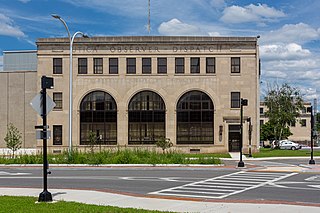
The Observer-Dispatch is a newspaper serving the Utica-Rome metropolitan area in Central New York, circulating in Oneida County, Herkimer County, and parts of Madison County. Based in Utica, New York, the publication is owned by Gannett.

New York State Route 8 (NY 8) is a 207.45-mile-long (333.86 km) north-south state highway in the central part of New York in the United States. It runs in a southwest-to-northeast direction from the Southern Tier to the northern part of Lake George. The southern terminus of the route is at an interchange with NY 17, where it begins concurrent with NY 10 in the town of Deposit. Its northern terminus is at a junction with NY 9N in the town of Hague. Roughly midway between the two endpoints, NY 8 passes through Utica, where it overlaps NY 5, NY 12, and Interstate 790 (I-790) along one segment of the North–South Arterial.

New York State Route 49 (NY 49) is an east–west state highway in central New York in the United States. It runs for just over 64 miles (103 km) from an intersection with NY 3 in the town of Volney in Oswego County, New York to an interchange with Interstate 790 (I-790), NY 5, NY 8 and NY 12 in the city of Utica in Oneida County. The route follows a generally northwest–southeast alignment between the two points, passing along the north shore of Oneida Lake and directly serving the city of Rome. As NY 49 heads east, it connects to several highways of regional importance, such as I-81 in the village of Central Square and NY 13 in the town of Vienna. Most of NY 49 is a two-lane surface road; however, the section between Rome and Utica is a freeway known as the Utica–Rome Expressway.

New York State Route 5S (NY 5S) is a 72.92-mile-long (117.35 km) east–west state highway located in the Mohawk Valley of New York in the United States. It extends from a continuation of NY 5A at an interchange with I-790, NY 5, NY 8, and NY 12 in Utica to an interchange with I-890 and NY 890 in Rotterdam. The route runs along the south side of the Mohawk River for its entire length and parallels NY 5, which runs along the north side of the Mohawk River. NY 5S intersects several primary routes including NY 28 in Mohawk, NY 30A in Fultonville, NY 30 south of Amsterdam, as well as intersecting the New York State Thruway (I-90) several times. The route is part of New York State Bicycle Route 5 west of its junction with NY 103 in Schenectady County.

Frederick James Sisson was an American educator, lawyer, and politician who served two terms as a United States representative from New York from 1933 to 1937.

Utica University is a private university in Utica, New York. The university has a main campus in Utica; the Robert Brvenik Center for Business Education, in downtown Utica; and satellite locations in Syracuse, New York; Latham, New York; and St. Petersburg, Florida.

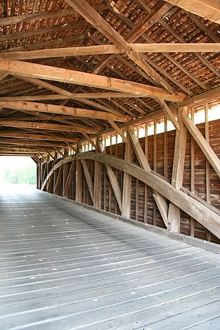
The Utica Road Covered Bridge is a Burr truss wooden covered bridge located near Lewistown, Maryland. Originally built in 1834, it spanned the Monocacy River at the Devilbiss Bridge crossing. An 1889 flood damaged the bridge and the surviving half was moved to Fishing Creek in 1891. Like the nearby Loys Station Covered Bridge, a pier was inserted at the middle of the bridge to halve its span.

Campbell W. Adams was an American civil engineer, surveyor and politician from New York. He was New York State Engineer and Surveyor from 1894 to 1898.

The Utica Comets are a professional ice hockey team based in Utica, New York, with home games at the Adirondack Bank Center. They are members of the North Division in the Eastern Conference of the American Hockey League (AHL) and affiliated with the National Hockey League's (NHL) New Jersey Devils. The team was established when the Vancouver Canucks relocated their AHL franchise to Utica for the 2013–14 season.
Utica, also known as Utica Mills, is an unincorporated community located in Frederick County, Maryland, United States, at the intersection of Old Frederick Road and Lenhart Road.

The B46 bus route constitutes a public transit corridor in Brooklyn, New York City. The route runs primarily along Utica Avenue north from the Kings Plaza shopping center through Eastern Brooklyn, with continued service west along Broadway to the Williamsburg Bridge Plaza Bus Terminal. The corridor was originally served by a streetcar line, known as the Utica and Reid Avenues Line, Utica−Reid Line, Reid−Utica Line, Reid Avenue Line, or Utica Avenue Line until 1951, when the line was replaced by bus service. The bus route is operated by MTA Regional Bus Operations under the New York City Transit brand.


