A road is a thoroughfare for the conveyance of traffic that mostly has an improved surface for use by vehicles and pedestrians. Unlike streets, whose primary function is to serve as public spaces, the main function of roads is transportation.

A sidewalk, pavement, footpath in Australia, India, New Zealand and Ireland, or footway is a path along the side of a road. Usually constructed of concrete, pavers, brick, stone, or asphalt, it is designed for pedestrians. A sidewalk is normally higher than the roadway, and separated from it by a kerb. There may also be a planted strip between the sidewalk and the roadway and between the roadway and the adjacent land.

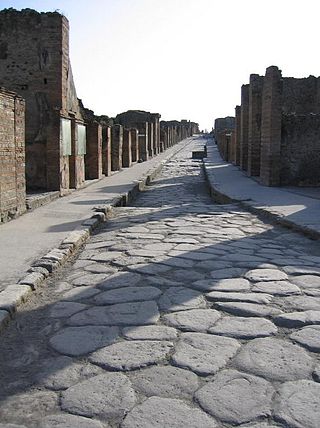
A street is a public thoroughfare in a built environment. It is a public parcel of land adjoining buildings in an urban context, on which people may freely assemble, interact, and move about. A street can be as simple as a level patch of dirt, but is more often paved with a hard, durable surface such as tarmac, concrete, cobblestone or brick. Portions may also be smoothed with asphalt, embedded with rails, or otherwise prepared to accommodate non-pedestrian traffic.

A road surface or pavement is the durable surface material laid down on an area intended to sustain vehicular or foot traffic, such as a road or walkway. In the past, gravel road surfaces, macadam, hoggin, cobblestone and granite setts were extensively used, but these have mostly been replaced by asphalt or concrete laid on a compacted base course. Asphalt mixtures have been used in pavement construction since the beginning of the 20th century and are of two types: metalled (hard-surfaced) and unmetalled roads. Metalled roadways are made to sustain vehicular load and so are usually made on frequently used roads. Unmetalled roads, also known as gravel roads or dirt roads, are rough and can sustain less weight. Road surfaces are frequently marked to guide traffic.

Asphalt concrete is a composite material commonly used to surface roads, parking lots, airports, and the core of embankment dams. Asphalt mixtures have been used in pavement construction since the beginning of the twentieth century. It consists of mineral aggregate bound together with bitumen, laid in layers, and compacted.

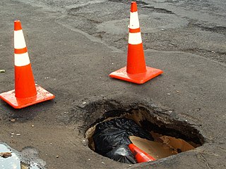
A pothole is a depression in a road surface, usually asphalt pavement, where traffic has removed broken pieces of the pavement. It is usually the result of water in the underlying soil structure and traffic passing over the affected area. Water first weakens the underlying soil; traffic then fatigues and breaks the poorly supported asphalt surface in the affected area. Continued traffic action ejects both asphalt and the underlying soil material to create a hole in the pavement.

Utility location is the process of identifying and labeling public utility mains that are underground. These mains may include lines for telecommunication, electricity distribution, natural gas, cable television, fiber optics, traffic lights, street lights, storm drains, water mains, and wastewater pipes. In some locations, major oil and gas pipelines, national defense communication lines, mass transit, rail, and road tunnels also compete for space underground.

Portuguese pavement, known in Portuguese as calçada portuguesa or simply calçada, is a traditional-style pavement used for many pedestrian areas in Portugal. It consists of small pieces of stone arranged in a pattern or image, like a mosaic. It can also be found in Olivença and throughout former Portuguese colonies, especially in Brazil. Portuguese workers are also hired for their skill in creating these pavements in places such as Gibraltar. Being usually used in sidewalks, it is in town squares and atriums that this art finds its deepest expression.

Snow removal or snow clearing is the job of removing snow after a snowfall to make travel easier and safer. This is done both by individual households and by governments, institutions, and commercial businesses.

Road surface marking is any kind of device or material that is used on a road surface in order to convey official information; they are commonly placed with road marking machines. They can also be applied in other facilities used by vehicles to mark parking spaces or designate areas for other uses. In some countries and areas, road markings are conceived as horizontal traffic signs, as opposed to vertical traffic signs placed on posts.
Object hyperlinking is a term that refers to extending the Internet to objects and locations in the real world. Object hyperlinking aims to extend the Internet to the physical world by attaching tags with URLs to tangible objects or locations. These object tags can then be read by a wireless mobile device and information about objects and locations retrieved and displayed.

A curb, or kerb, is the edge where a raised sidewalk or road median/central reservation meets a street or other roadway.

Chipseal is a pavement surface treatment that combines one or more layer(s) of asphalt with one or more layer(s) of fine aggregate. In the United States, chipseals are typically used on rural roads carrying lower traffic volumes, and the process is often referred to as asphaltic surface treatment. This type of surface has a variety of other names including tar-seal or tarseal, tar and chip, sprayed sealsurface dressing, or simply seal.
Maxwell Products, Inc. is a privately held, pavement maintenance products manufacturing company based in Salt Lake City, Utah. Founded in 1975 by brothers Ted and Delwyn Maxwell, Maxwell Products manufactures asphalt and concrete pavement preservation products, including Elastoflex crack and concrete joint sealant, NUVO premium crack and concrete joint sealant, GAP Mastic, and GAP Patch.

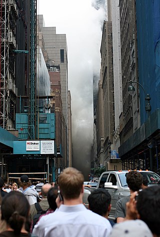
On July 18, 2007, an explosion in Manhattan, New York City, sent a geyser of hot steam up from beneath a busy intersection, with a 40-story-high shower of mud and flying debris raining down on the crowded streets of Midtown Manhattan. It was caused by the failure of an 83-year-old, 24-inch (0.61 m) underground steam pipe near Grand Central Terminal, which exploded during the evening rush hour. 45 people were injured, and one woman died of a heart attack while fleeing.

R.S. Blome Granitoid Pavement is a historic road surface, as well as the associated cut sandstone curbs in a few sections, found in three of the oldest residential sections of Grand Forks, North Dakota. It is a Portland cement–aggregate combination that was intended to bridge the gap between the needs of Horse-drawn vehicles, which required sure footing, and automobiles, which needed a hard, resilient surface, in the earliest part of the 20th century.
A human microchip implant is any electronic device implanted subcutaneously (subdermally) usually via an injection. Examples include an identifying integrated circuit RFID device encased in silicate glass which is implanted in the body of a human being. This type of subdermal implant usually contains a unique ID number that can be linked to information contained in an external database, such as identity document, criminal record, medical history, medications, address book, and other potential uses.

The Kenton Library is a branch of the Multnomah County Library (MCL), in the Kenton neighborhood of Portland in the U.S. state of Oregon. Preceded by reading rooms in North Portland and later by the Lombard Branch Library, the Kenton Library opened in 2010 in a storefront on North Denver Avenue. The branch offers the MCL catalog of two million books, periodicals and other materials.

Pavement lights (UK), vault lights (US), floor lights, or sidewalk prisms are flat-topped walk-on skylights, usually set into pavement (sidewalks) or floors to let sunlight into the space below. They often use anidolic lighting prisms to throw the light sideways under the building. They were developed in the 19th century, but declined in popularity with the advent of cheap electric lighting in the early 20th. Older cities and smaller centers around the world have, or once had, pavement lights. In the early 21st century, such lights are approximately a century old, although lights are being installed in some new construction.

A utility cut is a cut and excavation to an existing road surface to install or repair subterranean public utility conduits and equipment. After the utility is installed or repaired, the road needs to be restored which will result in patches on the road surface. Due to a different settling rate of the backfill material relative to the original pavement, the road surface condition may be deteriorated after the road restoration. This will require ongoing maintenance and repairs.


