The Uyghurs, alternatively spelled Uighurs, Uygurs or Uigurs, are a Turkic ethnic group originating from and culturally affiliated with the general region of Central and East Asia. The Uyghurs are recognized as the titular nationality of the Xinjiang Uyghur Autonomous Region in Northwest China. They are one of China's 55 officially recognized ethnic minorities. The Uyghurs are recognized by the Chinese government as a regional minority and the titular people of Xinjiang.

East Turkestan or East Turkistan, also called Uyghuristan, is a loosely-defined geographical region in the northwestern part of the People's Republic of China, which varies in meaning by context and usage. The term was coined in the 19th century by Russian Turkologists, including Nikita Bichurin, who intended the name to replace the common Western term for the region, "Chinese Turkestan", which referred to the Tarim Basin in Southern Xinjiang or Xinjiang as a whole during the Qing dynasty. Beginning in the 17th century, Altishahr, which means "Six Cities" in Uyghur, became the Uyghur name for the Tarim Basin. Uyghurs also called the Tarim Basin "Yettishar," which means "Seven Cities," and even "Sekkizshahr", which means "Eight Cities" in Uyghur. Chinese dynasties from the Han dynasty to the Tang dynasty had called an overlapping area the "Western Regions".

Turpan is a prefecture-level city located in the east of the autonomous region of Xinjiang, China. It has an area of 69,759 square kilometres (26,934 sq mi) and a population of 693,988 (2020).

The Turkic Islamic Republic of East Turkestan (TIRET) was a breakaway Islamic republic centered on the city of Kashgar, located in the far west of China's Xinjiang Province. It is often described as the First East Turkestan Republic to differentiate it from the Second East Turkestan Republic (1944–1946), but "first" was never a part of its official name.

Shanshan County as the official romanized name, also transliterated from Uyghur as Piqan County, is a county within the Xinjiang Uyghur Autonomous Region and is under the administrative jurisdiction of the prefecture-level city of Turpan. It contains an area of 39,548 km2 (15,270 sq mi), occupying the eastern majority of Turpan. According to the 2002 census, it has a population of 210,000.

The Turpan water system or Turfan karez system Uyghur: كارىز, romanized: kariz) in Turpan, located in the Turpan Depression, Xinjiang, China, is a vertical tunnel system adapted by the Uyghur people. The word karez means "well" in the local Uyghur language. Turpan has the Turpan Karez Paradise museum dedicated to demonstrating its karez water system, as well as exhibiting other historical artifacts.

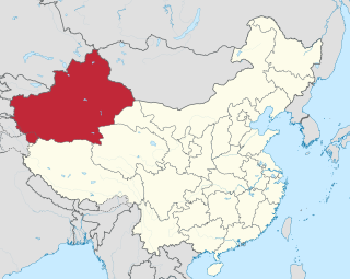
Xinjiang, officially the Xinjiang Uygur Autonomous Region, is an autonomous region of the People's Republic of China (PRC), located in the northwest of the country at the crossroads of Central Asia and East Asia. Being the largest province-level division of China by area and the 8th-largest country subdivision in the world, Xinjiang spans over 1.6 million square kilometres (620,000 sq mi) and has about 25 million inhabitants. Xinjiang borders the countries of Afghanistan, Kazakhstan, Kyrgyzstan, Mongolia, Pakistan, Russia, Tajikistan, and India. The rugged Karakoram, Kunlun and Tian Shan mountain ranges occupy much of Xinjiang's borders, as well as its western and southern regions. The Aksai Chin and Trans-Karakoram Tract regions are claimed by India but administered by China. Xinjiang also borders the Tibet Autonomous Region and the provinces of Gansu and Qinghai. The most well-known route of the historic Silk Road ran through the territory from the east to its northwestern border.

Khoja Niyaz, also Khoja Niyaz Haji, was a Uyghur independence movement leader who led several rebellions in Xinjiang against the Kumul Khanate, the Chinese governor Jin Shuren and later the Hui warlord Ma Zhongying. He is best remembered as the first and only president of the short-lived Islamic Republic of Eastern Turkestan from November 1933 until the republic's defeat in 1934.
The history of the Uyghur people extends over more than two millennia and can be divided into four distinct phases: Pre-Imperial, Imperial, Idiqut, and Mongol, with perhaps a fifth modern phase running from the death of the Silk Road in AD 1600 until the present.

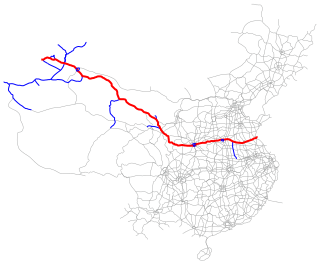
The Lianyungang–Khorgas Expressway, designated as G30 and commonly referred to as the Lianhuo Expressway, is 4,243-kilometre-long expressway (2,636 mi) in China that connects the cities of Lianyungang, in the province of Jiangsu, and Khorgas, in the autonomous region of Xinjiang, on the border with Kazakhstan. At Khorgas, there is a border crossing into Kazakhstan. The expressway is the longest contiguous expressway in China with a single numeric designation, stretching across the country from the Yellow Sea on the east coast to the Kazakhstan border in the west. It passes through the provinces of Jiangsu, Anhui, Henan, Shaanxi, Gansu, and Xinjiang.

Mahmut Muhiti, nicknamed Shizhang, was a Uyghur warrior from Xinjiang. He was a commander of the insurgents led by Khoja Niyaz during the Kumul Rebellion against the Xinjiang provincial authorities. After Hoya-Niyaz and Sheng Shicai, the newly appointed ruler of Xinjiang, formed peace, Muhiti was briefly appointed by Sheng a Military Commander of the Kashgar region in 1934, but was soon demoted and appointed commander of the 6th Division, composed of Turkic Muslims and named Deputy Military Commander of the Kashgar region. Muhiti opposed Sheng's close ties with the Soviet Union forming opposition to his regime in Kashgar. He organised the Islamic rebellion against Sheng in 1937 and fled to British India. Muhiti was afterwards active in the Japanese-occupied China, fruitlessly cooperating with Japan in order to enhance the cooperation between Japan and Muslims, dying in Beijing.

The Xinjiang conflict, also known as the East Turkistan conflict, Uyghur–Chinese conflict or Sino-East Turkistan conflict, is an ongoing ethnic geopolitical conflict in what is now China's far-northwest autonomous region of Xinjiang, also known as East Turkistan. It is centred around the Uyghurs, a Turkic ethnic group who constitute a plurality of the region's population.

Turpan Karez Paradise is a museum featuring Turpan's karez water management system in Turpan, a city in the Turpan Depression, Xinjiang, China. The karez is a vertical tunnel system connecting wells developed by the Turpan people to irrigate their arid land. The word karez means "well" in the local Uyghur language. Visitors to the museum can learn about the underground irrigation system in the desert area and see the karez system in operation.

Altishahr, also known as Kashgaria, is a historical name for the Tarim Basin region used in the 18th and 19th centuries. The term means "Six Cities" in Turkic languages, referring to oasis towns along the rim of the Tarim, including Kashgar, in what is now southern Xinjiang Uyghur Autonomous Region of China.

Gaochang or Karahoja, is the only district and the seat of the oasis city of Turpan, in the Xinjiang Uyghur Autonomous Region, China. Its population was 254,900 at the end of 2003.

The Manchu-led Qing dynasty of China ruled over Xinjiang from the late 1750s to 1912. In the history of Xinjiang, the Qing rule was established in the final phase of the Dzungar–Qing Wars when the Dzungar Khanate was conquered by the Qing dynasty, and lasted until the fall of the Qing dynasty in 1912. The post of General of Ili was established to govern the whole of Xinjiang and reported to the Lifan Yuan, a Qing government agency that oversaw the empire's frontier regions. Xinjiang was turned into a province in 1884.
Ablajan Awut Ayup is a singer, songwriter and dancer who wrote over 400 songs and was known for promoting Uyghur culture and identity as well as singing bilingual songs, in both Chinese and Uyghur. In 2017, BBC portrayed him as a model of integration for his appeal to both Han and Uyghur audiences.
Shewket Imin is a Chinese politician of Uyghur origin, currently serving as chairman of the Standing Committee of the People's Congress of Xinjiang Uygur Autonomous Region.
Neyim Yasin is a Chinese politician of Uyghur origin, currently serving as vice chairperson of the National People's Congress Ethnic Affairs Committee. He previously served as chairman of the Standing Committee of the People's Congress of Xinjiang Uygur Autonomous Region from 2015 to 2018 and president of Higher People's Court of Xinjiang Uygur Autonomous Region from 2012 to 2015.
Abdurehim Amet is a Chinese politician of Uyghur origin who served as chairman of the Standing Committee of the People's Congress of Xinjiang Uygur Autonomous Region between 2004 and 2008. He was a delegate to the 11th National People's Congress.


